Magos, San Sebastián, Puerto Rico
Magos is a barrio in the municipality of San Sebastián, Puerto Rico. Its population in 2010 was 232.[3][4][5]
Magos | |
|---|---|
Barrio | |
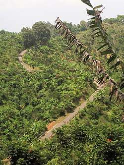 Cuesta de Magos, long, steep hill on PR-438 heading to Río Culebrinas, photographed with zoom lens from barrio Calabazas | |
 Magos | |
| Coordinates: 18°18′30″N 66°56′37″W[1] | |
| Commonwealth | |
| Municipality | |
| Area | |
| • Total | 1.42 sq mi (3.7 km2) |
| • Land | 1.42 sq mi (3.7 km2) |
| • Water | 0 sq mi (0 km2) |
| Elevation | 804 ft (245 m) |
| Population (2010) | |
| • Total | 232 |
| • Density | 163.4/sq mi (63.1/km2) |
| Source: 2010 Census | |
| Time zone | UTC−4 (AST) |
History
The United States took control of Puerto Rico from Spain in the aftermath of the Spanish-American War under the terms of the Treaty of Paris of 1898. In 1899, the United States conducted its first census of Puerto Rico finding that the combined population of Magos and Eneas barrios was 1,003.[6]
Sectors
Barrios (which are like minor civil divisions)[7] in turn are further subdivided into smaller local populated place areas/units called sectores (sectors in English). The types of sectores may vary, from normally sector to urbanización to reparto to barriada to residencial, among others.[8][9][10]
The following sectors are in Magos barrio:[11]
Carretera 438, Carretera 451, Carretera 470, Sector Ballester, Sector La Cuadra, Sector Melito Oliva, Sector Miguel A. Pérez, Sector Puente Lajas, Sector Pujols, Sector Sonoco, Sector Toño Jiménez, and Urbanización Santa Teresita.
Río Culebrinas
There is a bridge on PR-438 that goes over the Culebrinas River in barrio Magos and when the river floods the road is closed.[12][13]
Gallery
 At bottom of Cuesta de Magos near Río Culebrinas
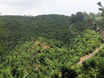 Cuesta de Magos as seen from barrio Calabazas, San Sebastián
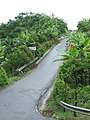
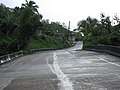 Slanted bridge at bottom of hill, on PR-438 over Río Culebrinas in barrio Magos
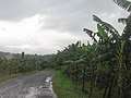 Cuesta de Magos in barrio Magos, PR-438
 Vegetation and fruit trees at bottom of "Magos Hill"
See also
References
- "US Gazetteer 2019". US Census. US Government.
- U.S. Geological Survey Geographic Names Information System: Magos barrio
- Picó, Rafael; Buitrago de Santiago, Zayda; Berrios, Hector H. Nueva geografía de Puerto Rico: física, económica, y social, por Rafael Picó. Con la colaboración de Zayda Buitrago de Santiago y Héctor H. Berrios. San Juan Editorial Universitaria, Universidad de Puerto Rico,1969.
- Gwillim Law (20 May 2015). Administrative Subdivisions of Countries: A Comprehensive World Reference, 1900 through 1998. McFarland. p. 300. ISBN 978-1-4766-0447-3. Retrieved 25 December 2018.
- Puerto Rico:2010:population and housing unit counts.pdf (PDF). U.S. Dept. of Commerce, Economics and Statistics Administration, U.S. Census Bureau. 2010.
- Joseph Prentiss Sanger; Henry Gannett; Walter Francis Willcox (1900). Informe sobre el censo de Puerto Rico, 1899, United States. War Dept. Porto Rico Census Office (in Spanish). Imprenta del gobierno. p. 160.
- "US Census Barrio-Pueblo definition". factfinder.com. US Census. Archived from the original on 13 May 2017. Retrieved 5 January 2019.
- "Agencia: Oficina del Coordinador General para el Financiamiento Socioeconómico y la Autogestión (Proposed 2016 Budget)". Puerto Rico Budgets (in Spanish). Retrieved 28 June 2019.
- Rivera Quintero, Marcia (2014), El vuelo de la esperanza: Proyecto de las Comunidades Especiales Puerto Rico, 1997-2004 (first ed.), San Juan, Puerto Rico Fundación Sila M. Calderón, ISBN 978-0-9820806-1-0
- "Leyes del 2001". Lex Juris Puerto Rico (in Spanish). Retrieved 24 June 2020.
- "PRECINTO ELECTORAL SAN SEBASTIÁN 033" (PDF). Comisión Estatal de Elecciones (in Spanish). PR Government. 19 October 2018. Retrieved 19 June 2019.
- "Río Culebrinas trae problemas al tránsito en el oeste". NOTICEL CyberNews (in Spanish). 30 May 2019.
- https://www.wipr.pr/extienden-aviso-de-inundaciones-por-rio-culebrinas/