Meteosat
The Meteosat series of satellites are geostationary meteorological satellites operated by EUMETSAT under the Meteosat Transition Programme (MTP) and the Meteosat Second Generation (MSG) program.

The MTP program was established to ensure the operational continuity between the end of the successful Meteosat Operational Programme in 1995 and Meteosat Second Generation (MSG), which came into operation at the start of 2004 using improved satellites. The MSG program will provide service until the MTG (Meteosat Third Generation) program takes over.
First generation
| Satellite | Launch date | Mission end |
|---|---|---|
| Meteosat-1 | 23 November 1977 | Imager failed in November 1979; data collection ended in 1984 |
| Meteosat-2 | 10 June 1981 | De-orbited in December 1991 |
| Meteosat-3 (Meteosat-P2) | 15 June 1988 | Retired in 1995 |
| Meteosat-4 (MOP-1) | 19 April 1989 | Deactivated in November 1996. |
| Meteosat-5 (MOP-2) | 02 March 1991 | Decommissioned and placed into graveyard orbit February 2007 |
| Meteosat-6 (MOP-3) | 20 November 1993 | Continued data transmission service until late 2010 or in early 2011 |
| Meteosat-7 (MOP-4) | 03 September 1997 | De-orbited April 2017[2] |
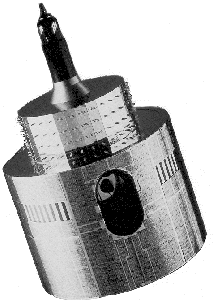
The first generation of Meteosat satellites, Meteosat-1 to Meteosat-7, provided continuous and reliable meteorological observations from space to a large user community. Meteosat-1 to 7 have all now retired. When operational the Meteosat First Generation provided images every half-hour in three spectral channels (Visible, Infrared) and Water Vapour, via the Meteosat Visible and Infrared Imager (MVIRI) instrument. Until 1-February 2017, Meteosat-7 provided the primary imagery coverage over the Indian Ocean and provided a service relaying data from Data Collection Platforms (DCP), such as buoys, in support of the Tsunami Warning System for the Indian Ocean. A range of processed meteorological products were also produced.[3] The last disseminated Meteosat-7 image was on 31-March-2017. Meteosat-7 de-orbiting commenced on 3-April-2017 and the spacecraft final command sent on 11-April 2017.
The satellites were manufactured by a consortium COSMOS, with Aérospatiale in its Cannes Mandelieu Space Centre, as Prime, and included Matra, MBB, Selenia Spazio, Marconi Company.
They are 2.1 metres in diameter and 3.195 metres long. Its initial mass in orbit is 282 kg, and in orbit, the satellite spins at 100 rpm around its main axis.[4]
Second Generation

| Satellite | Launch date | Mission end |
|---|---|---|
| Meteosat-8 | 28 August 2002 | Availability lifetime is until 2022 |
| Meteosat-9 | 22 December 2005 | Availability lifetime is until 2025 |
| Meteosat-10 | 05 July 2012 | Availability lifetime is until 2030 |
| Meteosat-11 | 15 July 2015 | Availability lifetime is until 2033 |
The contract for the second generation was awarded to Aérospatiale in its Cannes Mandelieu Space Centre (now Thales Alenia Space), with main subcontractors as Matra, Messerschmitt, Alenia.
Meteosat Second Generation was designed in response to user requirements to serve the needs of Nowcasting applications and numerical weather prediction. In addition, the GERB instrument provides important data for climate monitoring and research.
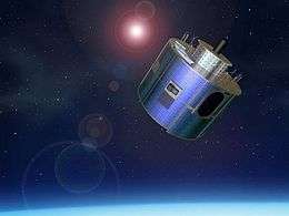
The satellites are spin-stabilised like the previous generation, but with many design improvements. The more frequent and comprehensive data collected by MSG also aids the weather forecaster in the swift recognition and prediction of dangerous weather phenomena such as thunderstorms, fog, and explosive development of small, but intense, depressions, which can lead to devastating wind storms.
The MSG satellites are 3.2 m in diameter and 2.4 m high and spin anti-clockwise at 100 RPM [6] at an altitude of 36,000 km.[7]
On 29 January 2004 the first Meteosat Second Generation satellite MSG-1, renamed to Meteosat-8 once operational, commenced routine operations. In addition to the main optical payload SEVIRI (Spinning Enhanced Visible and Infrared Imager), Meteosat-8 also carries the secondary payload GERB (Geostationary Earth Radiation Budget) instrument.
The launch of MSG-2 (renamed to Meteosat-9) took place on 21 December 2005. The launch of MSG-3 (renamed to Meteosat-10) took place on 5 July 2012.

Meteosat-8, -9 and 10 are all operational.
Meteosat-8 is stationed over the Indian Ocean, arriving at 41.5°E on 21 September 2016 and it took over as prime Indian Ocean Data Coverage (IODC) spacecraft on 1 February 2017 (replacing Meteosat-7). Meteosat-7 was moved to its graveyard orbit with the last command sent on 11-April 2017.
Meteosat-9 and -10 are all located over Africa with various differences in operational configuration. Meteosat-9 provides an operational European 'rapid scan' mode service (the MSG RSS service first commenced in May 2008), with images of Europe every 5 minutes. Meteosat-10 provides the main full Earth imagery service over Europe and Africa (with images every 15-minutes).
MSG-4 was successfully launched into space on 15 July 2015 at 18:42 local time on top an Ariane 5 Rocket from the Guiana Space Centre in Kourou, French Guiana. Like MSG-1, MSG-2 and MSG-3, MSG-4 was launched by Arianespace. The MSG-4 commissioning was successfully completed in December 2015 at which time the spacecraft was placed into in-orbit storage as planned, and renamed to Meteosat-11.
Between January and April 2018 several changes in the constellation of Meteosat satellites will be made. Meteosat-11 will be taken into operations, moved to 0-deg longitude and take over the main full Earth imagery service over Europe and Africa from Meteosat-10. Following this Meteosat-10 will be moved to 9.5-deg E longitude and take over the operational European 5-minute 'rapid scan' mode service from Meteosat-9. Finally Meteosat-9 will be moved to 3.5-deg E longitude and be available as a 'rapid scan' mode service backup to Meteosat-10.
Secondary Payloads
Meteosat-8,-9, 10, and -11 each carry a GERB Instrument, DCP capable service equipment and a Search and Rescue signal Processor (SARP) that is capable of detecting 406 MHz distress signals from Emergency position-indicating radiobeacon stations.[8] For SARP see more under Cospas-Sarsat.
Third Generation ("MTG")
Considering the long development cycle for a new observational space system, EUMETSAT has been working on the definition and the planning for a Meteosat Third Generation (MTG) system since the year 2000. MTG components providing continuity of MSG services need to be available before the end of the nominal lifetime of MSG. MTG preparatory activities started end of 2000 in cooperation with the European Space Agency (ESA), following the decision of the EUMETSAT Council to proceed with a Post-MSG User Consultation Process. The process is aimed at capturing the foreseeable needs of users of EUMETSAT's satellite data in the 2015-2025 timeframe.[9]
On 19 March 2010, ESA chose Thales Alenia Space for a final negotiation leading to a contract to be signed during June.[10]
On 22 June 2010, EUMETSAT confirmed the choice of Thales Alenia Space.[11]
On 24 February 2012, the development contract between ESA and Thales Alenia Space was signed by Mr. Liebig and Mr. Seznec. Thales Alenia Space leads the industrial consortium that is now building the MTG family. Along with being the prime contractor, Thales Alenia Space is responsible for the MTG-I imaging satellite, including the primary payload, the Flexible Combined Imager.
Bremen-based OHB is responsible for the MTG-S satellites and provision of the common satellite platforms, supported by Astrium GmbH as the System Architect.
References
- EUMETSAT
- "Perfect day for weather satellite". BBC News. December 21, 2005. Retrieved February 6, 2006.
- Krige, John. "Crossing the Interface from R&D to Operational Use: The Case of the European Meteorological Satellite," Technology and Culture, Volume 41, Number 1, January 2000, pp. 27–50.
- https://directory.eoportal.org/web/eoportal/satellite-missions/m/meteosat-first-generation
- "Archived copy". Archived from the original on 2017-06-13. Retrieved 2019-04-02.CS1 maint: archived copy as title (link)
- "Indian Ocean Data Coverage service". Archived from the original on 2017-12-01. Retrieved 2018-11-29.
- Meteosat First Generation Design
- https://www.eumetsat.int/website/home/Satellites/CurrentSatellites/Meteosat/index.html
- Meteosat Second Generation Design
- EUMETSAT Satellite Orbits
- "Current Space Segment Status and SAR Payloads". Archived from the original on 2012-11-30. Retrieved 2012-12-03.
- Meteosat Third Generation
- ESA and Thales Alenia Space enter negotiations for MTG, ESA Press release, March 19, 2010, online www.esa.int
- EUMETSAT 70th council puts MTG on tracks
External links
| Wikimedia Commons has media related to EUMETSAT. |