Lydia, South Carolina
Lydia (formerly Mount Elon) is an unincorporated community and census-designated place (CDP) in Darlington County, South Carolina, United States. As of the 2010 census, the population of the CDP was 642.[1] It is the location of Lydia Plantation, which is listed on the U.S. National Register of Historic Places.
Lydia, South Carolina | |
|---|---|
 Lydia Location of Lydia, South Carolina | |
| Coordinates: 34°17′16″N 80°7′13″W | |
| Country | United States |
| State | South Carolina |
| County | Darlington |
| Area | |
| • Total | 2.64 sq mi (6.8 km2) |
| • Land | 2.64 sq mi (6.8 km2) |
| • Water | 0.00 sq mi (0.0 km2) |
| Elevation | 213 ft (65 m) |
| Population (2010) | |
| • Total | 642 |
| • Density | 243/sq mi (94/km2) |
| Time zone | UTC-5 (Eastern (EST)) |
| • Summer (DST) | UTC-4 (EDT) |
| ZIP code | 29079 |
| FIPS code | 45-43135[1] |
| GNIS feature ID | 2629835[2] |
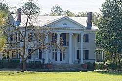
Lydia Plantation house
Lydia is in western Darlington County, just east of the Lee County line. U.S. Route 15 passes through the community, leading northeast 7 miles (11 km) to Hartsville and southwest 10 miles (16 km) to Bishopville. South Carolina Highway 34 leads east 14 miles (23 km) to Darlington, the county seat.
Geography
According to the U.S. Census Bureau, the Lydia CDP has an area of 2.6 square miles (6.8 km2), all land.[1]
gollark: It may be a super glorified Markov chain, except not really I don't think the architecture is very similar, but it's a very good one.
gollark: GPT-2 and -3 are actually really impressive and there's good image object detection and stuff now.
gollark: The registry is somehow worse than random config files, and you're limited by what options Microsoft deigned to put in.
gollark: hahahahahahahaaahahahahahahahhahahaahahhahahhhahahahahahahhhahhhhhhhhhhhahahha again.
gollark: I mean, if you don't care about customizability or tracking or not randomly breaking, *maybe*?
References
- "Geographic Identifiers: 2010 Demographic Profile Data (G001): Lydia CDP, South Carolina". U.S. Census Bureau, American Factfinder. Archived from the original on February 13, 2020. Retrieved January 5, 2016.
- "US Board on Geographic Names". United States Geological Survey. 2007-10-25. Retrieved 2008-01-31.
Municipalities and communities of Darlington County, South Carolina, United States | ||
|---|---|---|
| Cities | 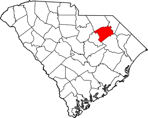 Map of South Carolina highlighting Darlington County | |
| Towns | ||
| CDP | ||
| Other unincorporated communities | ||
| Ghost towns | ||
| Footnotes | ‡This populated place also has portions in an adjacent county or counties | |
This article is issued from Wikipedia. The text is licensed under Creative Commons - Attribution - Sharealike. Additional terms may apply for the media files.