Ludlow Parish, New Brunswick
Ludlow is a civil parish[lower-alpha 1] in Northumberland County, New Brunswick, Canada.[2]
Ludlow | |
|---|---|
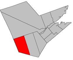 Location within Northumberland County, New Brunswick | |
| Coordinates: 46.49°N 66.35°W | |
| Country | |
| Province | |
| County | Northumberland |
| Established | 1814 |
| Area | |
| • Land | 1,016.66 km2 (392.53 sq mi) |
| Population (2011)[1] | |
| • Total | 1,543 |
| • Density | 1.5/km2 (4/sq mi) |
| • Pop 2006-2011 | |
| • Dwellings | 772 |
| Time zone | UTC-4 (AST) |
| • Summer (DST) | UTC-3 (ADT) |
For governance purposes it is part of the incorporated rural community of Upper Miramichi.[3]
Delineation
Ludlow Parish is defined in the Territorial Division Act[2] as being bounded:
- West and south by the County lines; north by Southesk Parish; and east by a line running north and south from the mouth of Big Hole Brook.
Communities
- Carrolls Crossing
- Ludlow
- McNamee
- Porter Cove
- Priceville
Demographics
PopulationPopulation trend[4]
|
LanguageMother tongue language (2006)[5]
|
gollark: TLC is three...
gollark: MLC is two bits a cell...
gollark: NAND flash had turned out to be waaay more reliable than people thought, I suspect.
gollark: My TLC one is still fine after about four years.
gollark: Ooh, cool.
See also
Notes
- Civil parishes served a variety of government functions until 1966, when the new Municipalities Act stripped them of their responsibilities; they continue to provide convenient boundaries for government uses, especially electoral districts and local service districts. Statistics Canada uses civil parishes as census subdivisions for all parts of the province that are not within municipalities and similar entities.
References
- 2011 Statistics Canada Census Profile: Ludlow Parish, New Brunswick
- "Chapter T-3 Territorial Division Act". Government of New Brunswick. Retrieved 22 July 2020.
- "New Brunswick Regulation 2008-37 under the Municipalities Act (O.C. 2008-110)". Government of New Brunswick. Retrieved 22 July 2020.
- Statistics Canada: 1996, 2001, 2006 census
- 2006 Statistics Canada Community Profile: Ludlow Parish, New Brunswick
External links
Places adjacent to Ludlow Parish, New Brunswick | ||||||||||
|---|---|---|---|---|---|---|---|---|---|---|
| ||||||||||
| Subdivisions |
|
|---|---|
| Cities | |
| Counties | |
| |
This article is issued from Wikipedia. The text is licensed under Creative Commons - Attribution - Sharealike. Additional terms may apply for the media files.