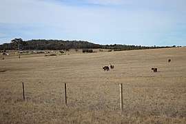
Lower Boro
Lower Boro is a locality in the Goulburn Mulwaree Council area, New South Wales, Australia.[2] It is located about 16 km southeast of Tarago. The link from Tarago to Windellama, which is part of a link from Canberra to Nerriga and Nowra, passes through the northern part of the locality. At the 2016 census, Lower Boro had a population of 176.[1]
| Lower Boro New South Wales | |||||||||||||||
|---|---|---|---|---|---|---|---|---|---|---|---|---|---|---|---|
 Lower Boro | |||||||||||||||
 Lower Boro Location in New South Wales | |||||||||||||||
| Coordinates | 35°11′28″S 149°47′17″E | ||||||||||||||
| Population | 176 (2016 census)[1] | ||||||||||||||
| Postcode(s) | 2580 | ||||||||||||||
| Location | |||||||||||||||
| LGA(s) | Goulburn Mulwaree Council | ||||||||||||||
| Region | Southern Tablelands | ||||||||||||||
| County | Argyle | ||||||||||||||
| Parish | Boro | ||||||||||||||
| State electorate(s) | Goulburn | ||||||||||||||
| Federal Division(s) | Hume | ||||||||||||||
| |||||||||||||||
Heritage listings
Lower Boro has a number of heritage-listed sites, including:
gollark: What do they do? How do you define a new function?
gollark: What are they?
gollark: Okay, what should the builtins and stuff be?
gollark: Ugh, I am going to need to totally rewrite the actual Soviet Forth language at this rate.
gollark: ++smite edgy
References
| Wikimedia Commons has media related to Lower Boro. |
- Australian Bureau of Statistics (27 June 2017). "Lower Boro". 2016 Census QuickStats. Retrieved 5 August 2017.

- "Lower Boro". Geographical Names Register (GNR) of NSW. Geographical Names Board of New South Wales. Retrieved 5 August 2017.

- "Mayfield". New South Wales State Heritage Register. Office of Environment and Heritage. H01365. Retrieved 18 May 2018.
This article is issued from Wikipedia. The text is licensed under Creative Commons - Attribution - Sharealike. Additional terms may apply for the media files.