Louisiana Highway 308
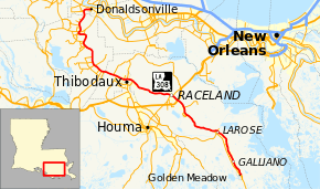
Louisiana Highway 308 (LA 308) is a state highway in Louisiana that serves Ascension, Assumption, and Lafourche Parishes. It spans 82.5 miles (132.8 km), following the east bank of Bayou Lafourche from Donaldsonville to Golden Meadow.[1] It parallels LA 1 during its entire route, as LA 1 follows the west bank of the bayou.
| ||||
|---|---|---|---|---|
 | ||||
| Route information | ||||
| Maintained by Louisiana DOTD | ||||
| Length | 82.5 mi[1] (132.8 km) | |||
| Existed | 1955 renumbering–present | |||
| Major junctions | ||||
| Southeast end | ||||
| ||||
| Northwest end | ||||
| Location | ||||
| Parishes | Lafourche, Assumption, Ascension | |||
| Highway system | ||||
| ||||
Route description
LA 308 is the eastbank counterpart to LA 1, as it follows the east side of Bayou Lafourche. As the eastbank of Bayou Lafourche is generally less populated than the westbank, LA 308 serves as a slightly quicker route towards south central Louisiana and lower Bayou Lafourche than LA 1. Throughout its route, there are bridges that cross Bayou Lafourche to connect LA 308 to LA 1 and local communities. LA 308 is known as Bayou Road in Thibodaux and East Main Street south of Larose.
The route begins in Donaldsonville at LA 3089 and is known as East Bayou Road in that community. It passes through the following communities: Belle Rose, Plattenville, Thibodaux, Raceland, Mathews, Lockport, Larose, Cut Off, and Galliano. Just north of Golden Meadow, LA 308 crosses Bayou Lafourche over a steel movable lift bridge built in 1970 and intersects at LA 1, the southern terminus. LA 1 continues towards Leeville and Grand Isle.
Major intersections
| Parish | Location | mi[1] | km | Destinations | Notes |
|---|---|---|---|---|---|
| Lafourche | Golden Meadow | 0.0 | 0.0 | Southern terminus | |
| 0.0 | 0.0 | Bridge over Bayou Lafourche | |||
| Galliano | 6.7 | 10.8 | Eastern terminus of LA 3162 | ||
| Larose | 14.8 | 23.8 | |||
| 15.2 | 24.5 | Bridge over Gulf Intracoastal Waterway | |||
| | 25.6 | 41.2 | Eastern terminus of LA 3220 | ||
| Rita | 26.7 | 43.0 | Eastern terminus of LA 655 | ||
| 27.2 | 43.8 | Bridge over Company Canal | |||
| Mathews | 29.2 | 47.0 | |||
| Raceland | 32.0 | 51.5 | Exit 215B (U.S. 90); Eastbound entrance and westbound exit | ||
| 34.2 | 55.0 | ||||
| St. Charles | 42.6 | 68.6 | Northern terminus of LA 649 | ||
| | 47.2 | 76.0 | Northeastern terminus of LA 648 | ||
| Thibodaux | 49.1 | 79.0 | South end of LA 20 concurrency | ||
| 49.4 | 79.5 | North end of LA 20 concurrency | |||
| | 50.2 | 80.8 | Southern terminus of LA 3266 | ||
| | 51.1 | 82.2 | Northwestern terminus of LA 3185 | ||
| Laurel Grove | 53.5 | 86.1 | Southern terminus of LA 304 | ||
| Assumption | | 58.0 | 93.3 | Northern terminus of LA 1247 | |
| Leche | 59.7 | 96.1 | Southwestern terminus of LA 1014 | ||
| | 60.2 | 96.9 | Eastern terminus of LA 1011 | ||
| | 62.8 | 101.1 | Northern terminus of LA 1010 | ||
| | 66.9 | 107.7 | Northeastern terminus of LA 1008 | ||
| | 68.0 | 109.4 | Eastern terminus of LA 402 | ||
| Plattenville | 71.0 | 114.3 | |||
| | 72.6 | 116.8 | Northern terminus of LA 403 | ||
| | 73.1 | 117.6 | |||
| | 76.9 | 123.8 | Southeastern terminus of LA 998 | ||
| Ascension | | 79.8 | 128.4 | Southeastern terminus of LA 943 | |
| Donaldsonville | 81.9 | 131.8 | Western terminus of LA 945 | ||
| 82.5 | 132.8 | Northern terminus | |||
1.000 mi = 1.609 km; 1.000 km = 0.621 mi
| |||||
Louisiana Highway 308 Spur
| |
|---|---|
| Location | Galliano |
| Length | 0.69 mi (1.11 km) |
| Existed | 1970–1994 |
LA 308 Spur provided a connection between LA 3235 and LA 1 on the west bank of Bayou Lafourche with LA 308 on the east bank in Galliano. The route is now LA 3162.
The entire highway was in Galliano, Lafourche Parish.
| mi | km | Destinations | Notes | ||
|---|---|---|---|---|---|
| 0.00 | 0.00 | Western terminus | |||
| 0.63 | 1.01 | ||||
| 0.66 | 1.06 | Bridge over Bayou Lafourche | |||
| 0.69 | 1.11 | Eastern terminus | |||
| 1.000 mi = 1.609 km; 1.000 km = 0.621 mi | |||||
References
- Microsoft; Nokia (November 9, 2012). "Map of LA 308" (Map). Bing Maps. Microsoft. Retrieved November 9, 2012.
.svg.png)