Los Nopalitos, Texas
Los Nopalitos is a census-designated place (CDP) in Webb County, Texas, United States. This was a new CDP for the 2010 census with a population of 62.[1]
Los Nopalitos, Texas | |
|---|---|
| Coordinates: 27°37′10″N 99°12′20″W | |
| Country | United States |
| State | Texas |
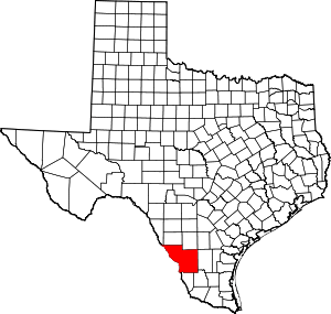
| County | Webb |
| Area | |
| • Total | 0.1 sq mi (0.3 km2) |
| • Land | 0.1 sq mi (0.3 km2) |
| • Water | 0.0 sq mi (0 km2) |
| Population (2010) | |
| • Total | 62 |
| • Density | 620/sq mi (240/km2) |
| Time zone | UTC-6 (Central (CST)) |
| • Summer (DST) | UTC-5 (CDT) |
| Zip Code | 78043 |
Geography
Los Nopalitos is located at 27°37′10″N 99°12′20″W (27.619521, -99.205609). The CDP has a total area of 0.1 square miles (0.26 km2), all land.[2]
gollark: Please stop spamming that video.
gollark: It certainly seems kind of bad right now.
gollark: Because there are no *people* in countries you dislike, of course.
gollark: Did you know? Economic collapses are generally bad for people.
gollark: I feel like in some places coronavirus mitigation has gone up to excessive and possibly not all that helpful levels.
References
- "Population and Housing Unit Counts, 2010 Census of Population and Housing" (PDF). Texas: 2010. Retrieved 2017-01-03.
- "Boundary Map of Los Nopalitos, Texas". MapTechnica. Retrieved 2017-01-03.
This article is issued from Wikipedia. The text is licensed under Creative Commons - Attribution - Sharealike. Additional terms may apply for the media files.