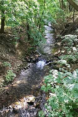
Lopatcong Creek
Lopatcong Creek is a 12.0-mile-long (19.3 km)[1] tributary of the Delaware River in Warren County, New Jersey in the United States.[2]
| Lopatcong Creek | |
|---|---|
 Lopatcong Creek in Phillipsburg, New Jersey near the former Morris Canal | |
| Location | |
| Country | United States |
| State | New Jersey |
| Region | Warren County |
| Physical characteristics | |
| Source | Scotts Mountain |
| Mouth | Delaware River |
• location | Phillipsburg |
• coordinates | 40°40′45″N 75°10′42″W |
| Basin features | |
| River system | Delaware River |
The source of the stream is Scotts Mountain in Harmony Township.[3] It was one of the chief water sources for the Morris Canal, in particular from Inclined Plane 9 West in Port Warren to Lock 10 West in the Green's Bridge section of Phillipsburg.[4][5]
The Lopatcong joins the Delaware in Phillipsburg.
See also
References
- U.S. Geological Survey. National Hydrography Dataset high-resolution flowline data. The National Map, accessed December 21st, 2019
- "Lopatcong Creek". Geographic Names Information System. United States Geological Survey.
- Snell, James P.; Clayton, W.W. (1881). "Harmony". History of Sussex and Warren Counties, New Jersey, with Illustrations and Biographical Sketches of its Prominent Men and Pioneers. Philadelphia: Everts & Peck. pp. 671. OCLC 14075041.
- Kalata, Barbara (October 10, 1973). "National Register of Historic Places Inventory/Nomination: Morris Canal". National Park Service. With 25 accompanying photos
- "Water and the Canal" (PDF). Warren County Morris Canal Greenway.
External links

- Official website

- "Lock Street: Plane 10 West to Lock 8 West" (PDF). Warren County Morris Canal Greenway.
This article is issued from Wikipedia. The text is licensed under Creative Commons - Attribution - Sharealike. Additional terms may apply for the media files.