Listed buildings in Kronoberg County
Alvesta Municipality
| Image | Name | Premises | Number of buildings |
Year built | Architect | Coordinates | ID |
|---|---|---|---|---|---|---|---|
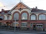 |
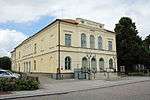
Alvesta stationshus | Alvesta 11:1 | 1 | 56.89904°N 14.55685°E | 21300000013690 | ||
| Alvesta tingshus | Gästgivaren 2 | 2 | 56.89846°N 14.55139°E | 21300000025711 | |||
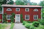
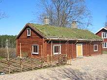
| Gåvetorps herrgård | Gåvetorp 6:1, 7:10 | 16 | 56.95051°N 14.58205°E | 21300000013697 | |||
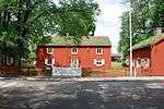
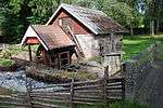
| Halmhyddorna på Kronobergshed | Dansjö 2:41 | 2 | 56.97150°N 14.56500°E | 21300000013717 | |||
.jpg) |
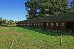
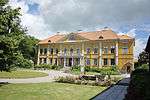
Huseby bruk | Huseby 1:1 m fl | 27 | 56.77858°N 14.59004°E | 21300000013721 | ||
 |
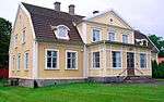
Riksdagsmannagården | Krigaren 1 | 5 | 56.89831°N 14.55270°E | 21300000013691 |
Lessebo Municipality
| Image | Name | Premises | Number of buildings |
Year built | Architect | Coordinates | ID |
|---|---|---|---|---|---|---|---|
| Glashusen i Kosta | Kosta 3:30 m fl | 5 | 56.85064°N 15.39829°E | 21300000026402 | |||
 |
Södra kyrkstallarna i Ljuder | Ljuders prästgård 1:13 (fd1:1 | 1 | 56.68042°N 15.31615°E | 21300000013734 | ||
| Transjö Folkets hus | Transjö 1:53 (fd1:5 | 2 | 56.78827°N 15.41636°E | 21300000013732 |
Ljungby Municipality
| Image | Name | Premises | Number of buildings |
Year built | Architect | Coordinates | ID |
|---|---|---|---|---|---|---|---|
| Kvarteret Gertrud 25 | Gertrud 25 | 2 | 56.82996°N 13.93950°E | 21300000018415 | |||
| Hamneda gamla gästgivaregård | Hamneda 1:7 | 2 | 56.69256°N 13.84240°E | 21300000013736 | |||
| Sällebergs herrgård | Sälleberg 1:11 | 2 | 56.85725°N 14.23291°E | 21300000013741 |
Markaryd Municipality
There are no listed buildings in Markaryd Municipality.
Tingsryd Municipality
| Image | Name | Premises | Number of buildings |
Year built | Architect | Coordinates | ID |
|---|---|---|---|---|---|---|---|
| Linneryds kyrkstallar, sockenstuga | Linneryd 3:5 | 5 | 56.65667°N 15.13033°E | 21000001216420 | |||
| Linneryds sockenmagasin | Linneryd 5:89 | 1 | 56.65785°N 15.13158°E | 21000001468682 | |||
| Lidhems säteri | Line 7:1 | 14 | 56.66209°N 14.88210°E | 21300000013745 |
Uppvidinge Municipality
| Image | Name | Premises | Number of buildings |
Year built | Architect | Coordinates | ID |
|---|---|---|---|---|---|---|---|
 |
Lenhovda gamla tingshus | Lenhovda 3:15 | 2 | 56.99715°N 15.28520°E | 21300000013750 | ||
| Norrhults Folkets hus | Norrhult 3:579 | 3 | 57.12103°N 15.16593°E | 21300000013752 | |||
| Rosdala glasbruk | Norrhult 60:1, 60:3 | 23 | 57.12204°N 15.17359°E | 21300000013756 |
Växjö Municipality
| Image | Name | Premises | Number of buildings |
Year built | Architect | Coordinates | ID |
|---|---|---|---|---|---|---|---|
| Växjö gamla gymnasium/Karoliner huset | Domkyrkan 1 previously Gymnasiet 1 |
1 | 56.87781°N 14.81229°E | 21300000013788 | |||
 |
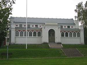
Växjö teater | Tullen 17 previously Teatern 6 |
1 | 1849 | Theodor Anckarsvärd | 56.87984°N 14.80341°E | 21300000013789 |
 |
Smålands museum, Växjö | Museet 3 | 2 | 56.87593°N 14.80795°E | 21300000013786 | ||
| Dädesjö gamla prästgård | Dädesjö 1:9; f.d 1:1 | 8 | 57.01231°N 15.10753°E | 21300000013780 | |||
 |
Lilla Björka | Berg 16:1, 17:1 | 3 | 57.08057°N 14.71148°E | 21300000013763 | ||
 |
Sankt Sigfrids sjukhus | Växjö 11:40 previously Stg 2097 |
2 | 56.86690°N 14.82719°E | 21300000013790 | ||
| Gårdsby säteri | Gårdsby 6:13 | 20 | 56.96000°N 14.89335°E | 21300000016697 | |||
| Jätsbergs herrgård | Jätsberg 1:18 | 11 | 56.68016°N 14.81202°E | 21300000013783 | |||
| Lilla Gunnarbo | Hov ödegård 10 | 2 | 56.88837°N 14.80686°E | 21300000013791 | |||
| Logehuset i Drev | Drev 8:4 | 1 | 57.06895°N 14.99997°E | 21300000013764 | |||
| Ordenshuset Asa-Thor | Asa-Kråketorp S:1 | 1 | 57.18445°N 14.77384°E | 21300000013762 | |||
| Skälsnäs ryttmästarboställe | Skälsnäs 1:1 | 7 | 56.98094°N 14.74232°E | 21300000013784 | |||
| Gamla Riksbanken, Växjö | Lyktan 4 | 1 | 56.87880°N 14.81074°E | 21300000013794 | |||
| Residenset, Växjö | Residenset 1 | 1 | 56.87895°N 14.80946°E | 21300000013792 | |||
 |
Åryds bruk | Åryd 1:31 | 1 | 56.82459°N 14.98792°E | 21300000013782 | ||
 |
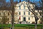
Östrabo biskopsgård | Östrabo 1 previously 1:1 |
7 | 1792–1796 | Olof Tempelman | 56.87955°N 14.81888°E | 21300000013795 |
Älmhult Municipality
| Image | Name | Premises | Number of buildings |
Year built | Architect | Coordinates | ID |
|---|---|---|---|---|---|---|---|
| Emanuelskapellet | Sköldsbygd 1:11 (tidigare Sköldsbygd Östergård 1:11 | 1 | 56.53951°N 13.95486°E | 21300000013823 | |||
 |
Råshult | Råshult 2:1 | 3 | 56.61824°N 14.19947°E | 21300000013827 | ||
| Stora Kölaboda | Kölaboda 3:23 (f.d 3:2 | 3 | 56.54986°N 13.97590°E | 21300000013825 |
gollark: There are some reasonable arguments regarding animal welfare. While IIRC the insect meat is more energy-dense, insects are small so you need lots more insects to get some amount of energy than you would for, say, sheep. Most people would rank each insect as less important/worthy-of-moral-consideration than the sheep, but potentially not *enough* lower that it's equal/better given the large number.
gollark: It's not like they have spikes/thorns and poisons just for decoration.
gollark: I suppose there are a lot of policies which could be cool™ with good governance but are bad in any practical setting.
gollark: A while ago. I think this would be an example of "government bad".
gollark: And the variability in parenting unfairly affects children's life outcomes.
External links
| Wikimedia Commons has media related to Protected buildings in Kronoberg County. |
- (in Swedish) Bebyggelseregistret
This article is issued from Wikipedia. The text is licensed under Creative Commons - Attribution - Sharealike. Additional terms may apply for the media files.