List of tunnels of the Faroe Islands
Tunnels and bridges are an important part of the Faroese transportation network.[1]
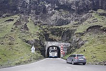
Árnafjarðartunnilin's entrance in Árnafjørður.
Tunnels
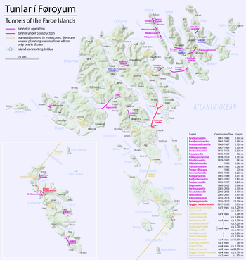
Locations of the tunnels
This list shows the Faroese tunnels, listed by age:[1][2]
| Tunnel | Year | Length m | ft | Connects | Island | Comments | |
|---|---|---|---|---|---|---|
| Old Hvalbiartunnilin | 1963 | 1,450 | 4,760 | Hvalba and Trongisvágur | Suðuroy | Single line with passing places, unlit. Replaced footpaths and post boat services. To be replaced by a modern tunnel in 2021. |
| Árnafjarðartunnilin | 1965 | 1,680 | 5,510 | Ánir, Klaksvík and Árnafjørður | Borðoy | One of the pair of Tunlarnir norður um Fjall (or alternatively known as Borðoyartunlarnir). Single line with passing places, unlit. Replaced footpaths and post boat services. To be replaced by a modern tunnel in 2024. |
| Hvannasundstunnilin | 1967 | 2,120 | 6,960 | Árnafjørður and Hvannasund/Norðdepil | Borðoy | One of the pair of Tunlarnir norður um Fjall (or alternatively known as Borðoyartunlarnir). Single line with passing places, unlit. Replaced footpaths and post boat services. To be replaced by a modern tunnel in 2025. |
| Sandvíkartunnilin | 1969 | 1,500 | 4,900 | Sandvík and Hvalba | Suðuroy | Single line with passing places, unlit. Replaced footpaths and post boat services. |
| Norðskálatunnilin | 1976 | 2,520 | 8,270 | Norðskáli and the valley Millum Fjarða | Eysturoy | First two-lane tunnel. First road connection between Southern Eysturoy and Northern Eysturoy. Replaced the Hósvík-Selatrað ferry crossing. |
| Leynartunnilin | 1977 | 760 | 2,490 | Leynar and the valley Kollafjarðardalur | Streymoy | Replaced an avalanche prone road. |
| Villingardalstunnilin | 1979 | 1,193 | 3,914 | The villages Mikladalur and Húsar | Kalsoy | Southernmost of the five Kalsoy tunnels. |
| Ritudalstunnilin | 1980 | 683 | 2,241 | The villages Mikladalur and Húsar | Kalsoy | One of the five Kalsoy tunnels. Single line with passing places, unlit. |
| Mikladalstunnilin | 1980 | 1,082 | 3,550 | The villages Mikladalur and Húsar | Kalsoy | One of the five Kalsoy tunnels. Single line with passing places, unlit. |
| Trøllanestunnilin | 1985 | 2,248 | 7,375 | The villages Trøllanes and Mikladalur | Kalsoy | Northernmost of the five Kalsoy tunnels. Single line with passing places, unlit. Replaced a footpath, post boat service and helicopter service (1983-1985). |
| Teymur í Djúpadal | 1979–85 | 220 | 720 | The Trøllanestunnilin and the uninhabited valley Djúpidalur | Kalsoy | One of the five Kalsoy tunnels. Effectively a branch of the Trøllanestunnilin to enable road access to pastures. Single line, unlit. |
| Leirvíkartunnilin | 1985 | 2,238 | 7,343 | Leirvík and Gøta | Eysturoy | Replaced a cliffside road that now is a touristic route. |
| Kunoyartunnilin | 1988 | 3,031 | 9,944 | Kunoy and Haraldssund | Kunoy | Single line with passing places, unlit. Replaced a ferry crossing. |
| Kollafjarðartunnilin | 1992 | 2,816 | 9,239 | Kollafjørður and Kaldbaksbotnur | Streymoy | Offers an alternative to the Oyrarvegurin mountain road, which is prone to icing and wind gusts in winter. |
| Sumbiartunnilin | 1997 | 3,240 | 10,630 | Sumba and Lopra | Suðuroy | Replaces a mountain pass that now is a touristic route. |
| Vágatunnilin | 2002 | 4,940 | 16,210 | Leynar and Fútaklett | Streymoy and Vágar | The first sub-sea tunnel. Replaced the Vestmanna-Vágar ferry. |
| Gásadalstunnilin | 2006 | 1,445 | 4,741 | Gásadalur and Bøur | Vágar | Single line with passing places. Replaced the footpath and helicopter service. |
| Norðoyatunnilin | 2006 | 6,186 | 20,295 | Klaksvík and Leirvík | Eysturoy and Borðoy | Replaced the Leirvík-Klaksvík and Leirvík-Kalsoy-Klaksvík ferry. |
| Hovstunnilin | 2007 | 2,435 | 7,989 | Øravík and Hov | Suðuroy | Replaced the cliffside road that now is a touristic route. |
| Viðareiðistunnilin | 2016 | 1,939 | 6,362 | Viðareiði with Hvannasund | Viðoy | Replaced the coastal road, which is prone to landslides and avalanches, but remains open as a touristic route. |
Bridges and causeways
This list shows the Faroese inter-insular bridges and causeways, also listed by age:
| Bridge | Year | Length m | ft | Connects | Island | Comments | |
|---|---|---|---|---|---|---|
| Brúgvin um Streymin | 1973 | 220 | 720 | Oyrarbakki/Norðskáli and Nesvík | Streymoy and Eysturoy | Concrete bridge. Replaced the ferry crossing from Nesvík to Oyrarbakki. |
| Byrging um Hvannasund | 1975 | 220 | 720 | Hvannasund and Norðdepil | Borðoy and Viðoy | Causeway. Replaced post and milk boat services. |
| Byrging um Haraldssund | 1986 | 350 | 1,150 | Haraldssund and Strond | Borðoy and Kunoy | Causeway. Replaced post and milk boat services.
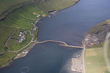 Causeway between Kunoy (left) and Borðoy (right). |
| Brúgvin um Sandá | 2016 | 140 | 460 | Argir and Tórshavn | Streymoy | The second longest bridge in the country.[3] |
Tunnels under construction
| Tunnel | Year | Approx. length m | ft | Connects | Island | Comments | |
|---|---|---|---|---|---|---|
| New Hvalbiartunnilin | Started in 2019, planned to open in 2021 | 2,500 | 8,200 | Hvalba and Trongisvágur | Suðuroy | Dual lane, lit. To replace the old Hvalbiartunnilin from 1963. |
| Eysturoyartunnilin | Started in 2016, planned to open in 2021 | 11,200 | 36,700 | Runavík and Strendur with Tórshavn | Streymoy and Eysturoy | Under Sundini and Skálafjørður. The tunnel will shorten the travel distance from Tórshavn to Runavík/Strendur from 55 kilometres to 17 kilometres. The 64 minute drive will be shortened to 17 minutes. The tunnel has a roundabout under the seabed at mid-bay.[4] |
| Sandoyartunnilin | Started in 2019, planned to open in 2023;[5] | 10,800 | 35,400 | Traðardalur and Gamlarætt | Streymoy and Sandoy | The tunnel starts just above the port of Gamlarætt and ends Traðardalur between Skopun and Sandur. |
| Dalstunnilin | Started in 2020, planned to open in 2023-2024 | 2,200 | 7,200 | Dalur with Húsavík | Sandoy | To replace the narrow cliffside road. The groundbreaking ceremony was in May 2019, drilling commences in autumn 2020 and will last 3–4 years.[6][7] |
Proposed tunnels
| Tunnel | Year | Approx. length m | ft | Connects | Island | Comments | |
|---|---|---|---|---|---|---|
| Suðuroyartunnilin | Expected to open in 2030. | 25,000 | 82,000 | Sandvík, Skúvoy and Sandur | Sandoy, Skúvoy and Suðuroy | The tunnel consists of two new tunnels and the Sandvíkartunnilin, which needs to be widened or replaced to allow interregional traffic.[8][9] |
| Nýggjur Árfjarðartunnilin | 2024 | 1,961 | 6,434 | Klaksvík, Ánir and Árnafjørður | Borðoy | One of the two Nýggir (new) Tunlarnir norður um Fjall (or alternatively Nýggir) Borðoyartunlarnir). Construction will commence in the end of 2020.[10] What will happen with the old tunnels remains unknown. |
| Nýggjur Hvannasundstunnilin | 2025 | 2,265 | 7,431 | Árnafjørður and Norðdepil | Borðoy | One of the two Nýggir (new) Tunlarnir norður um Fjall (or alternatively Nýggir) Borðoyartunlarnir). Construction will commence in the end of 2020.[10] What will happen with the old tunnels remains unknown. |
| Fámjinstunnilin | unknown | 0 | 0 | Øravík with Fámjin | Suðuroy | This road is among the windiest spots in the Faroe Islands and prone to icing in winter. The tender for construction opens in July 2020.[11] |
| Gjáartunnilin | unknown | 0 | 0 | Gjógv with Funningur | Eysturoy | To replace the narrow mountain pass, prone to icing in winter.[12] |
| Tjørnuvíkstunnilin | unknown | 0 | 0 | Tjørnuvík with Haldórsvík | Streymoy | To replace the narrow cliffside road. |
| Gøtudalstunnilin | unknown | 0 | 0 | Skálafjørður and Norðragøta | Eysturoy | To offer an alternative to the Gøtueiði mountain pass near Søldarfjørður, which is prone to icing and windgusts.[13] |
| Vestmannatunnilin | unknown | 0 | 0 | Kvívík and Vestmanna | Streymoy | to replace the cliffside road, prone to icing and windgusts. |
| Tunnel in the Innkomuvegurin | unknown | 700 | 2,300 | Hoyvík with Tórshavn | Streymoy | A short tunnel may be necessary in the Innkomuvegurin belt road, under Villingardalsvegurin and Oyrarvegurin [14] |
Operator
Public works authority Landsverk operates the national road network including all land-based tunnels. The four sub-sea tunnels have each their own state-owned company brought together under the daily management of Tunnil.fo, which administers the tolls. These are paid by drivers at select petrol stations, via number plate recognition. Reduced fares are available for vehicles with a subscription (in Faroese: hald). Tórshavn Municipality owns the Sandá Bridge.[15]
gollark: I do not think printing money on generic printers is actually a significant threat.
gollark: It is*, yes.
gollark: https://en.wikipedia.org/wiki/Machine_Identification_Code
gollark: Printers embed their serial number and such secretly into output documents.
gollark: (that + the steganography one)
See also
References
- "Tunlar" (in Faroese). Tórshavn: Landsverk. Archived from the original on 2 October 2015. Retrieved 1 October 2015.
- "Søgulig gongd" (in Faroese). Tórshavn: Landsverk. Archived from the original on 29 December 2008. Retrieved 22 April 2011.
- https://jkp.fo/brugvin-vid-sanda/
- "The Eysturoy tunnel". estunlar.fo. Retrieved 19 November 2016.
- "Framgongd við boring". tunnil.fo. 8 July 2020. Retrieved 8 July 2020.
- https://www.landsverk.fo/fo-fo/sjoetul-endiliga-settur-a-dalstunnilin
- https://dagur.fo/byrja-at-bora-dalstunnilin-i-heyst
- "Suðuroy subsea tunnel research shows early promise". Kringvarp Føroya (in Faroese). 26 November 2018.
- "Minister: Suðuroy tunnel ready in 2030". Kringvarp Føroya (in Faroese). 5 February 2020.
- https://www.landsverk.fo/fo-fo/tunlarnir-nor%C3%B0ur-um-fjall-4
- https://kvf.fo/netvarp/uv/2020/06/23/bja-tunlar-t-juli
- https://www.landsverk.fo/fo-fo/samfer%C3%B0sluaetlanin-2018-2030
- https://www.landsverk.fo/fo-fo/samfer%C3%B0sluaetlanin-2018-2030/stoerri-iloegur-komandi-arini/goetudalstunnil
- https://www.landsverk.fo/fo-fo/samfer%C3%B0sluaetlanin-2018-2030/stoerri-iloegur-komandi-arini/nyggjur-innkomuvegur-til-havnar-1-partur
- https://www.lbf.fo/kopi-af-lsh-h-bygningurin
External links
This article is issued from Wikipedia. The text is licensed under Creative Commons - Attribution - Sharealike. Additional terms may apply for the media files.