List of towns in Nova Scotia
A town is a type of municipality in the Canadian Province of Nova Scotia. Towns are incorporated by order by the Nova Scotia Utility and Review Board pursuant to sections 383 through 388 of Nova Scotia's Municipal Government Act.[1]
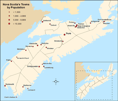
Distribution of Nova Scotia's 27 towns by population
Nova Scotia had 26 towns at the time of the 2016 Census. In 2016, the towns had a cumulative population of 97,495. Nova Scotia's largest and smallest towns are Truro and Annapolis Royal with populations of 12,261 and 491 respectively.
List
| Incorporation date[2] | 2016 Census of Population[3] | |||||
|---|---|---|---|---|---|---|
| Population (2016) | Population (2011) | Change | Land area (km²) | Population density | ||
| Amherst | December 18, 1889 | style="text-align:center;"|9,413 | 9,717 | −3.1% | 12.07 | 779.9/km2 |
| Annapolis Royal | November 29, 1892 | style="text-align:center;"|491 | 481 | +2.1% | 2.04 | 240.7/km2 |
| Antigonish | January 9, 1889 | style="text-align:center;"|4,364 | 4,524 | −3.5% | 5.01 | 871.1/km2 |
| Berwick | May 25, 1923[4] | style="text-align:center;"|2,509 | 2,454 | +2.2% | 6.58 | 381.3/km2 |
| Bridgewater | February 13, 1899 | style="text-align:center;"|8,532 | 8,241 | +3.5% | 13.63 | 626.0/km2 |
| Clark's Harbour | March 4, 1919 | style="text-align:center;"|758 | 820 | −7.6% | 2.81 | 269.8/km2 |
| Digby | December 18, 1890 | style="text-align:center;"|2,060 | 2,152 | −4.3% | 3.15 | 654.0/km2 |
| Kentville | May 1, 1886 | style="text-align:center;"|6,271 | 6,094 | +2.9% | 17.26 | 363.3/km2 |
| Lockeport | February 26, 1907 | style="text-align:center;"|531 | 588 | −9.7% | 2.33 | 227.9/km2 |
| Lunenburg | October 29, 1888 | style="text-align:center;"|2,263 | 2,313 | −2.2% | 4.04 | 560.1/km2 |
| Mahone Bay | March 31, 1919 | style="text-align:center;"|1,036 | 943 | +9.9% | 3.12 | 332.1/km2 |
| Middleton | May 31, 1909 | style="text-align:center;"|1,832 | 1,749 | +4.7% | 5.57 | 328.9/km2 |
| Mulgrave | December 1, 1923 | style="text-align:center;"|722 | 794 | −9.1% | 17.83 | 40.5/km2 |
| New Glasgow | May 6, 1875 | style="text-align:center;"|9,075 | 9,562 | −5.1% | 9.96 | 911.1/km2 |
| Oxford | April 19, 1904 | style="text-align:center;"|1,190 | 1,151 | +3.4% | 10.76 | 110.6/km2 |
| Pictou | May 4, 1874 | style="text-align:center;"|3,186 | 3,437 | −7.3% | 8.01 | 397.8/km2 |
| Port Hawkesbury | January 22, 1889 | style="text-align:center;"|3,214 | 3,366 | −4.5% | 8.1 | 396.8/km2 |
| Shelburne | April 4, 1907[5] | style="text-align:center;"|1,743 | 1,686 | +3.4% | 8.84 | 197.2/km2 |
| Stellarton | October 22, 1889 | style="text-align:center;"|4,208 | 4,485 | −6.2% | 8.99 | 468.1/km2 |
| Stewiacke | August 30, 1906 | style="text-align:center;"|1,373 | 1,438 | −4.5% | 17.62 | 77.9/km2 |
| Trenton | March 18, 1911 | style="text-align:center;"|2,474 | 2,616 | −5.4% | 6.07 | 407.6/km2 |
| Truro | May 6, 1875 | style="text-align:center;"|12,261 | 12,059 | +1.7% | 34.49 | 355.5/km2 |
| Westville | August 20, 1894 | style="text-align:center;"|3,628 | 3,798 | −4.5% | 14.23 | 255.0/km2 |
| Windsor | April 4, 1878 | style="text-align:center;"|3,648 | 3,785 | −3.6% | 9.11 | 400.4/km2 |
| Wolfville | March 4, 1893 | style="text-align:center;"|4,195 | 4,269 | −1.7% | 6.46 | 649.4/km2 |
| Yarmouth | August 6, 1890 | style="text-align:center;"|6,518 | 6,761 | −3.6% | 10.57 | 616.7/km2 |
| Total | — | 97,495 | 99,283 | −1.8% | 248.65 | 392.1/km2 |
| Province of Nova Scotia | — | 923,598 | 921,727 | +0.2% | 52,942.27 | 17.45/km2 |
Former towns
| Name | Dissolution date |
Population (2011)[6] |
Population (2006)[6] |
Change (%)[6] |
Area (km²)[6] |
Population density[6] |
|---|---|---|---|---|---|---|
| Bedford | April 1, 1996[7] | 23,019 | 16,601 | 38.7 | ||
| Bridgetown | April 1, 2015[8] | 949 | 972 | −2.4 | 3.54 | 267.8 |
| Canso | July 1, 2012[8] | 806 | 911 | −11.5 | 5.42 | 148.8 |
| Dominion | April 1, 1995[7] | 1,193 | 2,022 | −3.4 | ||
| Glace Bay | April 1, 1995[7] | 19,076 | 19,968 | −4.7 | 35.15 | 542.7 |
| Hantsport | July 1, 2015[8] | 1,159 | 1,191 | −2.7 | 2.13 | 544.6 |
| Inverness | 1,387 | 1,464 | −5.5 | |||
| Joggins | 1949[9] | |||||
| Liverpool | April 1, 1996[7] | 2,653 | 2,759 | −3.8 | 3.48 | 761.6 |
| Louisbourg | April 1, 1995[7] | 946 | 988 | −4.3 | 3.3 | 286.8 |
| New Waterford | April 1, 1995[7] | 8,942 | 9,661 | −7.4 | 20.81 | 429.7 |
| North Sydney | April 1, 1995[7] | 6,048 | 6,552 | −7.7 | ||
| Parrsboro | November 1, 2016[10] | 1,305 | 1,401 | −6.9 | 14.88 | 87.7 |
| Port Hood | August 1946[11] | |||||
| Springhill | April 1, 2015[8] | 3,868 | 3,941 | −1.9 | 11.15 | 346.8 |
| Sydney Mines | April 1, 1995[7] | 14,135 | 15,500 | −9.6 | ||
| Wedgeport | December 22, 1947[12] | 1,180 | 1,207 | −2.2 | 9.72 | 121.4 |
gollark: It's not ideal.
gollark: And AMD has the platform security processor.
gollark: I mean, all recent Intel CPUs have the Intel Management Engine, i.e. a mini-CPU with full access to everything running unfathomable code.
gollark: At some point you probably have to decide that some issues aren't really realistic or useful to consider, such as "what if there are significant backdoors in every consumer x86 CPU".
gollark: Presumably most of the data on the actual network links is encrypted. If you control the hardware you can read the keys out of memory or something (or the decrypted data, I suppose), but it's at least significantly harder and probably more detectable than copying cleartext traffic.
See also
References
- "Municipal Government Act". Office of the Legislative Counsel, Nova Scotia House of Assembly. June 19, 2012. Retrieved January 29, 2013.
- "Municipal Incorporation Timeline". Province of Nova Scotia. Retrieved December 6, 2016.
- "Population and dwelling counts, for Canada, provinces and territories, and census subdivisions (municipalities), 2016 and 2011 censuses – 100% data (Nova Scotia)". Statistics Canada. February 8, 2017. Retrieved February 11, 2017.
- Canadian Almanac & Directory. Scobie & Balfour. 2010. ISBN 1592374395.
- "Shelburne's History: Settlement of Shelburne". Town of Shelburne. Retrieved January 2, 2017.
It was incorporated as a town on April 4, 1907.
- "Population and dwelling counts, for Canada, provinces and territories, and census subdivisions (municipalities), 2011 and 2006 censuses (Nova Scotia)". Statistics Canada. December 18, 2012. Retrieved January 29, 2013.
- "Nova Scotia Annual Report of Municipal Statistics for the fiscal year ended March 31, 2014" (PDF). Department of Municipal Affairs. 2014. p. 12. Retrieved December 5, 2016.
- "Table 1: Nova Scotia, changes to Census Subdivisions in alphabetical order (with 8C & 9C) — Effective dates: From January 2nd, 2011 to January 1st, 2016". Statistics Canada. November 16, 2016. Retrieved December 6, 2016.
- The Atlantic Provinces in Confederation - edited by E.R. Forbes, D.A. Muise
- "Decision 2016 NSUARB 100 – M07110". Nova Scotia Utility and Review Board. June 15, 2016. Archived from the original on December 22, 2016. Retrieved December 28, 2016.
- How We Became a County Municipality of the County of Inverness
- "Municipal Records: Town of Wedgeport Fonds (1890-1948)". argylecourthouse.com. Retrieved January 7, 2017.
| Historical counties | |
|---|---|
| Economic regions | |
| Regional municipalities | |
| County municipalities | |
| District municipalities | |
| Towns | |
| Villages | |
| Lists | |
| |
| Provinces |
|
|---|---|
| Territories |
|
| |
This article is issued from Wikipedia. The text is licensed under Creative Commons - Attribution - Sharealike. Additional terms may apply for the media files.