List of listed buildings in Uphall, West Lothian
This is a list of listed buildings in the parish of Uphall in West Lothian, Scotland.

Uphall parish shown within West Lothian
List
| Name | Location | Date Listed | Grid Ref. [note 1] | Geo-coordinates | Notes | LB Number [note 2] | Image |
|---|---|---|---|---|---|---|---|
| Uphall Kirk. (St. Nicholas | 55°56′01″N 3°30′23″W | Category B | 14235 |  | |||
| Middleton Hall | 55°55′43″N 3°30′13″W | Category C(S) | 14242 | | |||
| Houstoun House | 55°55′33″N 3°31′04″W | Category A | 14243 | 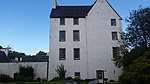 | |||
| St John Cantius And St Nicholas Roman Catholic Church And Shrine In Grounds West Main Street Broxburn | 55°56′04″N 3°28′36″W | Category B | 19222 | | |||
| Almondell Coach-House And Stables | 55°54′26″N 3°27′21″W | Category C(S) | 14227 | | |||
| Almondell Bridge | 55°54′14″N 3°27′36″W | Category A | 14228 |  | |||
| Union Canal Bridge, 28 | 55°56′27″N 3°27′50″W | Category C(S) | 14233 | | |||
| 25 And 27, 29 Ecclesmachan Road Upper Uphall | 55°56′00″N 3°30′27″W | Category C(S) | 14237 | | |||
| Crossgreen Farm 26 Ecclesmachan Road Uphall | 55°55′52″N 3°30′27″W | Category C(S) | 14239 | | |||
| Union Canal Bridge 24 Hawthorn Brae | 55°55′36″N 3°28′27″W | Category C(S) | 14230 | | |||
| Oatridge Hotel, East Main Street | 55°55′47″N 3°30′21″W | Category B | 14241 | | |||
| Uphall, 41 West Main Street | 55°55′43″N 3°30′36″W | Category C(S) | 49642 | | |||
| Union Canal Bridge, 29 | 55°56′34″N 3°27′30″W | Category C(S) | 14234 | | |||
| Union Canal Bridge 23 Drumshoreland Station Road | 55°55′32″N 3°28′05″W | Category C(S) | 14229 |  | |||
| Uphall Old Manse, Ecclesmachan Rd | 55°56′04″N 3°30′23″W | Category C(S) | 14236 | | |||
| Sundial At Houstoun House | 55°55′32″N 3°31′04″W | Category C(S) | 14244 | | |||
| Kirkhill House | 55°56′07″N 3°29′00″W | Category B | 19678 | | |||
| Astronomical Stone (In Walled Garden And Pillars, Kirkhill | 55°56′06″N 3°29′01″W | Category B | 14232 | | |||
| 28, 30 Ecclesmachan Road Uphall | 55°55′53″N 3°30′28″W | Category C(S) | 14240 | | |||
| Union Canal Bridge 25 Broxburn | 55°55′51″N 3°28′39″W | Category C(S) | 14231 | | |||
| 47 Ecclesmachan Road Upper Uphall | 55°56′07″N 3°30′26″W | Category C(S) | 14238 | | |||
| Houstoun Doocot | 55°55′33″N 3°31′01″W | Category C(S) | 14226 | | |||
| Houstoun Coach-House And Stables (Known As The Dower House) | 55°55′33″N 3°31′05″W | Category B | 14245 | |
Key
The scheme for classifying buildings in Scotland is:
- Category A: "buildings of national or international importance, either architectural or historic; or fine, little-altered examples of some particular period, style or building type."[1]
- Category B: "buildings of regional or more than local importance; or major examples of some particular period, style or building type, which may have been altered."[1]
- Category C: "buildings of local importance; lesser examples of any period, style, or building type, as originally constructed or moderately altered; and simple traditional buildings which group well with other listed buildings."[1]
In March 2016 there were 47,288 listed buildings in Scotland. Of these, 8% were Category A, and 50% were Category B, with the remaining 42% being Category C.[2]
Notes
- Sometimes known as OSGB36, the grid reference (where provided) is based on the British national grid reference system used by the Ordnance Survey.
• "Guide to National Grid". Ordnance Survey. Retrieved 2007-12-12.
• "Get-a-map". Ordnance Survey. Retrieved 2007-12-17. - Historic Environment Scotland assign a unique alphanumeric identifier to each designated site in Scotland, for listed buildings this always begins with "LB", for example "LB12345".
gollark: Even if they originally had it.
gollark: Once someone else has the key for your address, no security for you.
gollark: <@122723328443154434> Oh, also, GPU-accelerated address mining was tried, I believe, and failed, because it was hard to parallelize.
gollark: It looks like `gpu.js` relies on some sort of hackery involving writing to a texture to do its computing.
gollark: Yes.
References
- All entries, addresses and coordinates are based on data from Historic Scotland. This data falls under the Open Government Licence
- "What is Listing?". Historic Environment Scotland. Retrieved 29 May 2018.
- Scotland's Historic Environment Audit 2016 (PDF). Historic Environment Scotland and the Built Environment Forum Scotland. pp. 15–16. Retrieved 29 May 2018.
This article is issued from Wikipedia. The text is licensed under Creative Commons - Attribution - Sharealike. Additional terms may apply for the media files.