List of listed buildings in Kirknewton, West Lothian
This is a list of listed buildings in the parish of Kirknewton in West Lothian, Scotland.
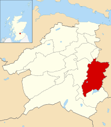
Kirknewton parish shown within West Lothian
List
| Name | Location | Date Listed | Grid Ref. [note 1] | Geo-coordinates | Notes | LB Number [note 2] | Image |
|---|---|---|---|---|---|---|---|
| Old Linburn House Sundial In Walled Garden | 55°53′57″N 3°24′25″W | Category B | 7359 |  | |||
| Ainville Farm-House | 55°51′25″N 3°25′41″W | Category B | 7363 | | |||
| Kirknewton, Station Road, Parish Church (Church Of Scotland) And Halls Including Boundary Walls | 55°53′17″N 3°25′52″W | Category C(S) | 50535 | 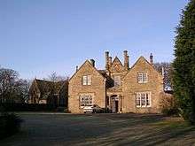 | |||
| Hill House | 55°53′22″N 3°24′41″W | Category B | 7352 | | |||
| South Gateway Hatton Estate | 55°54′04″N 3°23′46″W | Category A | 7355 | 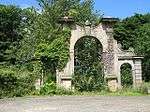 | |||
| East Calder Village St. Cuthbert's Church | 55°53′41″N 3°27′58″W | Category B | 7366 | 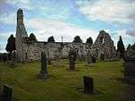 | |||
| 2, 4 Smithybrae | 55°53′15″N 3°25′07″W | Category C(S) | 7383 | | |||
| Ormiston Hill House | 55°52′56″N 3°26′22″W | Category C(S) | 13646 | | |||
| South Gate-Way Almondell Park | 55°53′51″N 3°27′19″W | Category B | 7369 | | |||
| Maconochies Of Meadowbank Burial Enclosure Kirknewton Burial Ground | 55°53′15″N 3°25′04″W | Category B | 7384 | | |||
| Merivil Cottage | 55°53′40″N 3°28′01″W | Category B | 13647 | | |||
| Ormiston House | 55°53′02″N 3°26′29″W | Category B | 7358 | | |||
| Leithhead Farm, By The Water Of Leith | 55°51′27″N 3°25′01″W | Category C(S) | 7364 | | |||
| Kirknewton, Easter Colzium | 55°48′44″N 3°27′55″W | Category C(S) | 43570 | | |||
| Kirknewton Station, Station House | 55°53′21″N 3°26′01″W | Category B | 13466 | | |||
| Lodges, 19 And 21 Whitemoss Road, And Gate, Kirknewton Village | 55°53′10″N 3°25′09″W | Category B | 7348 | | |||
| Waterloo Tower | 55°53′40″N 3°23′58″W | Category B | 7354 | | |||
| Bridge Gogar Burn, Ormiston Estate | 55°53′04″N 3°26′25″W | Category C(S) | 7361 | | |||
| Railway Viaduct, Linhouse Water | 55°52′03″N 3°28′37″W | Category A | 7365 | 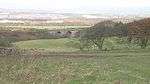 | |||
| Dr. Cullen Burial Enclosure | 55°53′15″N 3°25′03″W | Category B | 7351 | 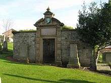 | |||
| Easter Newton Farm-House | 55°53′17″N 3°24′14″W | Category B | 7353 | | |||
| Millrigg Farmhouse | 55°53′26″N 3°26′25″W | Category B | 7357 | | |||
| 14, 16, 18, 20, 22 And 24 Main Street | 55°53′16″N 3°25′08″W | Category C(S) | 7382 | | |||
| Kirknewton, Station Road, The Old School House | 55°53′17″N 3°25′51″W | Category C(S) | 50536 | | |||
| Ormiston Mains Steading | 55°53′18″N 3°26′26″W | Category C(S) | 7360 | | |||
| Raw Farm-House | 55°53′49″N 3°26′59″W | Category C(S) | 7367 | | |||
| Overshiel Farm-House | 55°54′15″N 3°26′28″W | Category B | 7368 | | |||
| Canal Feeder Aqueduct, River Almond | 55°54′04″N 3°27′46″W | Category A | 7371 | | |||
| Mineral Railway Viaduct, River Almond | 55°54′00″N 3°27′47″W | Category B | 7372 | | |||
| 'sawmill House', 5 Whitemoss Road | 55°53′14″N 3°25′11″W | Category C(S) | 7381 | | |||
| East Gate-Lodge And Gate-Way Linburn Park | 55°54′03″N 3°23′59″W | Category B | 7356 | | |||
| Kirknewton House | 55°53′00″N 3°24′57″W | Category B | 7362 | | |||
| Almondell Bridge, River Almond | 55°54′14″N 3°27′36″W | Category A | 7370 |  | |||
| Raw Camps Lime Kilns | 55°54′00″N 3°26′49″W | Category B | 7373 | |
Key
The scheme for classifying buildings in Scotland is:
- Category A: "buildings of national or international importance, either architectural or historic; or fine, little-altered examples of some particular period, style or building type."[1]
- Category B: "buildings of regional or more than local importance; or major examples of some particular period, style or building type, which may have been altered."[1]
- Category C: "buildings of local importance; lesser examples of any period, style, or building type, as originally constructed or moderately altered; and simple traditional buildings which group well with other listed buildings."[1]
In March 2016 there were 47,288 listed buildings in Scotland. Of these, 8% were Category A, and 50% were Category B, with the remaining 42% being Category C.[2]
Notes
- Sometimes known as OSGB36, the grid reference (where provided) is based on the British national grid reference system used by the Ordnance Survey.
• "Guide to National Grid". Ordnance Survey. Retrieved 2007-12-12.
• "Get-a-map". Ordnance Survey. Retrieved 2007-12-17. - Historic Environment Scotland assign a unique alphanumeric identifier to each designated site in Scotland, for listed buildings this always begins with "LB", for example "LB12345".
gollark: There is one, yes.
gollark: They're highly lasery.
gollark: Via orbital criticism lasers.
gollark: I am allowed to criticize anything for any reason whatsoever.
gollark: This is because NSFW stuff is generally considered more beeser than discussing religion generally.
References
- All entries, addresses and coordinates are based on data from Historic Scotland. This data falls under the Open Government Licence
- "What is Listing?". Historic Environment Scotland. Retrieved 29 May 2018.
- Scotland's Historic Environment Audit 2016 (PDF). Historic Environment Scotland and the Built Environment Forum Scotland. pp. 15–16. Retrieved 29 May 2018.
This article is issued from Wikipedia. The text is licensed under Creative Commons - Attribution - Sharealike. Additional terms may apply for the media files.