List of axial five-stone circles
An axial five-stone circle is a particular type of megalithic ring of five stones of which many are found in southwest Ireland. These circles have an approximate axis of symmetry aligned in a generally northeast–southwest direction – the stone at the southwest side of the circle, rather than being an upright orthostat like the rest, rests on the ground with its long axis horizontal. Because it marks the axis it is called the axial stone. It is usually quite thin and it lies with its long thin edge along the circumference of the ring.[1][2]
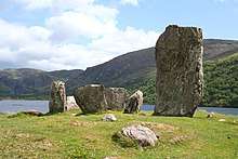
There are two types of axial stone circle, one type with five stones, listed here, and axial multiple-stone circles, with seven stones or more, listed at List of axial multiple-stone circles. Dating from the Bronze Age, these circles when constructed had an odd number of stones with two stones (portal stones) placed on either side of where the axis crosses the northeast side of the ring. They are found in County Cork and County Kerry.[3][4][5]
Early in the 20th century this type of circle was called a recumbent stone circle by analogy with similar examples in Scotland but when it became clear there were substantial differences the term "Cork–Kerry stone circle" was used for both types until later the term "axial stone circle" became commonly used.[6]
Ó Nualláin (1984) has published a comprehensive catalogue of stone circles in the two counties and Burl followed with two books, Burl (1995) and Burl (2000), covering a much broader area but still including this type of circle. Ireland's National Monuments Service, part of the Department of Culture, Heritage and the Gaeltacht, operates a database of archaeology sites and the list in this article covers the sites classified as "stone circle – five-stone".[7] The NMS definition is:
Stone circle - five-stone
A distinctive form of stone circle found only in counties Cork and Kerry. It comprises a ring of five free-standing stones, symmetrically arranged so that one stone, the axial stone, is set directly opposite two stones, usually the tallest, marking the entrance to the circle. Characteristically, the stones reduce in height to the axial stone, which is set consistently in the south-western part of the circle. These circles are thought to have a ritual function and are dated to the Bronze Age (c. 2400-500 BC).
— Class List Definitions, "Stone circle - five-stone". National Monuments Service: Archaeological Survey of Ireland.
Included are 56 sites in County Cork and three in County Kerry.[7]
List of axial five-stone circles

The map shows the locations of the 56 sites in counties Cork and Kerry. All the locations can be displayed dynamically via the OpenStreetMap viewer.
| Townland[n 1] | SMR No.[n 2] | Ref.[n 3] | Diameter (metre)[n 4] |
Num. stones[n 5] | Status[n 6] Notes |
Lat/long[n 7] | Irish Grid[n 8] |
|---|---|---|---|---|---|---|---|
| An Lománach Mhór Lumnagh More | CO069-076---- | - | 2.1[7] | 5/5[7] | 51.924°N 9.247°W | W 142 753 | |
| Ballyvouskill | CO048-056---- | none C5 | 3.5 | 5/5[7] | ruin | 52.012°N 9.087°W | W 254 849 |
| Baurgorm (N) | CO118-044002- | 303A C6a (85 16) | 2.6 | 5/5 | ruin | 51.667°N 9.413°W | W 023 469 |
| Baurgorm (S) | CO118-042---- | 303B C6b (86 15) | 2.6x2.5 | 5/5 | ruin | 51.658°N 9.424°W | W 015 459 |
| Bellmount Upper (N) | CO083-118---- | none C7a (73 15) | 4 | 5/5[7] | gone | 51.828°N 8.828°W | W 429 642 |
| Bellmount Upper (S) | CO083-117---- | none C7b (74 15) | 3.9 | 5/5 | gone | 51.827°N 8.831°W | W 427 641 |
| Cabragh | CO059-015002- | none C11 (63 18) | 3.2 | 4/5 | ruin | 51.967°N 9.051°W | W 278 798 |
| Canrooska | CO090-006002- | none C12 (76 20) | 2.4 | 4/5 | ruin | 51.766°N 9.543°W | V 935 582 |
| Cappaboy Beg (NW) | CO092-004---- | 306 C13a (77 15) | 2.3x1.8 | 5/5 | ruin | 51.796°N 9.333°W | W 081 612 |
| Carrigagrenane (NE) | CO121-054---- | 308 C15a (91 18) | 4/5 | ruin | 51.641°N 9.071°W | W 259 436 | |
| Carrigagulla (NE) | CO049-007---- | 309 C16a (56 15) | 3 | 2+/5 | ruin | 52.003°N 8.915°W | W 372 838 |
| Carriganimmy | CO048-097001- | 311 C17 (55 16) | 3.3 | 5/5 | good | 51.992°N 9.03°W | W 292 826 |
| Carriganine | CO070-092---- | none C18 (69 18) | 5/5 | unc. | 51.896°N 8.981°W | W 325 719 | |
| Carrigonirtane | CO059-011---- | none C20 | 2.8 | 4/5 | ruin | 51.974°N 9.04°W | W 285 806 |
| Cashelkeelty (E) | KE108-013004- | 344 K1b (93 17) | 1.5 | 3/5[7] | ruin | 51.757°N 9.814°W | V 748 575 |
| Clodagh | CO120-001002- | 312 C21 (88 18) | 2.7 | 5/5 | good | 51.696°N 9.225°W | W 153 499 |
| Cloghboola Beg | CO048-080002- | 313 C22 (53 19) | 3.9x2.8 | 5/5[7] | ruin | 52.015°N 9.012°W | W 305 852 |
| Cloghboola More | CO048-025001- | none C23 (52 15) | 3.1 | 4/5 | ruin | 52.03°N 9.056°W | W 275 869 |
| Cousane | CO092-051---- | 314 C27 (79 15) | 3.2x2.4 | 5/5 | good | 51.756°N 9.287°W | W 112 567 |
| Cullenagh | CO107-024---- | none C28 | 2/5[7] | ruin | 51.714°N 9.23°W | W 150 519 | |
| Cullomane East | CO118-073001- | 315 C29 (84 15) | 3.9x3.4 | 5/5 | good | 51.653°N 9.393°W | W 036 453 |
| Derryarkane | CO106-019---- | none C34 | 3 | 5/5[7] | good | 51.728°N 9.373°W | W 051 536 |
| Dromatouk | KE093-087---- | 345 K4 (92 15) | 2.7 | 5/5 | good | 51.883°N 9.526°W | V 949 711 |
| Dromgarriff South | CO051-153---- | none C37 (60 23) | 3 | 0/5 | gone | 51.991°N 8.549°W | W 623 822 |
| Dromgarvan | CO116-006---- | none C38 (83 15) | 3x2.4 | 5/5 | ruin | 51.692°N 9.725°W | V 808 501 |
| Glanbrack | CO121-059001- | none C42 (90 16) | 2.8 | 3/5 | ruin | 51.648°N 9.053°W | W 271 444 |
| Glenleigh | CO039-097---- | none C45 (50 15) | 3.4 | 4/5[7] | ruin | 52.061°N 8.995°W | W 318 903 |
| Glenreagh | CO021-060---- | none C46 (49 16) | 3.5 | 4/5 | ruin | 52.176°N 9.186°W | R 189 033 |
| Gort Na Tiobratan Gortnatubbrid | CO058-029---- | none C51 (61 15) | 2.4 | 4/5 | ruin | 51.93°N 9.173°W | W 193 758 |
| Grenagh South | CO051-103---- | none C54 (59 23) | 5 | 0/5 | gone | 52.007°N 8.629°W | W 568 840 |
| Illane | CO092-016001- | none C55 (78 20) | 2.7x2.3 | 5/5 | ruin | 51.78°N 9.383°W | W 045 595 |
| Inchireagh | CO107-012---- | none C56 (82 17) | 3x2.4 | 5/5 | ruin | 51.754°N 9.174°W | W 189 563 |
| Inchybegga | CO119-032---- | none C57 (87 17) | 3x2.7 | 4/5 | ruin | 51.659°N 9.376°W | W 048 460 |
| Kealkill | CO106-006001- | 323 C59 (81 20) | 2.8x2.5 | 5/5[7] | good | 51.745°N 9.371°W | W 053 555 |
| Kilmeedy West (E) | CO039-242---- | - | 1.6[7] | 4/5[7] | 52.044°N 9.1°W | W 245 885 | |
| Kilmeedy West (W) | CO047-005---- | none C62 | 3.5 | 3/5[7] | ruin | 52.041°N 9.11°W | W 238 881 |
| Knockantota North | CO051-018---- | none C63 | 0/5 | gone | 52.039°N 8.645°W | W 558 875 | |
| Knockavullig (N) | CO071-106---- | none C65a (71 17) | 2.4x2.3 | 0/5 | gone | 51.884°N 8.829°W | W 429 704 |
| Knockavullig (S) | CO071-068---- | none C65b (72 17) | 3.2 | 5/5 | ruin | 51.882°N 8.831°W | W 428 702 |
| Knocknakilla | CO048-095002- | 324 C66 (54 19) | 2.7 | 5/5[7] | good | 52.006°N 9.024°W | W 297 842 |
| Knocknaneirk (NE) | CO083-085002- | none C67a (75 16) | 3.9x3.1 | 5/5 | good | 51.818°N 8.914°W | W 370 631 |
| Knockraheen | CO059-023002- | 325 C68 (62 18) | 4.1x3.6 | 5/5 | good | 51.969°N 9.013°W | W 304 801 |
| Laharankeal | CO060-137---- | none C37 (64 17) | 1.5 | 5/5 | ruin | 51.944°N 8.881°W | W 394 772 |
| Leckaneen | CO061-084---- | none C72 (66 17) | 3.5 | 5/5 | ruin | 51.941°N 8.815°W | W 440 768 |
| Lettergorman (SW) | CO121-035---- | 326 C73b (89 17) | 3.1x2.8 | 5/5 | ruin | 51.658°N 9.067°W | W 262 455 |
| Lissacresig | CO070-016---- | 328 C74 (r 17) | 3.6x3 | 5/5 | good | 51.925°N 9.062°W | W 270 752 |
| Maughanaclea centre | CO106-014001- | none C76a | 2.6x2.2 | 5/5[7] | ruin | 51.752°N 9.32°W | W 089 562 |
| Mill Little | CO105-004004- | 332 C78 (80 18) | 3.1x2.4 | 5/5 | ruin | 51.753°N 9.464°W | V 989 566 |
| Oughtihery (NW) | CO049-029---- | 333 C79b (57 17) | 2.9x2.7 | 5/5[7] | ruin | 51.988°N 8.888°W | W 390 821 |
| Pluckanes North | CO051-043001- | none C80 (58 22) | 3.7x3.2 | 0/5 | gone | 52.012°N 8.677°W | W 535 845 |
| Ré Na Ndoirí Reananerre | CO069-026---- | 336 C81 (67 17) | 2.6x1.9 | 5/5 | good | 51.903°N 9.158°W | W 203 729 |
| Rosnascalp | CO071-100---- | none C83 (70 17) | 3 | 5/5 | ruin | 51.886°N 8.899°W | W 381 707 |
| Rylane | CO061-001---- | 337 C84 (65 16) | 3.7x2.9 | 5/5 | good | 51.982°N 8.817°W | W 438 813 |
| Trawlebane | CO119-005---- | none C87 | 2.4 | 5/5[7] | ruin | 51.674°N 9.386°W | W 042 477 |
| Tullig | CO048-044---- | none C88 (51 none) | 0/5 | gone | 52.036°N 9.007°W | W 309 876 | |
| Uragh (NE) | KE101-012001- | none K19a | 2.5x2.4 | 5/5[7] | 51.811°N 9.696°W | V 831 634 |
See also
Notes
- The county is indicated in the first two letters of the SMR number. All are in County Cork or County Kerry.
- Sites and Monuments Record number allocated by National Monuments Service.
- Top line: number of site in Burl (1995, pp. 212–235) ("none" if not included). Then, number in Burl (2000, pp. 397–401) county listing with C and K for Cork or Kerry. Second line in parentheses: reference number and figure number, both linked to the page numbers in Ó Nualláin (1984).
- Internal length in metres along the axis from Burl (2000) unless otherwise noted. Where two lengths are given (for an oval ring) they are for along and across the axis.
- Number of stones including the axial stone expressed as x/y where x is the number of stones remaining (including fallen ones) and y is the number originally present From Ó Nualláin (1984, pp. 4–5) unless otherwise stated.
- Burl (1995) and Burl (2000) classifies the sites as follows 1 (good) = Good, worth visiting; 2 (OK) = Good but restored; 3 (ruin) = Ruined but recognisable; 4 (gone) = Destroyed or unrecognisable; 5 (unc.) = Uncertain.
- Latitude/ longitude calculated from NMS Irish grid coordinates using Irish Grid Reference Finder.[7][8]
- Irish Grid reference conversion from NMS Irish grid coordinates using Irish Grid Reference Finder.[7][8]
References
Citations
- Ó Nualláin (1975), pp. 83–84.
- Burl (2000), pp. 264, 271.
- Scarre, Christophe (2002). Monuments and Landscape in Atlantic Europe: Perception and Society During the Neolithic and Early Bronze Age. Psychology Press. pp. 154–155. ISBN 978-0-415-27314-5.
- Burl (2000), pp. 262-271.
- Burl (2000), pp. 258, 262–265.
- Ó Nualláin (1975), pp. 84–85.
- NMS Historical Environment Viewer.
- "Irish Grid Reference Finder". irish.gridreferencefinder.com. Archived from the original on 9 December 2019. Retrieved 28 February 2020.
Works cited
- Burl, Aubrey (1995). A Guide to the Stone Circles of Britain, Ireland, and Brittany. Yale University Press. ISBN 0-300-06331-8.
- Burl, Aubrey (2000). The Stone Circles of Britain, Ireland, and Brittany. Yale University Press. ISBN 0-300-08347-5.
- National Monuments Service. "Historical Environment Viewer". Archaeological Survey of Ireland.
- Ó Nualláin, Seán (1975). "The Stone Circle Complex of Cork and Kerry". Journal of the Royal Society of Antiquaries of Ireland. 105: 83–131. JSTOR 25508668.
- Ó Nualláin, Seán (1984). "A Survey of Stone Circles in Cork and Kerry". Proceedings of the Royal Irish Academy. Section C: Archaeology, Celtic Studies, History, Linguistics, Literature. 84C: 1–77. JSTOR 25506112.
Further reading
- Ó Ríordáin, Seán P (1939). "Excavation of a stone circle and cairn at Kealkil, Co. Cork" (PDF). Journal of the Cork Historical & Archaeological Society, series 2. 44 (159): 46–49. – excavation of Kealkill
- Lynch, Ann (1981). Man and Environment in South-west Ireland 4000B.C.-A.D.800. B85. British Archaeological Reports: British Series. pp. 65–69. ISBN 978-0860541127. – excavation of Cashelkeelty