List of National Natural Landmarks in New Mexico
From List of National Natural Landmarks, these are the National Natural Landmarks in New Mexico. There are 12 in total.

Bitter Lake Group
Grants Lava Flow
Mescalero Sands South Dune
Border Hills Structural Zone
New Mexico National Natural Landmarks (clickable map)
| Name | Image | Date | Location | County | Ownership | Description | |
|---|---|---|---|---|---|---|---|
| 1 | Border Hills Structural Zone | 1980 | 33.367226°N 104.948359°W | Lincoln | federal (Bureau of Land Management) | A rare example of wrench faulting outside the Pacific Coast region. | |
| 2 | Bitter Lake Group | 1980 | 33.456047°N 104.401621°W | Chaves | federal (Bitter Lake National Wildlife Refuge) | Saline artesian lakes that provide habitat for the only inland occurrence of a marine alga and two rare fish species. | |
| 3 | Bueyeros Shortgrass Plains | 1980 | Harding | private | An example of the blue grama-buffalograss prairie of the Great Plains. | ||
| 4 | Fort Stanton Cave | 1980 | 33.499099°N 105.523798°W | Lincoln | federal (Fort Stanton – Snowy River Cave National Conservation Area) | Cave containing distinctive examples of selenite needles, starbursts, and velvet flowstone. | |
| 5 | Grants Lava Flow | 1969 | 34.888718°N 107.993472°W | Valencia | federal (El Malpais National Conservation Area) & native (Acoma Pueblo) | One of the best examples of recent extrusive volcanism. | |
| 6 | Ghost Ranch | 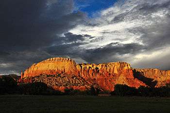 |
1975 | 36.329789°N 106.474°W | Rio Arriba | private | Fossil site where well-preserved Coelophysis skeletons were found. |
| 7 | Kilbourne Hole | 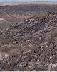 |
1975 | 31.971944°N 106.964722°W | Doña Ana | federal (Bureau of Land Management) | An example of an uncommon volcanic feature known as a maar. |
| 8 | Mathers Research Natural Area | 1980 | Chaves | federal (Bureau of Land Management) | The best example of a shinnery oak-sand prairie community in the southern Great Plains. | ||
| 9 | Mescalero Sands South Dune | 1982 | 33.416122°N 103.869842°W | Chaves | federal (Bureau of Land Management) | The best example of an active sand dune system in the southern Great Plains. | |
| 10 | Ship Rock | 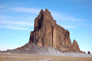 |
1975 | 36.6875°N 108.836389°W | San Juan | native (Navajo Nation) | An outstanding example of an exposed volcanic neck accompanied by radiating dikes. |
| 11 | Torgac Cave | 1974 | Lincoln | federal (Bureau of Land Management) | Cave with distinctive branching stalactites and helictites, the type site of Torgac-type helictites. | ||
| 12 | Valles Caldera | 1975 | 35.9°N 106.533333°W | Rio Arriba, Sandoval | federal (Valles Caldera National Preserve) | One of the largest calderas in the world. | |
This article is issued from Wikipedia. The text is licensed under Creative Commons - Attribution - Sharealike. Additional terms may apply for the media files.