List of Cultural Properties of Japan - structures (Miyagi)
This list is of the Cultural Properties of Japan designated in the category of structures (建造物, kenzōbutsu) for the Prefecture of Miyagi.[1]
National Cultural Properties
As of 1 August 2015, twenty Important Cultural Properties (including three *National Treasures) with forty-two component structures have been designated, being of national significance.[2][3][4]
| Property | Date | Municipality | Comments | Image | Coordinates | Ref. |
|---|---|---|---|---|---|---|
| *Zuigan-ji Kuri and Corridor 瑞巖寺庫裏及び廊下 Zuiganji kuri oyobi rōka | 1609 | Matsushima | designation comprises two components |  | 38°22′20″N 141°03′37″E | |
| *Zuigan-ji Hondō 瑞巖寺本堂(元方丈) Zuiganji hondō (moto hōjō) | 1609 | Matsushima | formerly the hōjō | 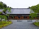 | 38°22′20″N 141°03′34″E | |
| *Ōsaki Hachimangū 大崎八幡宮 Ōsaki Hachimangū | 1607 | Sendai | 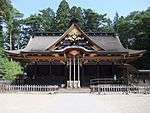 | 38°16′21″N 140°50′42″E | ||
| Agatsuma Family Residence 我妻家住宅 Agatsuma-ke jūtaku | mid/late Edo period | Zaō | designation comprises four components: the main building (1753), and three storehouses (1805, 1810, 1751-1829) | 38°05′00″N 140°39′09″E | ||
| Former Satō Family Residence 旧佐藤家住宅 kyū-Satō-ke jūtaku | mid/late Edo period | Kakuda | 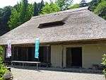 | 37°59′58″N 140°43′05″E | ||
| Former Nakazawa Family Residence 旧中澤家住宅 kyū-Nakazawa-ke jūtaku | mid/late Edo period | Natori | 38°09′46″N 140°52′10″E | |||
| Former Tome Kōtō Jinjō Junior School Building 旧登米高等尋常小学校校舎 kyū-Tome kōtō jinjō shōgakkō kōsha | 1888 | Tome | now the Toyoma Education Museum | 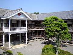 | 38°39′19″N 141°16′47″E | |
| Kōzō-ji Amida-dō 高蔵寺阿弥陀堂 Kōzōji Amidadō | 1177 | Kakuda | 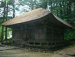 | 38°00′00″N 140°43′06″E | ||
| Former Matsumoto Family Residence 松本家住宅 kyū-Matsumoto-ke jūtaku | mid/late Edo period | Kami | 38°34′32″N 140°46′00″E | |||
| Zuigan-ji Godaidō 瑞巖寺五大堂 Zuiganji godaidō | 1604 | Matsushima | 38°22′11″N 141°03′51″E | |||
| Zuigan-ji Onarimon 瑞巖寺御成門 Zuiganji onarimon | 1609 | Matsushima |  | 38°22′18″N 141°03′35″E | ||
| Zuigan-ji Chūmon 瑞巖寺中門 Zuiganji chūmon | 1609 | Matsushima | 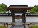 | 38°22′18″N 141°03′35″E | ||
| Ishii Lock 石井閘門 Ishii kōmon | 1880 | Ishinomaki | 38°26′48″N 141°17′28″E | |||
| Ōsaki Hachimangū Nagatoko 大崎八幡宮長床 Ōsaki Hachimangū nagatoko | 1661-1672 | Sendai | 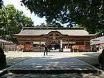 | 38°16′20″N 140°50′42″E | ||
| Tōshōgū 東照宮手水舎 Tōshōgū | 1654 | Sendai | designation comprises five components: the honden, karamon, sukibei (fence), zuijinmon, and torii | 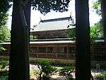 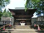 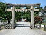 | 38°16′49″N 140°53′06″E | |
| Horaguchi Family Residence 洞口家住宅 Horaguchi-ke jūtaku | 1750/60s | Natori | 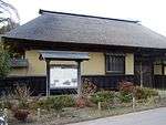 | 38°10′22″N 140°54′55″E | ||
| Yōtoku-in Tamaya 陽徳院霊屋 Yōtoku-in tamaya | 1660 | Matsushima | Mausoleum of Date Masamune's wife Megohime | 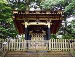 | 38°22′24″N 141°03′37″E | |
| Mutsu Kokubun-ji Yakushidō Niōmon 陸奥国分寺薬師堂 Mutsu Kokubunji Yakushidō Niōmon | 1607 | Sendai | 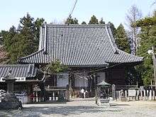 | 38°15′05″N 140°54′10″E | ||
| Entsū-in Tamaya 圓通院霊屋 Entsū-in tamaya | 1647 | Matsushima | 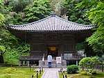 | 38°22′17″N 141°03′35″E | ||
| Shiogama Jinja 鹽竈神社 Shiogama Jinja | 1647 | Shiogama | designation comprises fifteen components: the torii and sayūgū and betsugū haiden of 1663; and sagū, ugū, and betsugū honden, sagū, ugū, and betsugū heiden, sayūgū and betsugū kairō, sayūgū and betsugū mizugaki, gate and kairō, and zuijinmon, all of 1704 | 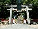 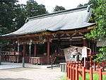 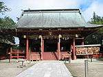 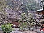 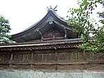 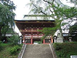 | 38°19′09″N 141°00′46″E | |
Prefectural Cultural Properties
As of 1 May 2014, thirty-six properties have been designated at a prefectural level.[4][5]
| Property | Date | Municipality | Comments | Image | Coordinates | Ref. |
|---|---|---|---|---|---|---|
| Kanrantei 観瀾亭 Kanrantei | 1592-1596 | Matsushima | built for Hideyoshi's Fushimi Castle, transferred to Edo by Date Masamune, and then to Matsushima by Date Tadamune | 38°22′10″N 141°03′41″E | ||
| Hakusan Jinja Honden 白山神社本殿 Hakusan Jinja honden | 1640 | Sendai | with shingle roof since 1668 | _honden.JPG) | 38°14′45″N 140°54′03″E | |
| Kakujō-ji Tamaya 覚乗寺高台院霊屋 Kakujōji tamaya | 1672 | Tome | 38°39′29″N 141°16′53″E | |||
| Arikabe Honjin 有壁本陣 Arikabe honjin | 1744 | Kurihara | 38°52′04″N 141°07′28″E | |||
| Suwa Jinja Honden 諏訪神社本殿 Suwa Jinja honden | c.1705 | Sendai | 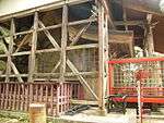 | 38°15′56″N 140°45′31″E | ||
| Tōshōgū Chōzuya 東照宮手水舎 Tōshōgū chōzuya | 1654 | Sendai | 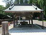 | 38°16′49″N 140°53′06″E | ||
| Kamo Jinja Honden 賀茂神社本殿 Kamo Jinja honden | 1696-7 | Sendai | the Shimogamo honden dates to 1696, Kamigamo to 1697 | 38°19′16″N 140°50′57″E | ||
| Ōsaki Hachimangū Stone Torii 大崎八幡宮石鳥居 Ōsaki Hachimangū ishi-torii | 1668 | Sendai | repaired in 1907 | 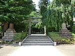 | 38°16′20″N 140°50′42″E | |
| Kōrin-ji Sanmon 香林寺山門 Kōrinji sanmon | 1584 | Tome | 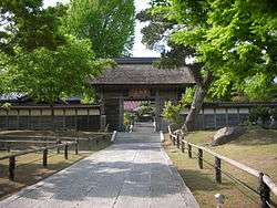 | 38°36′08″N 141°15′34″E | ||
| Mutsu Kokubun-ji Yakushidō Niōmon 陸奥国分寺薬師堂仁王門 Mutsu Kokubunji Yakushidō Niōmon | 1607 | Sendai | 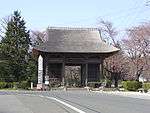 | 38°15′05″N 140°54′10″E | ||
| Kannari Junior School Building 金成小学校校舎 Kannari shōgakkō kōsha | 1887 | Kurihara | remodelled in 1910; now the Kurihara City Kannari Museum of History and Folklore (栗原市金成歴史民俗資料館) | 38°48′40″N 141°04′26″E | ||
| Zuigan-ji Sōmon 瑞巌寺総門 Zuiganji sōmon | early Edo period | Matsushima |  | 38°22′20″N 141°03′35″E | ||
| Former Tome Police Station 旧登米警察署庁舎 kyū-Tome keisatsusho chōsha | 1888 | Tome | now the Police Museum (警察資料館) | 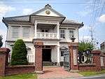 | 38°39′29″N 141°16′23″E | |
Municipal Cultural Properties
As of 1 May 2014, one hundred and twenty properties have been designated at a municipal level.[6]
| Property | Date | Municipality | Comments | Image | Coordinates | Ref. |
|---|---|---|---|---|---|---|
| Dainen-ji Sōmon 大年寺惣門 Dainenji sōmon | Edo period | Sendai | 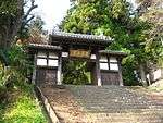 | 38°14′13″N 140°52′44″E | ||
| Jōkaku-ji Sanmon 成覚寺山門(旧浄眼院殿霊屋門) Jōkakuji sanmon (kyū-Jōgan-in den tamaya mon) | 1687 | Sendai | 38°15′18″N 140°53′21″E | |||
| Rinnō-ji Sanmon 輪王寺山門 Rinnōji sanmon | 1691 | Sendai | 38°17′00″N 140°51′33″E | |||
Registered Cultural Properties
As of 1 August 2015, ninety-seven properties at thirty-three sites have been registered (as opposed to designated) at a national level.[7][8]
| Property | Date | Municipality | Comments | Image | Coordinates | Ref. |
|---|---|---|---|---|---|---|
| Ōsaki Hachimangū Shamusho 大崎八幡宮社務所 Ōsaki Hachimangū shamusho | late Taishō period | Sendai | 38°16′18″N 140°50′40″E | |||
| Ōsaki Hachimangū Former Chief Priest's Quarters 大崎八幡宮旧宮司宿舎 Ōsaki Hachimangū kyū-gūji shukusha | late Taishō period | Sendai | 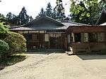 | 38°16′17″N 140°50′40″E | ||
| Ōsaki Hachimangū Shinmesha 大崎八幡宮神馬舎 Ōsaki Hachimangū shinmesha | late Taishō period | Sendai | renovated in 2010 | 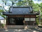 | 38°16′18″N 140°50′43″E | |
Cultural Properties of Japan - structures | ||
|---|---|---|
| National Treasures |
|    |
| Important Cultural Properties |
| |
| Hokkaidō | ||
| Tōhoku |
| |
| Kantō |
| |
| Chūbu |
| |
| Kansai |
| |
| Chūgoku |
| |
| Shikoku | ||
| Kyūshū |
| |
| Okinawa | ||
1 | ||
gollark: You "verified" your bot!? Totally apioformic.
gollark: Suspicious.
gollark: There are strict rules.
gollark: Amateur radio licenses don't let you just transmit ANYTHING on amateur bands.
gollark: Or at least they don't care much and can't enforce it.
See also
- Cultural Properties of Japan
- National Treasures of Japan
- List of Historic Sites of Japan (Miyagi)
- List of Cultural Properties of Japan - paintings (Miyagi)
References
- "Pamphlet on Cultural Properties". Agency for Cultural Affairs. Retrieved 3 August 2015.
- 国宝・重要文化財 [Number of National Treasures and Important Cultural Properties by Prefecture] (in Japanese). Agency for Cultural Affairs. 1 August 2015. Retrieved 3 August 2015.
- "Database of National Cultural Properties: 国宝・重要文化財(建造物) (宮城県)" (in Japanese). Agency for Cultural Affairs. Archived from the original on 4 December 2015. Retrieved 3 August 2015.
- 宮城県の国・県指定文化財 [National and Prefectural Cultural Properties of Miyagi Prefecture] (in Japanese). Miyagi Prefecture. 9 July 2012. Archived from the original on 12 January 2013. Retrieved 3 August 2015.
- 都道府県別指定等文化財件数(都道府県分) [Number of Prefectural Cultural Properties by Prefecture] (in Japanese). Agency for Cultural Affairs. 1 May 2014. Retrieved 3 August 2015.
- 都道府県別指定等文化財件数(市町村分) [Number of Municipal Cultural Properties by Prefecture] (in Japanese). Agency for Cultural Affairs. 1 May 2014. Retrieved 3 August 2015.
- 登録文化財 [Number of Registered Cultural Properties by Prefecture] (PDF) (in Japanese). Agency for Cultural Affairs. 1 August 2015. Retrieved 3 August 2015.
- 宮城県の国登録文化財一覧表 [List of Registered Cultural Properties of Miyagi Prefecture] (in Japanese). Miyagi Prefecture. 16 August 2012. Archived from the original on 24 September 2015. Retrieved 3 August 2015.
External links
- (in Japanese) Cultural Properties in Miyagi Prefecture
This article is issued from Wikipedia. The text is licensed under Creative Commons - Attribution - Sharealike. Additional terms may apply for the media files.