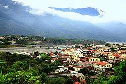
Liouguei District, Kaohsiung
Liouguei District[2][3][4][5][6][7][8][9] (Taivoan: Lakuri[10]; Chinese: 六龜區; Hanyu Pinyin: Liùguī Qū; Tongyong Pinyin: Liòuguei Cyu; Wade–Giles: Liu4-kuei1 Ch'ü1) is a rural district of Kaohsiung City, Taiwan. It is the third largest district in Kaohsiung City after Tauyuan District and Namasia District. The place-name is derived from the name of a Taivoan community Lakuri or Lakkuli, which emigrated from Vogavon in Tainan, driven to Kaohsiung by the invasion of Han immigrants and Siraya in the late 17th century.[11]
Liouguei 六龜區 Lakuri, Liukuei, Liugui[1] | |
|---|---|
| Liouguei District[2] | |
 | |
高雄市六龜區公所 Liouguei District Office Kaohsiung City | |
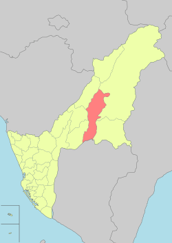 Liouguei District in Kaohsiung City | |
| Country | Taiwan |
| Region | Southern Taiwan |
| Population (January 2016) | |
| • Total | 13,435 |
| Website | liouguei.kcg.gov.tw (in Chinese), liouguei-en |
The residents of this district are mainly Hakka (about 44% [12]) and Hoklo Taiwanese, as well as indigenous peoples and immigrants from other China provinces. The entire region has been included in the Maolin National Scenic Area. In recent years, the tourism industry has flourished.
History
Due to the invasion of Han in the 17th century, Siraya that originally lived in the plains of Tainan was forced to migrate to Yuchin Basin, which in turn drove Taivoan from Vogavon to Pangliao, Kaohsiung in 1781, reaching nowadays Liouguei in 1799, founding community Lakkuli (Chinese: 六龜里社; Pe̍h-ōe-jī: La̍k-ku-lí-siā), also spelled Lakuri[13][14] or La-ko-li.[15]
In 1902, during early Japanese rule, the area was administered as "Lakkuli Village" (六龜里庄). In 1910, it was reorganized as Rokkiri Subprefecture (Japanese: 六龜里支廳), Akō Prefecture (阿緱廳). In 1920, it became Rokuki Village (六龜庄), under Heitō District (屏東郡), Takao Prefecture. In 1932, Rokuki was annexed into Kizan District (旗山郡) under Takao Prefecture.
After the handover of Taiwan from Japan to the Republic of China in 1945, Liouguei was incorporated into Kaohsiung County as a rural township. On 25 December 2010, the township became a district of Kaohsiung City.
In August 2019, some residents living in high-risk areas of Liouguei District were evacuated from their homes after heavy rain and flash flooding.[8]
Geology
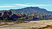
The district resembles the shape of long gourd with a vertical length of 36 km and a horizontal width of 5 km. The Laonong River passes from north to south through the center of the township.[16]
Administrative divisions
The district consists of Sinwei[9]/Xinwei, Xinxing, Xinliao, Xinfa, Peinong, Liugui, Yibao, Xinglong, Zhongxing, Baolai, Wenwu and Dajin Villages.[17]
Economy
During Japanese rule, the district was known for the production of Camphor oil. The Japanese government constructed a route and tunnels to facilitate the transportation of the product.[18]
Tourist attractions
- Baolai Spring Park
- Liouguei Tunnels
- Maolin National Scenic Area
- 18 Arhats Mountain
- Sinwei Forest Ecological Park
Agricultural Products
- "Black Diamond" Wax Jambu (Syzygium samarangense)
- Jinhuang Mango
- Jinxuan Oolong Tea
- Jujube
Transportation
See also
References
| Wikimedia Commons has media related to Liouguei District, Kaohsiung. |
| Look up Liouguei in Wiktionary, the free dictionary. |
- 臺灣地區鄉鎮市區級以上行政區域名稱中英對照表 (PDF). Online Translation System of Geographic Name, Ministry of Interior. 16 June 2011. pp. 4–5. Archived from the original (PDF) on 25 March 2012.
高雄市 Kaohsiung City{...}六龜區 Liugui District
- "Administrative Districts". 高雄市政府. 30 September 2016. Retrieved 4 April 2017.
Liouguei District:
- "About us". Liouguei District Office, Kaohsiung City. Retrieved 30 July 2019.
Liouguei district is located on the northernmost end of Pingdi Township in the remote mountain region of Kaohsiung City; it is penetrated by the Danshuei River at the bottom and the west bank of the Laonong River at the top.
- Liouguei (Variant - V) at GEOnet Names Server, United States National Geospatial-Intelligence Agency
- 王柔婷, 陳顯坤 (5 June 2017). "KAOHSIUNG'S TAUYUAN HAS ACCUMULATED RAINFALL OF 1,337 MM IN 3 DAYS, MOST IN TAIWAN 桃源累積雨量冠全台 勤和部落10民宅沖毀". Public Television Service. Retrieved 30 July 2019.
Other areas affected in Kaohsiung include an indigenous tribe near the Laonong Creek, and some Liouguei District residents took precautionary evacuation, no injury was reported.
CS1 maint: uses authors parameter (link) - Su Mu-chun, Wu Che-hao, Yeh Tze-kung, Chen Chi-fong, Emerson Lim and Chung Yu-chen (16 August 2019). "Over 3,000 people evacuated in Kaohsiung due to torrential rain". Focus Taiwan. Retrieved 22 October 2019.
Over the past 24 hours, mountainous areas of Kaohsiung, including the city's Taoyuan and Namasia Districts, have received over 400 millimeters of rain, while the accumulated rainfall in Liouguei, Maolin and Jiasian Districts exceeded 300mm.{...}mudslide caused by heavy rain in Liouguei District{...}Troops also assisted local government units in Jiasian, Liouguei and Shanlin districts in Kaohsiung City in evacuating residents from high-risk areas as a preemptive measure to ensure their safety.
CS1 maint: uses authors parameter (link) - Vu To-Anh Phan and Darn-Horng Hsiao (April 2018). "Undrained behavior and shear strength of clean sand containing low-plastic fines". IOP Conference Series: Earth and Environmental Science. Bibcode:2018EGUGA..20.3194L.
2. Materials tested sample preparation Soil specimens were taken from Liouguei District, located in Kaohsiung city, Taiwan. A quantity of natural sandy soil was carefully sieved
CS1 maint: uses authors parameter (link) - "CWB issues heavy rain warnings for southern Taiwan". Taipei Times. 17 August 2019. Retrieved 23 October 2019.
Troops also assisted local government units in Liouguei (六龜), Jiasian (甲仙) and Shanlin (杉林) districts in Kaohsiung to evacuate residents from high-risk areas as a pre-emptive measure to ensure their safety, Wu said.
- Chen Ting-fang (October 2019). "Black Rice Festival, Butterfly Watching in Maolin District". Love Kaohsiung 愛·高雄. No. 4. Translated by Hou Ya-ting. Information Bureau, Kaohsiung City Government. p. 2.
Maolin Scenic Area Administration No. 171, Sinwei Village, Liouguei District
- "History". Liouguei District Office, Kaohsiung City. Retrieved 29 July 2019.
Tribal name theory Liouguei was called Liouguei Li because of the group name of the Sih She Shou Fan Mang Zih Mang Fan of the Pinbu Tribe “Lakuri”, during the Japanese occupation in 1920 it was renamed Liouguei Li Village.{...}Address:No.18, Minjhih Rd., Liouguei District, Kaohsiung City 844, Taiwan (R.O.C.)
- "認識六龜 - 基本資料 (Introduction to Liugui)". Liouguei District Office, Kaohsiung City. 2013-10-24. Archived from the original on 2018-06-12. Retrieved 2018-06-10.
- "各鄉鎮客家人口統計 (PDF) -- Hakka Demographic Statistics by Township (Chinese)" (PDF). Archived from the original (PDF) on 2017-10-10. Retrieved 2019-01-03.
- "Entry #40046 (六龜里社)". 臺灣閩南語常用詞辭典 [Dictionary of Frequently-Used Taiwan Minnan]. (in Chinese and Hokkien). Ministry of Education, R.O.C. 2011.
- 運正, 張. "六龜鄉文化與特色 (Cultures in Liugui District)" (PDF). Retrieved 2018-06-10.
- 游, 永福 (2019). 尋找湯姆生:1871臺灣文化遺產大發現 (John Thompson x Formosa). New Taipei: Walkers. p. 13. ISBN 9789865080433.
- "Liouguei District". Liouguei District Office, Kaohsiung City. Retrieved 19 February 2018.
- https://www.cec.gov.tw/pc/en/TV/nm64000003200000000.html
- "Liouguei Tunnels prove popular visitor attraction". Taipei Times. 16 February 2018. Retrieved 19 February 2018.