Linnei
Linnei Township (Chinese: 林內鄉; pinyin: Línnèi Xiāng) is a rural township in Yunlin County, Taiwan. It is the second smallest township in Yunlin County after Baozhong Township.
Linnei Township 林內鄉 | |
|---|---|
Rural township | |
_of_Taiwan_Railway_Zhuoshui_River_Bridge_%E5%8F%B0%E9%90%B5%E4%B8%80%E4%BB%A3%E6%BF%81%E6%B0%B4%E6%BA%AA%E6%A9%8B%E6%A9%8B%E5%A2%A9%E9%81%BA%E8%B7%A1(%E5%8D%97%E5%B2%B8)%E8%88%87%E4%B8%89%E4%BB%A3%E6%BF%81%E6%B0%B4%E6%BA%AA%E6%A9%8B.jpg) Rail bridge crossing the Zhuoshui River in Linnei Township | |
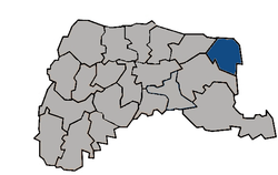 Linnei Township in Yunlin County | |
| Location | Yunlin County, Taiwan |
| Area | |
| • Total | 38 km2 (15 sq mi) |
| Population (July 2018) | |
| • Total | 18,242 |
| • Density | 480/km2 (1,200/sq mi) |
History
During the Japanese era, Toroku Town (斗六街) covered modern-day Douliu and Linnei and was under Toroku District of Tainan Prefecture.
Geography
It has a population total of 18,970 and an area of 37.6035 km2.
Administrative divisions
Linnan, Linzhong, Linbei, Pingding, Linmao, Jiuqiong, Huben, Wutu, Wuma and Zhongxing Village.
Tourist attractions
- Baima Temple
- Farming and Irrigation Artifacts Museum
- Linnei Park
- Mount Xiao Huang
- Pingding Ruins
- Tian Shen Temple
- Wutu Power Plant
Transportation
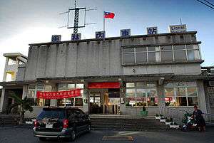
Linnei Station
The township is accessible by Linnei Station of the Taiwan Railway Administration.
gollark: No.
gollark: I tripped on one of the power cables and accidentally sent a few of them into ideatic apiospace.
gollark: Probably.
gollark: I think some of them protrude slightly into the fourth dimension.
gollark: We have them in a bunch of sizes for annoying budget reasons.
References
This article is issued from Wikipedia. The text is licensed under Creative Commons - Attribution - Sharealike. Additional terms may apply for the media files.