Lichtenau, Westphalia
Lichtenau is a municipality in the district of Paderborn, in North Rhine-Westphalia, Germany.
Lichtenau | |
|---|---|
_Rathaus.jpg) Town hall in Lichtenau | |
 Coat of arms | |
Location of Lichtenau within Paderborn district 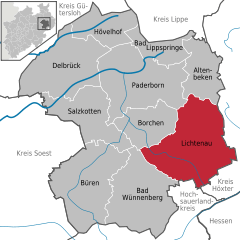  | |
 Lichtenau  Lichtenau | |
| Coordinates: 51°36′00″N 08°53′00″E | |
| Country | Germany |
| State | North Rhine-Westphalia |
| Admin. region | Detmold |
| District | Paderborn |
| Subdivisions | 15 |
| Government | |
| • Mayor | Josef Hartmann (Die PARTEI) |
| Area | |
| • Total | 192.17 km2 (74.20 sq mi) |
| Highest elevation | 407 m (1,335 ft) |
| Lowest elevation | 179 m (587 ft) |
| Population (2018-12-31)[1] | |
| • Total | 10,632 |
| • Density | 55/km2 (140/sq mi) |
| Time zone | CET/CEST (UTC+1/+2) |
| Postal codes | 33162–33165 |
| Dialling codes | 05295 05292 Atteln 05647 Kleinenberg 05259 Herbram-Wald 02994 Blankenrode |
| Vehicle registration | PB |
| Website | www.lichtenau.de |
Geography
Lichtenau is situated on the western slope of the Eggegebirge, approx. 15 km south-east of Paderborn.
Division of the town
After the local government reforms of 1975 Lichtenau consists of the following 15 districts:
- Lichtenau District
- Asseln
- Atteln
- Blankenrode
- Dalheim
- Ebbinghausen
- Grundsteinheim
- Hakenberg
- Henglarn
- Herbram
- Holtheim
- Husen
- Iggenhausen
- Kleinenberg
Twin Towns
gollark: Hmm, more controversial politics:- human rights good- encryption good, trying to make stuff not end0to-end encrypted bad- government intervention in everyday life should be lower- school is bad and needs a rework
gollark: You?
gollark: <@623743560650588202> POLITICSNUCLEAR GOODSOLAR POWER PROBLEMATIC, COAL ALSO BADAUTHORITARIAN GOVERNMENTS BAD
gollark: ++choose 1000 politics
gollark: <@623743560650588202> Politics politics? Politics, politics politics politics, politics politics.
References
- "Bevölkerung der Gemeinden Nordrhein-Westfalens am 31. Dezember 2018" (in German). Landesbetrieb Information und Technik NRW. Retrieved 10 July 2019.
External links
- Official site (in German)
- Town history (in German)
| Wikimedia Commons has media related to Lichtenau (Westfalen). |
Towns and municipalities in Paderborn (district) | ||
|---|---|---|
Coat of Arms of Paderborn district | ||
This article is issued from Wikipedia. The text is licensed under Creative Commons - Attribution - Sharealike. Additional terms may apply for the media files.