Lauteraarhorn
The Lauteraarhorn is a peak (4,042 m) of the Aarmassif in the Bernese Alps in Switzerland. It lies close to the Schreckhorn (to the north) and the Finsteraarhorn (to the south). At the foot of the Lauteraarhorn lie the Lauteraar and the Finsteraar Glaciers, tributaries of the Unteraar Glacier.
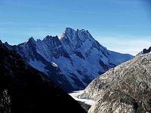
The Lauteraarhorn above the Unteraar Glacier
| Lauteraarhorn | |
|---|---|
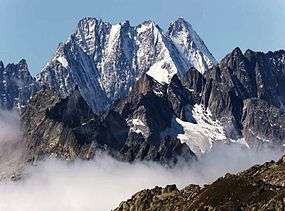 The Lauteraarhorn seen from the Grimselsee | |
| Highest point | |
| Elevation | 4,042 m (13,261 ft) |
| Prominence | 128 m (420 ft) [1] |
| Parent peak | Schreckhorn |
| Isolation | 1.0 km (0.62 mi) [2] |
| Coordinates | 46°35′00.2″N 8°07′42.3″E |
| Geography | |
 Lauteraarhorn Location in Switzerland | |
| Location | Canton of Bern, Switzerland |
| Parent range | Bernese Alps |
| Climbing | |
| First ascent | 8 August 1842 by Pierre Jean Édouard Desor, Christian Girard, Arnold Escher von der Linth with guides Melchior Bannholzer and Jakob Leuthold |
| Easiest route | rock/snow climb |
The first ascent was on 8 August 1842 by Pierre Jean Édouard Desor, Christian Girard, Arnold Escher von der Linth with the guides Melchior Bannholzer and Jakob Leuthold.
See also
- List of 4000 metre peaks of the Alps
References
- Retrieved from the Swisstopo topographic maps. The key col is the Schrecksattel (3,914 m).
- Retrieved from Google Earth. The nearest point of higher elevation is southeast of the Schreckhorn.
- Dumler, Helmut and Willi P. Burkhardt, The High Mountains of the Alps, London: Diadem, 1994
This article is issued from Wikipedia. The text is licensed under Creative Commons - Attribution - Sharealike. Additional terms may apply for the media files.