Lampertswalde
Lampertswalde is a municipality in the district of Meißen, in Saxony, Germany.
Lampertswalde | |
|---|---|
 Coat of arms | |
Location of Lampertswalde within Meißen district 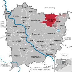 | |
 Lampertswalde  Lampertswalde | |
| Coordinates: 51°19′N 13°40′E | |
| Country | Germany |
| State | Saxony |
| District | Meißen |
| Municipal assoc. | Schönfeld |
| Government | |
| • Mayor | Wolfgang Hoffmann |
| Area | |
| • Total | 63.52 km2 (24.53 sq mi) |
| Elevation | 152 m (499 ft) |
| Population (2018-12-31)[1] | |
| • Total | 2,582 |
| • Density | 41/km2 (110/sq mi) |
| Time zone | CET/CEST (UTC+1/+2) |
| Postal codes | 01561 |
| Dialling codes | 035248 |
| Vehicle registration | MEI, GRH, RG, RIE |
| Website | www.gemeinde-lampertswalde.de |
Municipality subdivisions
Lampertswalde includes the following subdivisions:
- Adelsdorf (formerly Dorf der Jugend)
- Blochwitz
- Brockwitz
- Brößnitz
- Mühlbach
- Oelsnitz
- Niegeroda
- Quersa
- Schönborn
- Weißig am Raschütz
gollark: Exciting news: I have chosen the next task. I am waiting on ubqposting™, which I'm sure will happen at some point.
gollark: I'm thinking:- simple number theory or other mathy problem- matrix algorithm of some kind- emulate a basic CPU
gollark: I plan to do so within 1.5 days.
gollark: Epicbot got 13/12 somehow.
gollark: Lyricly got two guesses right so he doesn't have to leave.
References
- "Bevölkerung des Freistaates Sachsen jeweils am Monatsende ausgewählter Berichtsmonate nach Gemeinden" (PDF). Statistisches Landesamt des Freistaates Sachsen (in German). July 2019.
Towns and municipalities in Meissen (district) | ||
|---|---|---|
Coat of arms | ||
This article is issued from Wikipedia. The text is licensed under Creative Commons - Attribution - Sharealike. Additional terms may apply for the media files.