Laguna Caldera
Laguna Caldera is a geographical depression in Rizal, Philippines. It is broadly elliptical in shape, with dimensions of 20 by 10 km. It has a summit elevation of 743 m or 2,438 feet.[1] The caldera forms the middle lobe of Laguna de Bay, bound by the Morong Peninsula and Talim Island to the west, and the Jalajala Peninsula to the east.According To Philippine Institute of Volcanology and Seismology this caldera is a potentially active volcano
| Laguna Caldera | |
|---|---|
.svg.png) Laguna Caldera Location of Laguna Caldera in the Philippines | |
| Highest point | |
| Elevation | 743 m (2,438 ft) |
| Coordinates | 14°27′30″N 121°20′46″E |
| Geography | |
| Location | Rizal, Philippines |
| Geology | |
| Volcanic arc/belt | Macolod Corridor |
Caldera activity started 1 million years ago, with the youngest eruption dated to 27,000-29,000 years ago. Deposits from the caldera form thick ignimbrite sheets in Rizal, Metro Manila, Laguna, and Bulacan.[2] Remnants of volcanic activity include undated maars at the southern end of Talim Island and a solfatara field on nearby Mount Sembrano.[1]
Photographs
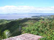
 Laguna Caldera looking east
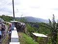 Laguna Caldera looking south-east
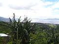 Laguna Caldera looking south
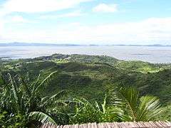 Laguna Caldera looking west
- Laguna Caldera looking northwest
See also
References
- "Global Volcanism Program | Laguna Caldera". volcano.si.edu. Retrieved 2019-08-27.
- Catane, S. G. (2005). Explosive volcanism in the Philippines. Sendai-shi: Tōhoku Daigaku Tōhoku Ajia Kenkyū Sentā. ISBN 4901449257. OCLC 61505021.
"The Largest Lake in the Philippines" | |||||||
| Location | 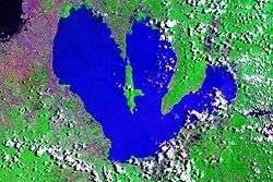 | ||||||
| Basin country | |||||||
| Islands | |||||||
| Primary outflow | |||||||
| Primary inflows |
| ||||||
| Settlements |
| ||||||