Ladná
Ladná, until 1950 Lanštorf (German: Rampersdorf) is a village and municipality (obec) in Břeclav District in the South Moravian Region of the Czech Republic.
Ladná | |
|---|---|
Municipality | |
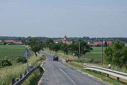 Village seen from the northeast | |
 Flag  Coat of arms | |
 Ladná | |
| Coordinates: 48°48′19″N 16°52′20″E | |
| Country | |
| Region | South Moravian |
| District | Břeclav |
| Area | |
| • Total | 10.06 km2 (3.88 sq mi) |
| Population (1.1.2012) | |
| • Total | 1,239 |
| • Density | 120/km2 (320/sq mi) |
| Postal code | 691 46 |
| Website | http://www.obecladna.cz/ |
The municipality covers an area of 10.06 square kilometres (3.88 sq mi), and has a population of 1,197.
Ladná lies approximately 6 kilometres (4 mi) north of Břeclav, 48 km (30 mi) south-east of Brno, and 228 km (142 mi) south-east of Prague.
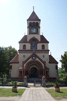
Church of St Michael Archangel in Ladná
References
This article is issued from Wikipedia. The text is licensed under Creative Commons - Attribution - Sharealike. Additional terms may apply for the media files.