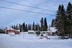
Lac-Saguay, Quebec
Lac-Saguay is a village municipality in Antoine-Labelle Regional County Municipality in the Laurentides region of Quebec, Canada.
Lac-Saguay | |
|---|---|
Village municipality | |
 | |
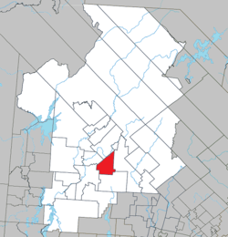 Location within Antoine-Labelle RCM | |
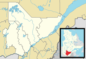 Lac-Saguay Location in central Quebec | |
| Coordinates: 46°30′N 75°09′W[1] | |
| Country | |
| Province | |
| Region | Laurentides |
| RCM | Antoine-Labelle |
| Constituted | July 1, 1951 |
| Government | |
| • Mayor | Francine Asselin Bélisle |
| • Federal riding | Laurentides—Labelle |
| • Prov. riding | Labelle |
| Area | |
| • Total | 184.90 km2 (71.39 sq mi) |
| • Land | 172.66 km2 (66.66 sq mi) |
| Population (2011)[3] | |
| • Total | 446 |
| • Density | 2.6/km2 (7/sq mi) |
| • Pop 2006-2011 | |
| • Dwellings | 445 |
| Time zone | UTC−5 (EST) |
| • Summer (DST) | UTC−4 (EDT) |
| Postal code(s) | J0W 1L0 |
| Area code(s) | 819 |
| Highways | |
| Census profile | 2479060[3] |
| MAMROT info | 79060[2] |
| Toponymie info | 144510[1] |
| Website | www |
Demographics
Population trend:[4]
- Population in 2011: 446
- Population in 2006: 492
- Population in 2001: 382 (or 392 when adjusted to 2006 boundaries)
- Population in 1996: 318 (or 378 when adjusted to 2001 boundaries)
- Population in 1991: 305
Private dwellings occupied by usual residents: 216 (total dwellings: 445)
Mother tongue:
- English as first language: 2%
- French as first language: 98%
- English and French as first language: 0%
- Other as first language: 0%
gollark: I ensure that I'm not tied to any particular company by using commodity hardware and randomly changing OS and such unnecessarily.
gollark: Greetings, mortal.
gollark: ARM laptops have been a thing for a while. They just weren't very popular, or good.
gollark: If nothing else, they have excellent CPU designers.
gollark: And it *is* ubiquitous in high-power platforms; Intel just messed up entry into mobile. I don't know exactly why. Possibly the lack of ability to include x86 cores in custom designs.
References
- Reference number 144510 of the Commission de toponymie du Québec (in French)
- Geographic code 79060 in the official Répertoire des municipalités (in French)
- "(Code 2479060) Census Profile". 2011 census. Statistics Canada. 2012.
- Statistics Canada: 1996, 2001, 2006, 2011 census
Adjacent Municipal Subdivisions | ||||||||||
|---|---|---|---|---|---|---|---|---|---|---|
| ||||||||||
| Cities/towns | |
|---|---|
| Municipalities |
|
| Villages | |
| Unorganized territories | |
| |
This article is issued from Wikipedia. The text is licensed under Creative Commons - Attribution - Sharealike. Additional terms may apply for the media files.