La Honda Creek
La Honda Creek is a small river in San Mateo County, California and is a tributary of San Gregorio Creek.[1] It flows about 7 miles (11 km), from its source (37°23′32″N 122°17′30″W) near Bear Gulch Road and Skyline Boulevard (CA 35), to its confluence with Alpine Creek to form San Gregorio Creek in La Honda.
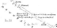
Portion of Rancho Cañada de Raymundo map showing La Honda Creek headwaters in 1856
| La Honda Creek | |
|---|---|
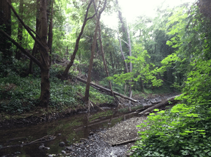 La Honda Creek flows through Play Bowl in La Honda, California. | |
| Location | |
| Country | United States |
| Physical characteristics | |
| Source | |
| • location | California |
| Mouth | |
• location | San Gregorio Creek |
• elevation | 320 feet (100 m) |
| Length | about 7 miles (11 km) |

The creek in November 2015, at the end of California's dry season.

The creek in January 2016, during the wet season.
The creek was listed as Arroyo Ondo on several diseños on the Mexican land grants and as Arroyo Hondo on the 1856 Rancho Cañada de Raymundo map. Hondo is Spanish for 'deep'.[2]
California State Route 84 (CA 84) follows the valley of the creek from Sky Londa to San Gregorio. A large part of the creek's upper watershed is in La Honda Creek Open Space Preserve.
References
- "La Honda Creek". Geographic Names Information System. United States Geological Survey. January 19, 1981. Retrieved November 9, 2009.
- Gudde, Erwin G. (1998). California place names : the origin and etymology of current geographical names (4th ed., rev. and enl. ed.). Berkeley: University of California Press. p. 169. ISBN 0520213165.
See also
| Peaks |  | |
|---|---|---|
| Rivers and creeks |
| |
| Parks | ||
| Hiking trails | ||
| Open Space Preserves |
| |
| Other | ||
This article is issued from Wikipedia. The text is licensed under Creative Commons - Attribution - Sharealike. Additional terms may apply for the media files.