Deer Creek (Santa Clara County, California)
Deer Creek is a small stream, a right tributary of Matadero Creek, originating in the foothills of the Santa Cruz Mountains in Santa Clara County, California, United States. From its source in Los Altos Hills, the creek flows in a northerly direction for 2.5 miles (4 km)to join Matadero Creek in Palo Alto.
| Deer Creek Purisima Creek on some maps[1] | |
|---|---|
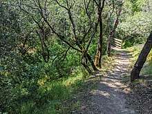
 Deer Creek at La Barranca Road, Los Altos Hills | |
| Location | |
| Country | United States |
| State | California |
| Region | Santa Clara County |
| Physical characteristics | |
| Source | Foothills of the Santa Cruz Mountains |
| • location | Los Altos Hills, California |
| • coordinates | 37°21′46″N 122°08′59″W[1] |
| • elevation | 128 ft (39 m) |
| Mouth | Matadero Creek |
• location | Palo Alto, California |
• coordinates | 37°24′16″N 122°09′08″W[1] |
• elevation | 0 ft (0 m)[1] |
Deer Creek begins at elevation 680 feet just north of Altamount Road and west of Taafe Road in Los Altos Hills, then flows northerly passing under Interstate 280 at the La Barranca Road underpass, where it turns west and parallels Purissima Road, crosses Arastradero Road and Deer Creek Road, before joining the Matadero Creek mainstem just south of Foothill Expressway and east of Page Mill Road.[2] Deer Creek has also been labelled as Purisima Creek on some maps.[3]


References
- U.S. Geological Survey Geographic Names Information System: Deer Creek
- Douglas Graham. "The Creeks of Barron Park – Part One in the Barron Park Association Newsletter" (PDF). Barron Park Association Newsletter. Retrieved 2011-11-13.
- U.S. Geological Survey Geographic Names Information System: Deer Creek – The 1961–1969 USGS topo maps label Deer Creek as Purisima Creek, but the 1976 map corrects this; the next creek to the southeast is Purisima Creek, a tributary of Adobe Creek.

