Léraba Province
Léraba is one of the 45 provinces of Burkina Faso, located in its Cascades Region.
Léraba | |
|---|---|
Province | |
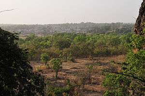
 View of the town of Sindou, capital of Léraba Province | |
 Location in Burkina Faso | |
 Provincial map of its departments | |
| Country | |
| Region | Cascades Region |
| Capital | Sindou |
| Area | |
| • Total | 3,129 km2 (1,208 sq mi) |
| Population (2006) | |
| • Total | 124,422 |
| • Density | 40/km2 (100/sq mi) |
| Time zone | UTC+0 (GMT 0) |
Its capital is Sindou. Its highest point (and the highest point of the country) is Mount Tenakourou with an elevation of 747 metres (2,451 ft).
Departments
Leraba is divided into 8 departments:
| Department | Capital city | Population (Census 2006)[1] |
|---|---|---|
| Dakoro Department | Dakoro | 13,204 |
| Douna Department | Douna | 9,025 |
| Kankalaba Department | Kankalaba | 9,675 |
| Loumana Department | Loumana | 23,955 |
| Niankorodougou Department | Niankorodougou | 34,196 |
| Oueleni Department | Oueleni | 12,130 |
| Sindou Department | Sindou | 18,484 |
| Wolonkoto Department | Wolonkoto | 3,753 |
gollark: Even fizzbuzz, say.
gollark: Yep. Or just most things.
gollark: You could say that about MOST programmers.
gollark: You, maybe, but assembly is still really quite hard because it does not abstract much.
gollark: Anyway, point is, assembly is absolutely not easier to do nontrivial things in than high-level languages, because high-level languages provide many helpful shortcuts.
References
- "National 2006 census preliminary results" (PDF). Archived from the original (PDF) on 2015-07-21. Retrieved 2014-10-25.
This article is issued from Wikipedia. The text is licensed under Creative Commons - Attribution - Sharealike. Additional terms may apply for the media files.