Kotrag Nunatak
Kotrag Nunatak (Nunatak Kotrag \'nu-na-tak ko-'trag\) is a conspicuous rocky peak of elevation 290 m projecting from Murgash Glacier, Greenwich Island in the South Shetland Islands, Antarctica. It was named after Khan Kotrag, founder of the Kingdom of Volga Bulgaria in the 7th Century AD.
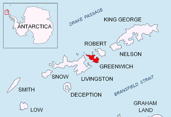
Location of Greenwich Island in the South Shetland Islands.
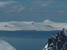
Kotrag Nunatak from Kuzman Knoll, Livingston Island.

Topographic map of Livingston Island, Greenwich, Robert, Snow and Smith Islands.
Location
The peak is located at 62°29′37.3″S 59°53′50″W which is 540 m southwest of Lloyd Hill, 1.47 km east of Telerig Nunatak, and 970 m west of Altsek Nunatak (Bulgarian topographic survey Tangra 2004/05 and mapping in 2009).
Maps
- L.L. Ivanov et al. Antarctica: Livingston Island and Greenwich Island, South Shetland Islands. Scale 1:100000 topographic map. Sofia: Antarctic Place-names Commission of Bulgaria, 2005.
- L.L. Ivanov. Antarctica: Livingston Island and Greenwich, Robert, Snow and Smith Islands. Scale 1:120000 topographic map. Troyan: Manfred Wörner Foundation, 2009.
gollark: https://www.roguetemple.com/z/hyper/
gollark: > consoles
gollark: You simply type a command into the box and click "submit". Naturally you can't see the results, for security reasons and definitely not because that's just very hard.
gollark: My Minetest server management webUI is now able to run commands.
gollark: ++delete the communist revolution
References
- Kotrag Nunatak. SCAR Composite Antarctic Gazetteer
- Bulgarian Antarctic Gazetteer. Antarctic Place-names Commission. (details in Bulgarian, basic data in English)
External links
- Kotrag Nunatak. Copernix satellite image
This article includes information from the Antarctic Place-names Commission of Bulgaria which is used with permission.
This article is issued from Wikipedia. The text is licensed under Creative Commons - Attribution - Sharealike. Additional terms may apply for the media files.