Kotabaru Regency
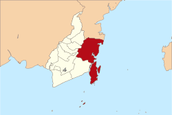
Kotabaru Regency is one of the nine regencies in the Indonesian province of South Kalimantan. It has an area of 9,482.73 km2, and a population at the 2010 Census of 290,142[1] and 319,772 at the 2015 Census; the latest official estimate (for mid 2017) is 331,326.[2] The administrative capital is Kotabaru town at the northern tip of Laut Island, the largest island off the coast of Kalimantan. Currently, a bridge to connect Laut Island to Batulicin, mainland Kalimantan is under contrusction.[3][4]
Kotabaru Regency (Kabupaten Kotabaru) | |
|---|---|
 Seal | |
| Motto(s): "Sa-ijaan" | |
 | |
| Country | Indonesia |
| Province | South Kalimantan |
| Capital | Kotabaru |
| Area | |
| • Total | 9,482.73 km2 (3,661.30 sq mi) |
| Population (2017) | |
| • Total | 290,142 319,772 331,326 |
| Time zone | UTC+8 (WITA) |
| Area code(s) | +62 518 |
| Website | kotabarukab.go.id |
Administrative districts
Kotabaru Regency is divided into twenty districts (kecamatan), listed below with their populations at the 2010 Census:[5]
|
|
gollark: Ncurses! Foiled again!
gollark: You.
gollark: oh no
gollark: Engaging orbital infolaser strike.
gollark: It would be funny if you somehow made a laser pointer which people wouldn't recognize as a laser pointer and people got worried by its ability to produce a dangerous and suspiciously narrow beam of light.
References
- Biro Pusat Statistik, Jakarta, 2011.
- Badan Pusat Statistik, Jakarta, 2018.
- Agency, ANTARA News. "Kelanjutan jembatan Kotabaru-Tanah Bumbu menunggu anggaran pemerintah". ANTARA News Kalimantan Selatan. Retrieved 2020-08-06.
- "Pemprov Kalsel, Tanbu dan Kotabaru Sepakat Alokasikan Dana Pembangunan Jembatan Kotabaru-Batulicin". Banjarmasin Post (in Indonesian). Retrieved 2020-08-06.
- Biro Pusat Statistik, Jakarta, 2011.
External links
This article is issued from Wikipedia. The text is licensed under Creative Commons - Attribution - Sharealike. Additional terms may apply for the media files.