Kingsbury Plantation, Maine
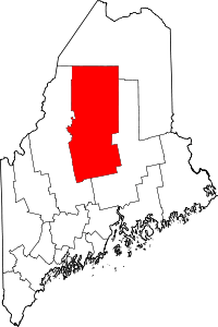
Kingsbury Plantation is a plantation in Piscataquis County, Maine, United States. The plantation was named for Judge Sanford Kingsbury, a landowner.[1] As of the 2010 census, the plantation had a total population of 28.
Kingsbury Plantation, Maine | |
|---|---|
.jpg) Kingsbury Pond | |
 Location in Piscataquis County and the state of Maine. | |
| Coordinates: 45°9′0″N 69°35′51″W | |
| Country | United States |
| State | Maine |
| County | Piscataquis |
| Area | |
| • Total | 44.6 sq mi (115.6 km2) |
| • Land | 44.1 sq mi (114.3 km2) |
| • Water | 0.5 sq mi (1.2 km2) |
| Elevation | 886 ft (270 m) |
| Population (2010) | |
| • Total | 28 |
| • Density | 0.5/sq mi (0.2/km2) |
| Time zone | UTC-5 (Eastern (EST)) |
| • Summer (DST) | UTC-4 (EDT) |
| Area code(s) | 207 |
| FIPS code | 23-37095 |
| GNIS feature ID | 0582543 |
History
The area that now contains the plantation was originally part of the Bingham Purchase and was purchased by Judge Sanford Kingsbury in 1833 for $4,000.[2] Judge Kingsbury built two mills on Kingsbury Pond in 1835,[3] and the area grew quickly enough that on March 22, 1836 it was incorporated as the town of Kingsbury.[4] By the 1880s, the town had a store, hotel, church, and two schoolhouses.[3] In 1886, the town disbanded, and it reorganized as a plantation in 1887.[4] The reorganization as a plantation was validated by the state legislature in 1895.[4]
Geography
According to the United States Census Bureau, the plantation has a total area of 44.6 square miles (116 km2), of which, 44.1 square miles (114 km2) of it is land and 0.5 square miles (1.3 km2) of it (1.08%) is water. The plantation includes Foss Pond in the north, part of Whetstone Pond in the northeast, and part of Kingsbury Pond in the southwest. The 1,532-ft high Foss Mountain is located in the plantation.[5]
Demographics
| Historical population | |||
|---|---|---|---|
| Census | Pop. | %± | |
| 1840 | 227 | — | |
| 1850 | 181 | −20.3% | |
| 1860 | 191 | 5.5% | |
| 1870 | 174 | −8.9% | |
| 1880 | 198 | 13.8% | |
| 1890 | 205 | 3.5% | |
| 1900 | 106 | −48.3% | |
| 1910 | 108 | 1.9% | |
| 1920 | 63 | −41.7% | |
| 1930 | 50 | −20.6% | |
| 1940 | 63 | 26.0% | |
| 1950 | 35 | −44.4% | |
| 1960 | 8 | −77.1% | |
| 1970 | 7 | −12.5% | |
| 1980 | 4 | −42.9% | |
| 1990 | 13 | 225.0% | |
| 2000 | 9 | −30.8% | |
| 2010 | 28 | 211.1% | |
| Est. 2014 | 27 | [6] | −3.6% |
| U.S. Decennial Census[7] | |||
As of the census[8] of 2000, there were 9 people, 6 households, and 1 family residing in the plantation. The population density was 0.2 people per square mile (0.1/km2). There were 139 housing units at an average density of 3.1 per square mile (1.2/km2). The racial makeup of the plantation was 8 White and 1 from two or more races.
There were 6 households, out of which 2 were married couples living together and 4 were non-families. 3 households were made up of individuals, and 3 had someone living alone who was 65 years of age or older. The average household size was 1.50 and the average family size was 2.00.
In the plantation the population was spread out, with 1 between 25 and 44, 3 from 45 to 64, and 5 ages 65 years of age or older. The median age was 70 years.
References
- "Profile for Kingsbury, Maine". ePodunk. Retrieved 2010-05-07.
- "History". Kingsbury Plantation. Retrieved June 24, 2020.
- Varney, George Jones (December 31, 1881). A Gazetteer of the State of Maine. Boston: B. B. Russell. p. 303.
- "Kingsbury". Maine: An Encyclopedia. Retrieved June 24, 2020.
- "Foss Mountain". Peakery.com. Retrieved June 24, 2020.
- "Annual Estimates of the Resident Population for Incorporated Places: April 1, 2010 to July 1, 2014". Archived from the original on May 23, 2015. Retrieved June 4, 2015.
- "Census of Population and Housing". Census.gov. Retrieved June 4, 2015.
- "U.S. Census website". United States Census Bureau. Retrieved 2008-01-31.
