Kihihi
Kihihi, also spelt Kihiihi, is a town in Southwestern Uganda. It is the second-largest metropolitan area in Kanungu District, after Kanungu, where the district headquarters are located.
Kihihi Kihiihi | |
|---|---|
 Kihihi Location in Uganda | |
| Coordinates: 00°44′46″S 29°42′01″E | |
| Country | |
| Region | Western Uganda |
| Sub-region | Kigezi sub-region |
| District | Kanungu District |
| Elevation | 3,740 ft (1,140 m) |
| Population (2014 Census) | |
| • Total | 20,349[1] |
| Time zone | UTC+3 (East Africa Time) |
| Climate | Aw |
Location
Kihihi is located approximately 113 kilometres (70 mi), by road, northwest of Kabale, the largest city in the sub-region.[2] Kihihi is located approximately 16 kilometres (10 mi), by road, northwest of Kanungu, where the district headquarters are located.[3] The coordinates of Kihiihi are:0°44'56.0"S, 29°42'01.0"E (Latitude:-0.748889; Longitude:29.700278).[4]
Overview
Kihihi is a small town in Kanungu District, approximately 30 kilometres (19 mi), by road, southeast of the International border with the Democratic Republic of the Congo at Ishasha. The straight distance is about 16 kilometres (10 mi), but due to the mountainous terrain, the roads are tortuous and winding.[5] The town accommodates a large refugee camp administered by the United Nations High Commission for Refugees (UNHCR). It also has one bank (Stanbic Bank), one ATM and several motels and lodges.[6]
Population
In 2002, the population census put the population of the town at 15,935. In 2010, the Uganda Bureau of Statistics (UBOS), estimated the population of Kihiihi at approximately 18,800. In 2011, UBOS estimated the population at 19,200 people.[7] In 2014, the national population census put the population of Kihiihi at 20,349.[1]
Points of interest
The following points of interest are found in Kihiihi, or close to its town limits:
- The offices and refugee camp of the UNHCR.
- The offices of Kihihi Town Council
- Kihihi Farmers Market
- A branch of Stanbic Bank.
- Garuga Airstrip
- Well-stocked supermarkets
- Boutiques
- Salons
- Kihiihi Town Council office
- Kinkiizi Radio Station
- Kinkizi Polytechnic
- Self-Contained Motels
- Bus Terminus Kihiihi-Kampala route
- Religious Worshiping Centres
- Sevpnary Schools
References
- UBOS, . (29 November 2014). "The Population of The Regions of the Republic of Uganda And All Cities And Towns of More Than 15,000 Inhabitants". Citypopulation.de Quoting Uganda Bureau of Statistics (UBOS). Retrieved 28 February 2015.CS1 maint: numeric names: authors list (link)
- "Road Distance Between Kabale And Kihihi With Interactive Map". Globefeed.com. Retrieved 28 February 2015.
- "Map Showing Kanungu And Kihiihi With Route Marker". Globefeed.com. Retrieved 28 February 2015.
- Google (5 July 2015). "Location of Kihiihi At Google Maps" (Map). Google Maps. Google. Retrieved 5 July 2015.
- "Map Showing Ishaka, Uganda And Kihihi With Route Marker". Globefeed.com. Retrieved 28 February 2015.
- Rabe, Rolf (18 May 2009). "Uganda by Bike 2008/2009: Trip Report - Kihihi". Bradtugandaupdate.wordpress.com. Retrieved 28 February 2015.
- UBOS, . (2012). "Estimated Population of Kihiihi In 2002, 2010 & 2011" (PDF). Uganda Bureau of Statistics (UBOS). Archived from the original (PDF) on 7 July 2014. Retrieved 28 February 2015.CS1 maint: numeric names: authors list (link)
External links
Capital: Kanungu | ||
| Counties and sub-counties | Kinkinzi County | 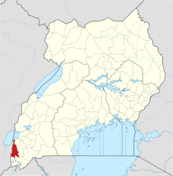 |
| Towns and villages | ||
| Energy | ||
| Economy | ||
| Notable landmarks | ||
| Transport |
| |
| Health | ||
| Education | ||
| Notable people | ||