Khitab
Khattab (Arabic: خطاب, also spelled Khutab or Khattab) is a town in northwestern Syria, administratively part of the Hama Governorate, northwest of Hama located near the Orontes River River. Nearby localities include Qamhana to the east, Shihat Hama to the southeast, Kafr al-Tun to the southwest, al-Majdal to the west, Mhardeh and Halfaya to the northwest and Taybat al-Imam to the northeast. According to the Central Bureau of Statistics, Khitab had a population of 10,830 in the 2004 census.[1] Its inhabitants are predominantly Sunni Muslims.[2]
Khitab خطاب Khutab Khattab | |
|---|---|
Town | |
.jpg) | |
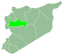
 Khitab Location in Syria | |
| Coordinates: 35°11′51″N 36°40′2″E | |
| Country | |
| Governorate | Hama |
| District | Hama |
| Subdistrict | Hama |
| Population (2004) | |
| • Total | 10,830 |
In late 1829, during the Ottoman era, Khitab was part of the Sanjak (District) of Hama. It consisted of 55 feddan and paid 5,610 qirsh in taxes to the treasury.[3] In the 1930s about two-thirds of the village's lands were owned by the al-Azm family.[4] In 1838, Khitab was recorded as a Muslim village.[5]
References
- General Census of Population and Housing 2004. Syria Central Bureau of Statistics (CBS). Hama Governorate. (in Arabic)
- "Syria rebels rampage through Sunni village, killing 1". CBS News. Associated Press. 2014-07-09.
- Douwes, 2000, pp. 224-225.
- The French Asian. 33-34. 1993: Committee of the French Asia. Page 134.
- Smith, 1841, p. 179.
Bibliography
| Wikimedia Commons has media related to Khitab. |
- Douwes, Dick (2000). The Ottomans in Syria: a history of justice and oppression. I.B. Tauris. ISBN 1860640311.
- Smith, Eli; Robinson, Edward (1841). Biblical Researches in Palestine, Mount Sinai and Arabia Petraea: A Journal of Travels in the Year 1838. 3. Crocker and Brewster.