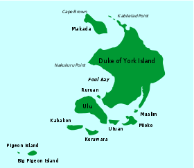
Kerawara
Kerawara is island in Duke of York Islands archipelago in Papua New Guinea.[1] It is located in the east of the country, in the East New Britain Province, about 800 km to the east of the Port Moresby.
 Duke of York Islands | |
 Kerawara | |
| Geography | |
|---|---|
| Location | Oceania |
| Coordinates | 4°15′S 152°25′E |
| Archipelago | Duke of York Islands |
| Total islands | 13 |
| Major islands | Duke of York Island, Papua New Guinea |
| Area | 0.84 km2 (0.32 sq mi) |
| Highest point | 23 |
| Administration | |
Geography
The land of Kerawara Island is flat. The highest point on the island is 23 meters above sea level. It covers 1,0 km from the north to the south and 1.7 km from the east to the west. In total island covers about 0.84 square kilometers.
gollark: Did you mean: Aaargh Why
gollark: I said *client-side*.
gollark: Anyone know of good client-side Rust web frameworks?
gollark: No, Elm's are good, Bucklescript/Fable's aren't.
gollark: In both, actually, but more so bucklescript.
References
- Kerawara Island: Papua New Guinea National Geospatial-Intelligence Agency, Bethesda, MD, USA
This article is issued from Wikipedia. The text is licensed under Creative Commons - Attribution - Sharealike. Additional terms may apply for the media files.