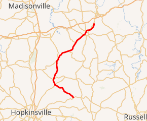
Kentucky Route 189
Kentucky Route 189 (KY 189) is a 32.027-mile-long (51.542 km) state highway in Kentucky that runs from Kentucky Route 507 and Flat Rock Road west of Allegre to U.S. Route 62 northeast of Powderly via Fearsville.
| ||||
|---|---|---|---|---|

KY 189 highlighted in red | ||||
| Route information | ||||
| Maintained by KYTC | ||||
| Length | 32.027 mi[1] (51.542 km) | |||
| Major junctions | ||||
| South end | ||||
| ||||
| North end | ||||
| Highway system | ||||
| ||||
Route description
KY 189 starts at an intersection with KY 507 in rural western Todd County between Allegre and Pilot Rock. It enters northeastern Christian County about two miles (3.2 km) from the beginning. It passes through the communities of Fearsville and Fruit Hill and has intersections with KY 107 and KY 800 in that area.
KY 189 then crosses the Pond River into Muhlenberg County. It intersects U.S. Route 62 (US 62) on the west side of Greenville and parallels US 62 from there all the way to the routes current northern terminus at another intersection with US 62 just southwest of Central City and north of Powderly.
History
At one time, KY 189 ran concurrently with US 62 from the second junction between the two routes and Central City. KY 189 had also bypassed Central City to the west and ended at a junction with US 431 in South Carrollton. That bypass was also designated as the truck route of US 431 and KY 70 on the west side of Central City. KY 189 was decommissioned from the Central City bypass when US 431 and KY 70 were rerouted to overlap US 62 and then turn onto the bypass. Since then, KY 189 has ended at the US 62 junction just south of Central City.
Major intersections
| County | Location | mi[1] | km | Destinations | Notes |
|---|---|---|---|---|---|
| Todd | | 0.000 | 0.000 | Southern terminus; continues as Flat Rock Road beyond KY 507 | |
| Christian | | 5.831 | 9.384 | Eastern terminus of KY 1682 | |
| Fearsville | 7.242 | 11.655 | South end of KY 107 overlap | ||
| 7.305 | 11.756 | North end of KY 107 overlap | |||
| | 8.879 | 14.289 | South end of KY 800 overlap | ||
| | 9.229 | 14.853 | North end of KY 800 overlap | ||
| | 14.846 | 23.892 | Northern terminus of KY 1914 | ||
| | 16.138 | 25.972 | Southern terminus of KY 813 | ||
| Muhlenberg | | 20.496 | 32.985 | Western terminus of KY 853 | |
| | 21.561 | 34.699 | Southern terminus of KY 1473 | ||
| | 23.445 | 37.731 | Southern terminus of KY 175 | ||
| | 26.815 | 43.155 | |||
| Greenville | 28.316 | 45.570 | |||
| 29.691 | 47.783 | Eastern terminus of KY 189 Conn | |||
| Powderly | 30.903 | 49.734 | Northern terminus of KY 1380 | ||
| | 32.027 | 51.542 | Northern terminus | ||
1.000 mi = 1.609 km; 1.000 km = 0.621 mi
| |||||
Greenville connector
| |
|---|---|
| Location | Greenville |
| Length | 0.135 mi[1] (0.217 km) |
Kentucky Route 189 Connector (KY 189 Conn) is a 0.135-mile-long (0.217 km) connector route of KY 189 that connects to U.S. Route 62 in northeastern Greenville.
Major intersections
The entire route is in Greenville, Muhlenberg County.
| mi[1] | km | Destinations | Notes | ||
|---|---|---|---|---|---|
| 0.000 | 0.000 | Western terminus | |||
| 0.135 | 0.217 | Eastern terminus | |||
| 1.000 mi = 1.609 km; 1.000 km = 0.621 mi | |||||
References
- "Official DMI Route Log". Kentucky Transportation Cabinet. Retrieved June 28, 2018.
