Kentucky Route 142
Kentucky Route 142 (KY 142) is a 11.200-mile-long (18.025 km) state highway in Daviess County, Kentucky. It runs from U.S. Route 231 (US 231) southeast of Masonville to KY 144 in rural Daviess County east of Owensboro
| ||||
|---|---|---|---|---|
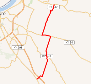
KY 142 highlighted in red | ||||
| Route information | ||||
| Maintained by KYTC | ||||
| Length | 11.200 mi[1] (18.025 km) | |||
| Major junctions | ||||
| South end | ||||
| East end | ||||
| Location | ||||
| Counties | Daviess | |||
| Highway system | ||||
| ||||

Major intersections
The entire route is in Daviess County.
| Location | mi[1] | km | Destinations | Notes | |
|---|---|---|---|---|---|
| | 0.000 | 0.000 | Southern terminus | ||
| | 3.317 | 5.338 | Northern terminus of KY 762 | ||
| Philpot | 5.980 | 9.624 | South end of KY 54 overlap | ||
| | 7.034 | 11.320 | North end of KY 54 overlap | ||
| | 11.200 | 18.025 | Northern terminus | ||
| 1.000 mi = 1.609 km; 1.000 km = 0.621 mi | |||||
gollark: (clinical tone is for BEES or PEOPLE WITH MORE CLINICAL TONE)
gollark: Item ID: SCM-F078C8EEClass: Æφ-77Description: SCM-F078C8EE is a printed photograph of an apioform. It displays no anomalous properties except that an entry about it SOMEHOW APPEARS CONSTANTLY IN THE DATABASE despite many measures taken to lock its slot.
gollark: It's ANOMALOUSLY worthy of classification.
gollark: Sthisisanorganization Cwhich Mexists.
gollark: d
References
- "Official DMI Route Log". Kentucky Transportation Cabinet. Retrieved June 27, 2015.
This article is issued from Wikipedia. The text is licensed under Creative Commons - Attribution - Sharealike. Additional terms may apply for the media files.