Kentucky Route 125
Kentucky Route 125 (KY 125) is a 6.296-mile-long (10.132 km) state highway in Fulton County. It runs from Tennessee State Route 5 (SR 5) at the Kentucky–Tennessee state line north of Woodland Mills, Tennessee, to KY 94 in Hickman.
| ||||
|---|---|---|---|---|
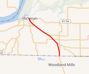
KY 125 highlighted in red | ||||
| Route information | ||||
| Maintained by KYTC | ||||
| Length | 6.296 mi[1] (10.132 km) | |||
| Major junctions | ||||
| South end | ||||
| North end | ||||
| Location | ||||
| Counties | Fulton | |||
| Highway system | ||||
| ||||

Major intersections
The entire route is in Fulton County.
| Location | mi[1] | km | Destinations | Notes | |
|---|---|---|---|---|---|
| | 0.000 | 0.000 | Southern terminus at Kentucky–Tennessee state line | ||
| | 0.482 | 0.776 | Southern terminus of KY 2140 | ||
| | 1.659 | 2.670 | Western terminus of KY 166 | ||
| | 2.282 | 3.673 | |||
| | 3.000 | 4.828 | Western terminus of KY 1129 | ||
| Hickman | 5.386 | 8.668 | |||
| 6.067 | 9.764 | Northern terminus of KY 1463 | |||
| 6.296 | 10.132 | Northern terminus; continues as Magnolia Street | |||
| 1.000 mi = 1.609 km; 1.000 km = 0.621 mi | |||||
gollark: Not really. Those particular implementations were in C. If C were replaced with another language, similar things would probably exist if there was demand.
gollark: Those could exist without C however.
gollark: I doubt it's a *likely* race condition, but I would like to avoid it.
gollark: I'm pretty sure that the solution to this in C would just be to have race conditions and not notice.
gollark: I was trying to look at how other IRCds solve this, but they're all just tens of thousands of lines of incomprehensible C which probably still contain race conditions, or miniircd, which as far as I can tell just ignores the problem.
References
- "Official DMI Route Log". Kentucky Transportation Cabinet. Retrieved January 8, 2015.
This article is issued from Wikipedia. The text is licensed under Creative Commons - Attribution - Sharealike. Additional terms may apply for the media files.