Kennett, Missouri
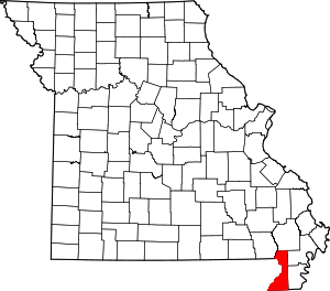
Kennett is a city in, and the county seat of, Dunklin County, Missouri, United States.[6] The city is located in the southeast corner (or "Bootheel") of Missouri, 4 miles (6.4 km) east of Arkansas and 20 miles (32 km) from the Mississippi River. It has a population of 10,932 according to the 2010 Census.[7] Kennett is the largest city in the Bootheel, a mostly agricultural area.
Kennett, Missouri | |
|---|---|
City | |
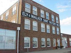
 Ely & Walker Shirt Factory 5 on Main Street | |
 Location of Kennett, Missouri | |
| Coordinates: 36°14′17″N 90°3′6″W | |
| Country | United States |
| State | Missouri |
| County | Dunklin |
| Government | |
| • Mayor | Chancellor Wayne |
| Area | |
| • Total | 7.00 sq mi (18.14 km2) |
| • Land | 7.00 sq mi (18.14 km2) |
| • Water | 0.00 sq mi (0.01 km2) |
| Elevation | 269 ft (82 m) |
| Population | |
| • Total | 10,932 |
| • Estimate (2019)[3] | 10,094 |
| • Density | 1,441.59/sq mi (556.60/km2) |
| Time zone | UTC-6 (Central (CST)) |
| • Summer (DST) | UTC-5 (CDT) |
| ZIP code | 63857 |
| Area code(s) | 573 |
| FIPS code | 29-38306[4] |
| GNIS feature ID | 0731596[5] |
| Website | cityofkennettmo.com |
History
White settlers built log cabins in the area in the first half of the 19th century, naming their settlement Chilletecaux in honor of a Delaware Indian chief who lived there. The town was renamed Butler in the late 1840s. Due to mail delivery problems because of other jurisdictions named the same, the settlement was renamed as Kennett, in honor of the mayor of the city of St. Louis, Luther M. Kennett.[8]
In the 1890s, a railroad reached the area, stimulating growth in the town. In that same period, the state began construction of a massive drainage program in the St. Francis River basin, which was floodplain and wetlands. In the 20th century, after timber clearing, the area was developed for cultivation of cotton and other commodity crops.[9]
Geography and climate
Kennett is located at 36°14′17″N 90°3′6″W (36.237974, −90.051727).[10] According to the United States Census Bureau, the city has a total area of 6.96 square miles (18.03 km2), all land.[11]
As part of the southern extremity of Missouri, Kennett has a humid subtropical climate (Köppen climate classification Cfa) with cool winters and hot, humid summers, ample precipitation through much of the year, and is part of USDA Plant Hardiness Zone 7.[12] The monthly daily average temperature ranges from 35.3 °F (1.8 °C) in January to 80.7 °F (27.1 °C) in July. On average, there are 4.9 days annually with 100 °F (38 °C)+ highs, 63 days of 90 °F (32 °C)+ highs, 9.4 days where the temperature does not rise above freezing, and 4.8 days with 10 °F (−12 °C) or lower minima.
| Climate data for Kennett, Missouri | |||||||||||||
|---|---|---|---|---|---|---|---|---|---|---|---|---|---|
| Month | Jan | Feb | Mar | Apr | May | Jun | Jul | Aug | Sep | Oct | Nov | Dec | Year |
| Average high °F (°C) | 44.9 (7.2) |
50.2 (10.1) |
60.4 (15.8) |
71.3 (21.8) |
80.1 (26.7) |
88.9 (31.6) |
91.6 (33.1) |
91.5 (33.1) |
84.5 (29.2) |
73.6 (23.1) |
59.9 (15.5) |
47.5 (8.6) |
70.4 (21.3) |
| Average low °F (°C) | 25.8 (−3.4) |
29.5 (−1.4) |
37.9 (3.3) |
47.9 (8.8) |
57.8 (14.3) |
66.5 (19.2) |
69.8 (21.0) |
67.7 (19.8) |
59.1 (15.1) |
47.1 (8.4) |
38.3 (3.5) |
28.9 (−1.7) |
48.0 (8.9) |
| Average precipitation inches (mm) | 3.67 (93) |
4.04 (103) |
4.54 (115) |
4.87 (124) |
5.49 (139) |
3.53 (90) |
3.57 (91) |
2.32 (59) |
3.32 (84) |
4.49 (114) |
4.40 (112) |
4.90 (124) |
49.14 (1,248) |
| Average snowfall inches (cm) | 3.1 (7.9) |
2.7 (6.9) |
.5 (1.3) |
0 (0) |
0 (0) |
0 (0) |
0 (0) |
0 (0) |
0 (0) |
0 (0) |
trace | .9 (2.3) |
7.2 (18) |
| Average precipitation days (≥ 0.01 in) | 7.5 | 8.3 | 9.1 | 9.2 | 9.7 | 7.4 | 7.0 | 5.4 | 6.5 | 7.4 | 8.4 | 8.6 | 94.5 |
| Average snowy days (≥ 0.1 in) | .9 | 1.5 | .1 | 0 | 0 | 0 | 0 | 0 | 0 | 0 | 0 | .6 | 3.1 |
| Source: NOAA[13] | |||||||||||||
Demographics
| Historical population | |||
|---|---|---|---|
| Census | Pop. | %± | |
| 1880 | 171 | — | |
| 1890 | 302 | 76.6% | |
| 1900 | 1,509 | 399.7% | |
| 1910 | 3,033 | 101.0% | |
| 1920 | 3,622 | 19.4% | |
| 1930 | 4,128 | 14.0% | |
| 1940 | 6,335 | 53.5% | |
| 1950 | 8,685 | 37.1% | |
| 1960 | 9,098 | 4.8% | |
| 1970 | 10,090 | 10.9% | |
| 1980 | 10,145 | 0.5% | |
| 1990 | 10,941 | 7.8% | |
| 2000 | 11,260 | 2.9% | |
| 2010 | 10,932 | −2.9% | |
| Est. 2019 | 10,094 | [3] | −7.7% |
| U.S. Decennial Census[14] | |||
The Kennett Micropolitan Statistical Area consists of Dunklin County.
As of 2000 the median household income was $26,088 and the median family income was $34,167. Males had a median income of $29,958 versus $18,770 for females. The per capita income for the city was $14,397. Living below the poverty line were 26.1% of the population and 20.5% of families. Those living below the poverty line were 37.5% of those under the age of 18 and 24.0% of those 65 and older.
2010 census
As of the census[2] of 2010, there were 10,932 people, 4,377 households, and 2,849 families residing in the city. The population density was 1,570.7 inhabitants per square mile (606.5/km2). There were 4,863 housing units at an average density of 698.7 per square mile (269.8/km2). The racial makeup of the city was 80.1% White, 16.2% African American, 0.2% Native American, 0.6% Asian, 0.1% Pacific Islander, 1.3% from other races, and 1.7% from two or more races. Hispanic or Latino of any race were 3.5% of the population.
There were 4,377 households of which 32.6% had children under the age of 18 living with them, 42.5% were married couples living together, 18.1% had a female householder with no husband present, 4.5% had a male householder with no wife present, and 34.9% were non-families. 30.2% of all households were made up of individuals and 12.4% had someone living alone who was 65 years of age or older. The average household size was 2.41 and the average family size was 2.95.
The median age in the city was 38.4 years. 25.5% of residents were under the age of 18; 8.8% were between the ages of 18 and 24; 23.7% were from 25 to 44; 25.5% were from 45 to 64; and 16.5% were 65 years of age or older. The gender makeup of the city was 47.1% male and 52.9% female.
Government
- List of Kennett mayors
Education
Kennett has six public schools operated by the Kennett School District 39. The pre-school is called Kennett Early Learning Center. The elementary schools are South Elementary School and H. Byron Masterson Elementary School. The other schools are Kennett Middle School, Kennett High School, and Kennett Career and Technical Center.[15]
Kennett Christian Academy is a co-ed, private school affiliated with the First United Pentecostal Church that opened in 1979 and offers elementary through high school classes.[16]
Kennett is home to two higher education branch institutions. Southeast Missouri State University at Kennett is a branch of the Cape Girardeau main campus and Three Rivers College (Missouri) is a branch of the Poplar Bluff main campus.
Kennett has a public library, the Dunklin County Library.[17][18]
Media
The Delta Dunklin Democrat serves as the area's local newspaper.[19]
Transportation
Kennett Memorial Airport is a city-owned, public-use airport located one nautical mile (1.85 km) southeast of the central business district of Kennett.[20]
Notable people
- Sheryl Crow, Grammy-winning singer/songwriter[21]
- John M. Dalton, former Missouri governor
- Gene Handley, professional baseball player
- Will Johnson (musician), singer/songwriter and member of band Monsters of Folk
- Paul C. Jones, former congressman from Missouri
- Dan Landrum, hammered dulcimer player who tours with Yanni
- Fred Lasswell, cartoonist of Barney Google and Snuffy Smith
- David Nail, country music recording artist
- Gib Singleton, sculptor, Fulbright Scholar
- Sally Stapleton, Pulitzer-winning photojournalist
- Jeff Stone, former left fielder for the Philadelphia Phillies
- Trent Tomlinson, country singer
- Orville Zimmerman, United States Representative for Missouri's 10th congressional district, was a member of Kennett's board of education, 1928-1936
References
- "2019 U.S. Gazetteer Files". United States Census Bureau. Retrieved July 26, 2020.
- "U.S. Census website". United States Census Bureau. Retrieved July 8, 2012.
- "Population and Housing Unit Estimates". United States Census Bureau. May 24, 2020. Retrieved May 27, 2020.
- "U.S. Census website". United States Census Bureau. Retrieved January 31, 2008.
- "US Board on Geographic Names". United States Geological Survey. October 25, 2007. Retrieved January 31, 2008.
- "Find a County". National Association of Counties. Archived from the original on May 31, 2011. Retrieved June 7, 2011.
- 2010 United States Census
- Eaton, David Wolfe (1916). How Missouri Counties, Towns and Streams Were Named. The State Historical Society of Missouri. pp. 165.
- "Archived copy". Archived from the original on February 28, 2009. Retrieved November 5, 2008.CS1 maint: archived copy as title (link)
- "US Gazetteer files: 2010, 2000, and 1990". United States Census Bureau. February 12, 2011. Retrieved April 23, 2011.
- "US Gazetteer files 2010". United States Census Bureau. Archived from the original on July 2, 2012. Retrieved July 8, 2012.
- "Station Name: MO KENNETT RADIO KBOA". National Oceanic and Atmospheric Administration. Retrieved June 24, 2013.
- "Census of Population and Housing". Census.gov. Retrieved June 4, 2015.
- "Archived copy". Archived from the original on October 27, 2008. Retrieved November 5, 2008.CS1 maint: archived copy as title (link)
- "Kennett, Missouri Chamber of Commerce - Education". Retrieved June 15, 2019.
- "Missouri Public Libraries". PublicLibraries.com. Archived from the original on June 10, 2017. Retrieved June 2, 2019.
- "Dunklin County Library". Retrieved June 15, 2019.
- "Delta Dunklin Democrat". Retrieved June 15, 2019.
- FAA Airport Master Record for TKX (Form 5010 PDF). Federal Aviation Administration. Effective February 11, 2010.
- Hogg, Karen (April 1, 2001). Guitar Styles -- Women in Rock: The Guitarist's Guide to Music of the Masters. Alfred Music Publishing. p. 16. ISBN 978-0-7390-2016-6.
External links
- Official website
- Kennett Chamber of Commerce
- Historic maps of Kennett in the Sanborn Maps of Missouri Collection at the University of Missouri
