Kaulsdorf (Berlin)
![]()
Kaulsdorf | |
|---|---|
Quarter of Berlin | |
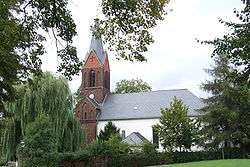 Village church | |
Location of Kaulsdorf in Marzahn-Hellersdorf and Berlin 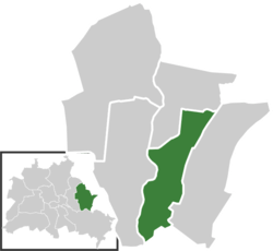 | |
 Kaulsdorf  Kaulsdorf | |
| Coordinates: 52°30′29″N 13°34′51″E | |
| Country | Germany |
| State | Berlin |
| City | Berlin |
| Borough | Marzahn-Hellersdorf |
| Founded | 1347 |
| Subdivisions | 3 zones |
| Area | |
| • Total | 8.1 km2 (3.1 sq mi) |
| Elevation | 52 m (171 ft) |
| Population (2008-06-30) | |
| • Total | 18,941 |
| • Density | 2,300/km2 (6,100/sq mi) |
| Time zone | CET/CEST (UTC+1/+2) |
| Postal codes | (nr. 1003) 12621, 12619 |
| Vehicle registration | B |
History
The village was first mentioned as Caulstorp in a 1347 deed of gift by margrave Louis I of Brandenburg to the Kaland monastic brotherhood in Bernau. During the Thirty Years' War it was completely devastated by armed conflicts and epidemics.
Geography
Subdivision
Kaulsdorf is divided into 3 zones (Ortslagen):
- Alt Kaulsdorf
- Kaulsdorf-Nord
- Kaulsdord-Süd
Buildings
The village church (aka Jesus Church) dates back to the 14th century, its Romanesque apse may be preserved from a predecessing building. The steeple was attached in 1875 and today houses a small museum.
For the Modern Catholic church St. Martin built in 1929-1930, Charles Crodel from 1942 to 1946 created 26 windows and nine round windows as well as a mosaic wall and an enamel work for the altar.
Transportation
Kaulsdorf is served by the S-Bahn train line S5 at the station Wuhletal and Kaulsdorf as well as by the U-Bahn line U5 at the stations Wuhletal and Kaulsdorf-Nord.
External links
![]()
- (in German) Biesdorf page on info-marzahn-hellersdorf.de
| |
| |