Kattikkulam, Wayanad
Kattikkulam(Kartikulam) is a small town near Mananthavady in Wayanad district, Kerala, India. It is also the headquarters of the Thirunelli gramapanchayath.
Kattikkulam (Kartikulam/കാട്ടിക്കുളം) | |
|---|---|
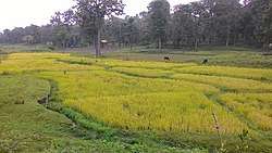
 Paddy Fields on the sides of Kattikkulam Mysore road. | |
| Coordinates: 11.84683°N 76.06313°E | |
| Country | |
| State | Kerala |
| District | Wayanad |
| Time zone | UTC+5:25 (IST) |
| PIN | 670646 |
This small town serves as the starting point for most of the tourists and pilgrims from Kerala and Karnataka who come to visit places like Thirunelli Temple, Bavali Maqam, Padamala church, Kuruvadweep, Tholpetty, Panavalli, Coorg, Mysore etc.
It is very well connected by road with Mananthavady, Mysore, Bangalore and the district of Coorg. Almost all the buses plying from Kozhikode (Calicut) and Kannur to Mysore and vice versa during night have to pass this town because the NH 766 connecting Kozhikode (Calicut) and Mysore through Sulthan Bathery closes at 9 pm.
It is being developed as a more or less satellite town of Mananthavady. Many new infrastructure facilities are being added to this town every year.
There are a few good restaurants and hotels available in this town. Many homestays, lodges and resorts are also available in and around this area.
Two petrol bunks are available in this town.
One ATM counter owned by Wayanad District Co-operative Bank also functions here near the Holiday Hill hotel.
Important Organizations
- Kattikkulam Govt. Higher Secondary School
- Thirunelly Panchayath Office
- Thirunelly Panchayath Bus Stand
- Kartikkulam RTO Checkpost
- Kartikulam Police Aid Post
- Post Office Kartikulam
- Thirunelly Panchayat Community Hall
- Primary Health Centre Kartikulam
- Kerala Gramin Bank
- Wayanad District Co-operative Bank
- Thirunelly Service Co-operative Bank
- Holiday Hill Hotel
Places to visit
Kuruvadweep is a 950 acre protected river delta on the Kabini River in the Wayanad district. It is home for a variety of species of birds and animals. It is about 6 km from Kattikulam town. Buses are available regularly.
Thirunelly Temple is an ancient temple and pilgrimage which is about 22 km from Kartikulam. Buses ply from Mananthavady on regular intervals.
Pakshi Pathalam is a trekking site some seven kilometers from Thirunelli temple. There is an ancient cave on the hillock with plenty of birds.
Tholpetty Wildlife Sanctuary is a very famous trekking spot which is located at a distance of 16 km from Kartikulam.Buses are available regularly.
Irupp Falls is located in the Kodagu district of Karnataka bordering the Wayand district of Kerala. It is located at a distance of 26 km from Kartikulam.
Transportation
Kattikkulam can be accessed from Mananthavady,Mysore and Coorg.
Road distance from nearest towns:
Mananthavady -10 km
Kalpetta-33 km
Sulthan Bathery-39 km
Thalassery -89 km
Kannur- 96 km
Kozhikode-103 km
Mysore -100 km
Madikeri-100 km
Ooty-132 km
Bangalore- 251 km
Kochi-288 km
The shortest route which connects Mananthavady with Mysore passes through Kartikulam. This road passing through Bavali usually closes after 6 pm. But the road along Kartikulam-Kutta-Gonikoppal-Mysore is open 24 hours.
The nearest railway station is at Thalassery (80 km)
Kozhikode railway station is at a distance of 106 km
Mysore railway station is at distance of 102 km
Nearest airport which is in operation is the Kannur International Airport-73 km
Other nearest airports available are:
Calicut international airport -128km
Cochin International Airport Ltd. -275 km
Bengaluru International Airport-290 km
Mysuru airport-102 km
Location
Located on the north eastern side of Wayanad district along the road connecting Mananthavady and Mysore at a distance of 9 km from Mananthavady.