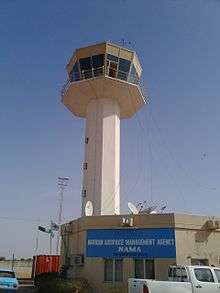
Katsina Airport
Katsina Airport (IATA: DKA, ICAO: DNKT, TC LID: DN57) is an airport serving Katsina, the capital of Katsina State in Nigeria. The runway is on the northeast side of the city.
Katsina Airport Umaru Musa Yar'adua Airport Umaru Musa Yar'adua Filin Jirgin Sama (Hausa) | |||||||||||
|---|---|---|---|---|---|---|---|---|---|---|---|
 | |||||||||||
| Summary | |||||||||||
| Airport type | Public | ||||||||||
| Owner/Operator | Federal Airports Authority of Nigeria | ||||||||||
| Serves | Katsina, Nigeria | ||||||||||
| Elevation AMSL | 1,685 ft / 514 m | ||||||||||
| Coordinates | 13°00′25″N 7°39′35″E | ||||||||||
| Map | |||||||||||
 DKA Location of the airport in Nigeria | |||||||||||
| Runways | |||||||||||
| |||||||||||
The Katsina VOR-DME (Ident: KAT) is located 2.0 nautical miles (3.7 km) northeast of the airport.[4] The Katsina non-directional beacon (Ident: KT) is located on the field.[5] The "DNKT" ICAO code may not be active.
Airlines and destinations
| Airlines | Destinations |
|---|---|
| Overland Airways | Abuja[6] |
gollark: It repeatedly implodes and spams my logs, why?
gollark: As a fallback fallback, it will find channels in the same server to post in.
gollark: As a fallback, it will DM you.
gollark: It will attempt to send the reminder in the original channel it was sent in.
gollark: No.
References
- Airport information for DN57 at World Aero Data. Data current as of October 2006.Source: DAFIF.
- Airport information for DKA at Great Circle Mapper.
- Google Maps - Katsina
- "DNKT - Katsina Airport | SkyVector". skyvector.com. Retrieved 2018-08-21.
- "Katsina NDB (KT) @ OurAirports". ourairports.com. Retrieved 2018-08-21.
- https://www.overlandairways.com/Travel-Information/RouteMap
This article is issued from Wikipedia. The text is licensed under Creative Commons - Attribution - Sharealike. Additional terms may apply for the media files.