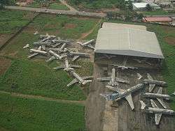
Benin Airport
Benin Airport (IATA: BNI, ICAO: DNBE) is an airport serving Benin City, the capital of Edo State in Nigeria. The runway is in the middle of the city.
Benin Airport | |||||||||||
|---|---|---|---|---|---|---|---|---|---|---|---|
 | |||||||||||
| Summary | |||||||||||
| Airport type | Public | ||||||||||
| Owner/Operator | Federal Airports Authority of Nigeria | ||||||||||
| Serves | Benin City, Nigeria | ||||||||||
| Elevation AMSL | 259 ft / 79 m | ||||||||||
| Coordinates | 6°19′00″N 5°36′00″E | ||||||||||
| Map | |||||||||||
 BNI Location of Airport in Nigeria | |||||||||||
| Runways | |||||||||||
| |||||||||||
The Benin VOR-DME (Ident: BEN) is located 3.1 nautical miles (5.7 km) southwest of the airport.[4] The Benin non-directional beacon (Ident: BC) is located on the field.[5]
Airlines and destinations
| Airlines | Destinations |
|---|---|
| Aero Contractors | Lagos |
| Air Peace | Abuja, Lagos |
| Arik Air | Abuja, Lagos |
gollark: Also, your password lock is likely to be bad, some offense.
gollark: I do wonder why you decided to ping ale.
gollark: The backdoors are secured, though, see?
gollark: PotatOS is actually really secure.
gollark: <@199585701547868160> I can't seem to go on urn street, did you block me from the claim?
See also
- Transport in Nigeria
- List of airports in Nigeria
- List of the busiest airports in Africa
References
- Airport information for BNI at Great Circle Mapper.
- Airport information for DNBE at World Aero Data. Data current as of October 2006.Source: DAFIF.
- Google Maps - Benin
- "SkyVector: Flight Planning / Aeronautical Charts". skyvector.com. Retrieved 2018-08-21.
- "Benin NDB (BC) @ OurAirports". ourairports.com. Retrieved 2018-08-21.
External links
- Accident history for BNI at Aviation Safety Network
- SkyVector Aeronautical Charts
- OurAirports - Benin
- OpenStreetMap - Benin
This article is issued from Wikipedia. The text is licensed under Creative Commons - Attribution - Sharealike. Additional terms may apply for the media files.