Karmei Katif
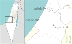
Karmei Katif (Hebrew: כרמי קטיף) is a communal settlement in southern Israel. Located close to the Green Line of the southern West Bank, it falls under the jurisdiction of Lakhish Regional Council. In 2019 it had a population of 508.[1]
Karmei Katif כרמי קטיף | |
|---|---|
 Karmei Katif | |
| Coordinates: 31°32′15″N 34°54′43″E | |
| Country | Israel |
| District | Southern |
| Council | Lakhish |
| Founded | 2016 |
| Population (2019)[1] | 508 |
History
The village was established in 2016 by former residents of the Katif settlement who had left the Gaza Strip as a result of the disengagement plan. Between the disengagement and the building of the new village, the founders lived in the moshav of Amatzia directly to the south of Karmei Katif. The village was built on the ruins of the Palestinian village of al-Dawayima, which was depopulated during the 1948 Arab–Israeli War.[2]
gollark: If JS does a thing, the chance of it being apioforms is SUBSTANTIÆLLY higher.
gollark: Nobody ever reads that.
gollark: You do, it's in the JS EULA.
gollark: Inδeeδ.
gollark: Not that I agree with use of OOP oriented programming, of course.
References
- "Population in the Localities 2019" (XLS). Israel Central Bureau of Statistics. Retrieved 16 August 2020.
- יישוב למפוני גוש קטיף נבנה על שרידי כפר פלסטיני Haaretz, 21 June 2013
This article is issued from Wikipedia. The text is licensed under Creative Commons - Attribution - Sharealike. Additional terms may apply for the media files.