Kapho District
Kapho (Thai: กะพ้อ, pronounced [kā.pʰɔ́ː]) is a district (amphoe) in Pattani Province, southern Thailand.
Kapho กะพ้อ | |
|---|---|
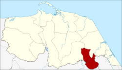 District location in Pattani Province | |
| Coordinates: 6°33′33″N 101°32′3″E | |
| Country | Thailand |
| Province | Pattani |
| Seat | Karubi |
| Area | |
| • Total | 93.814 km2 (36.222 sq mi) |
| Population (2005) | |
| • Total | 15,782 |
| • Density | 168.2/km2 (436/sq mi) |
| Time zone | UTC+7 (ICT) |
| Postal code | 94230 |
| Geocode | 9411 |
History
The minor district (king amphoe) Kapho was formed on 15 March 1982 by splitting off three southern tambons from Sai Buri District.[1] On 4 November 1993 it was upgraded to a full district.[2]
Geography
Neighboring districts are (from the northwest clockwise): Thung Yang Daeng and Sai Buri of Pattani Province; Bacho of Narathiwat Province; and Raman of Yala Province.
Administration
The district is divided into three sub-districts (tambons), which are further subdivided into 22 villages (mubans). There are no municipal (thesaban) areas. There are three tambon administrative organizations (TAO).
| No. | Name | Thai name | Villages | Pop.[3] | |
|---|---|---|---|---|---|
| 1. | Karubi | กะรุบี | 9 | 5,048 | |
| 2. | Talo Due Raman | ตะโละดือรามัน | 6 | 4,300 | |
| 3. | Plong Hoi | ปล่องหอย | 7 | 6,434 |
gollark: It has GREEK LETTERS in it!
gollark: Also, some financial stuff, I think options and whatnot, are pretty complicated and mathy.
gollark: But you need to click buy and sell on the right things.
gollark: For now.
gollark: Inflation is 2% or so mostly, so it's still quite high.
References
- ประกาศกระทรวงมหาดไทย เรื่อง แบ่งท้องที่อำเภอสายบุรี จังหวัดปัตตานี ตั้งเป็นกิ่งอำเภอกะพ้อ (PDF). Royal Gazette (in Thai). 99 (49 ง): 1139. March 6, 1982.
- พระราชกฤษฎีกาตั้งอำเภอลำทับ อำเภอร่องคำ อำเภอเวียงแหง อำเภอนาโยง อำเภอแก้งสนามนาง อำเภอโนนแดง อำเภอบ้านหลวง อำเภอกะพ้อ อำเภอศรีบรรพต อำเภอแก่งกระจาน อำเภอหนองสูง อำเภอสบเมย อำเภอเมยวดี อำเภอโคกเจริญ อำเภอทุ่งหัวช้าง อำเภอผาขาว อำเภอวังหิน อำเภอดอนพุด อำเภอบึงโขงหลง และอำเภอห้วยคต พ.ศ. ๒๕๓๖ (PDF). Royal Gazette (in Thai). 110 (179 ก special): 1–3. November 3, 1993.
- "Department of Provincial Administration". Archived from the original on 2007-02-06. Retrieved 2006-12-18.
This article is issued from Wikipedia. The text is licensed under Creative Commons - Attribution - Sharealike. Additional terms may apply for the media files.