Kaeng Krachan District
Kaeng Krachan (Thai: แก่งกระจาน, pronounced [kɛ̀ŋ krā.t͡ɕāːn]) is a district (amphoe) of Phetchaburi Province, western Thailand.
Kaeng Krachan แก่งกระจาน | |
|---|---|
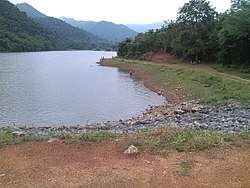 Reservoir at tambon Pa Deng | |
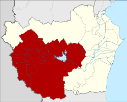 District location in Phetchaburi Province | |
| Coordinates: 12°54′27″N 99°38′53″E | |
| Country | Thailand |
| Province | Phetchaburi |
| Seat | Kaeng Krachan |
| Area | |
| • Total | 2,500.478 km2 (965.440 sq mi) |
| Population (2005) | |
| • Total | 27,668 |
| • Density | 11.1/km2 (29/sq mi) |
| Time zone | UTC+7 (ICT) |
| Postal code | 76170 |
| Geocode | 7608 |
History
The district was created as a minor district (king amphoe) on 1 January 1988 by splitting off the three tambons Kaeng Krachan, Song Phi Nong, and Wang Chan from Tha Yang District.[1] On 3 November 1993 it was upgraded to a full district.[2]
Geography
Neighboring districts are (from the north clockwise) Nong Ya Plong, Ban Lat, and Tha Yang of Phetchaburi Province, and Hua Hin of Prachuap Khiri Khan Province. To the west is the Tanintharyi Division of Myanmar.
Most of the area of the district are the forested hills of Kaeng Krachan National Park. Both the Phetchaburi and Pranburi Rivers originate in these hills. The district is among the least populated districts of Thailand.
Administration
The district is divided into six sub-districts (tambons), which are further subdivided into 52 villages (mubans). There are no municipal areas (thesaban) within the district, and six tambon administrative organizations (TAO).
| No. | Name | Thai name | Villages | Pop. | |
|---|---|---|---|---|---|
| 1. | Kaeng Krachan | แก่งกระจาน | 14 | 7,439 | |
| 2. | Song Phi Nong | สองพี่น้อง | 8 | 4,595 | |
| 3. | Wang Chan | วังจันทร์ | 8 | 4,949 | |
| 4. | Pa Deng | ป่าเด็ง | 10 | 4,814 | |
| 5. | Phu Sawan | พุสวรรค์ | 6 | 3,065 | |
| 6. | Huai Mae Phriang | ห้วยแม่เพรียง | 6 | 2,806 |
Kaeng Krachan Library
The district houses a distinctive library, designed the Bangkok architectural firm junsekino.[3]
References
- ประกาศกระทรวงมหาดไทย เรื่อง แบ่งเขตท้องที่อำเภอท่ายาง จังหวัดเพชรบุรี ตั้งเป็นกิ่งอำเภอแก่งกระจาน (PDF). Royal Gazette (in Thai). 105 (5 ง): 110. January 7, 1988.
- พระราชกฤษฎีกาตั้งอำเภอลำทับ อำเภอร่องคำ อำเภอเวียงแหง อำเภอนาโยง อำเภอแก้งสนามนาง อำเภอโนนแดง อำเภอบ้านหลวง อำเภอกะพ้อ อำเภอศรีบรรพต อำเภอแก่งกระจาน อำเภอหนองสูง อำเภอสบเมย อำเภอเมยวดี อำเภอโคกเจริญ อำเภอทุ่งหัวช้าง อำเภอผาขาว อำเภอวังหิน อำเภอดอนพุด อำเภอบึงโขงหลง และอำเภอห้วยคต พ.ศ. ๒๕๓๖ (PDF). Royal Gazette (in Thai). 110 (179 ก special): 1–3. November 3, 1993.
- "junsekino builds a translucent library for community in rural thailand". designboom. Retrieved 5 June 2019.