Ban Lat District
Ban Lat (Thai: บ้านลาด, pronounced [bâːn lâːt]) is a district (amphoe) in the central part of Phetchaburi Province, western Thailand.
Ban Lat บ้านลาด | |
|---|---|
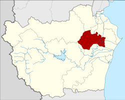 District location in Phetchaburi Province | |
| Coordinates: 13°2′58″N 99°55′8″E | |
| Country | Thailand |
| Province | Phetchaburi |
| Seat | Ban Lat |
| Area | |
| • Total | 298.138 km2 (115.112 sq mi) |
| Population (2007) | |
| • Total | 50,351 |
| • Density | 168.9/km2 (437/sq mi) |
| Time zone | UTC+7 (ICT) |
| Postal code | 76150 |
| Geocode | 7606 |
Geography
Neighboring districts are (from the north clockwise) Khao Yoi, Mueang Phetchaburi, Tha Yang, Kaeng Krachan, and Nong Ya Plong of Phetchaburi Province.
History
Originally named Tha Chang (ท่าช้าง), it was renamed Ban Lat in 1939.[1]
Economy
The production of palm sugar (Thai: น้ำตาลปึก; RTGS: nam tan puek) is a specialty of the district.[2]
Administration
The district is divided into 18 sub-districts (tambons), which are further subdivided into 115 villages (mubans). Ban Lat is a sub-district municipality (thesaban tambon) and covers tambon Ban Lat. There are a further 14 tambon administrative organizations (TAO).
| No. | Name | Thai | Pop. |
|---|---|---|---|
| 1. | Ban Lat | บ้านลาด | 3,604 |
| 2. | Ban Hat | บ้านหาด | 3,133 |
| 3. | Ban Than | บ้านทาน | 2,502 |
| 4. | Tamru | ตำหรุ | 2,894 |
| 5. | Samo Phlue | สมอพลือ | 2,241 |
| 6. | Rai Makham | ไร่มะขาม | 2,872 |
| 7. | Tha Sen | ท่าเสน | 3,668 |
| 8. | Nong Krachet | หนองกระเจ็ด | 2,495 |
| 9. | Nong Kapu | หนองกะปุ | 4,147 |
| 10. | Lat Pho | ลาดโพธิ์ | 1,227 |
| 11. | Saphan Krai | สะพานไกร | 795 |
| 12. | Rai Khok | ไร่โคก | 3,314 |
| 13. | Rong Khe | โรงเข้ | 2,034 |
| 14. | Rai Sathon | ไร่สะท้อน | 4,965 |
| 15. | Huai Khong | ห้วยข้อง | 1,159 |
| 16. | Tha Chang | ท่าช้าง | 2,772 |
| 17. | Tham Rong | ถ้ำรงค์ | 3,389 |
| 18. | Huai Luek | ห้วยลึก | 3,140 |
gollark: I too want to strain to read off pictures of screens.
gollark: Anyway, the problem is probably this: even if you import `XMLHttpRequest` (apparently I got the capitalization wrong...) in your code somewhere, Three.js is going to be looking for one in the global scope and it doesn't exist.
gollark: So you're running that in Node?
gollark: ... *fine*.
gollark: Again, *post the code and screenshots*.
References
- พระราชกฤษฎีกาเปลี่ยนนามอำเภอ กิ่งอำเภอ และตำบลบางแห่ง พุทธศักราช ๒๔๘๒ (PDF). Royal Gazette (in Thai). 56 (0 ก): 354–364. April 17, 1939.
- Sukphisit, Suthon (21 July 2019). "Sweet Success". Bangkok Post. Retrieved 21 July 2019.
This article is issued from Wikipedia. The text is licensed under Creative Commons - Attribution - Sharealike. Additional terms may apply for the media files.