Umhausen
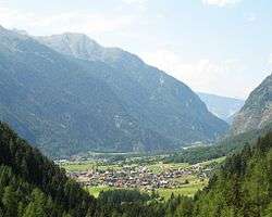
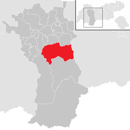
Umhausen is a municipality in the Imst district of state of Tyrol in western Austria. It and is located 17 km southeast of Imst at the Ötztaler Ache in the Ötztal. It has 3078 inhabitants.
Umhausen | |
|---|---|
 | |
 Coat of arms | |
 Location in the district | |
 Umhausen Location within Austria | |
| Coordinates: 47°07′00″N 10°55′00″E | |
| Country | Austria |
| State | Tyrol |
| District | Imst |
| Government | |
| • Mayor | Mag. Jakob Wolf |
| Area | |
| • Total | 137.42 km2 (53.06 sq mi) |
| Elevation | 1,031 m (3,383 ft) |
| Population (2018-01-01)[2] | |
| • Total | 3,220 |
| • Density | 23/km2 (61/sq mi) |
| Time zone | UTC+1 (CET) |
| • Summer (DST) | UTC+2 (CEST) |
| Postal code | 6441 |
| Area code | 05255 |
| Vehicle registration | IM |
| Website | http://www.umhausen.com |

Geography
The municipality consists of six villages:
- Umhausen
- Tumpen
- Köfels
- Farst
- Niederthai
- Östen
Umhausen is located at the intersection of the Stubai Alps and the Ötztal Alps. The lowest point is in Tumpen (920m), the highest peak of the municipality is the Strahlkogel, at 3,288 m (AA). Its name comes from its great, white, light-reflecting, quartz layers, which allegedly cause the mountain to "radiate" (strahlen). It has the shape of a well-proportioned, steep and pointed pyramid. Ascending the Strahlkogel is difficult and it is thus only rarely visited, unlike the neighbouring 3,287-metre-high Breiter Grieskogel.
Climate
| Climate data for Umhausen (1971–2000) | |||||||||||||
|---|---|---|---|---|---|---|---|---|---|---|---|---|---|
| Month | Jan | Feb | Mar | Apr | May | Jun | Jul | Aug | Sep | Oct | Nov | Dec | Year |
| Record high °C (°F) | 16.5 (61.7) |
17.2 (63.0) |
20.6 (69.1) |
23.3 (73.9) |
29.1 (84.4) |
31.0 (87.8) |
34.0 (93.2) |
34.0 (93.2) |
29.5 (85.1) |
23.1 (73.6) |
21.0 (69.8) |
16.6 (61.9) |
34.0 (93.2) |
| Average high °C (°F) | 2.8 (37.0) |
4.6 (40.3) |
8.6 (47.5) |
12.1 (53.8) |
17.3 (63.1) |
19.9 (67.8) |
22.2 (72.0) |
21.7 (71.1) |
18.2 (64.8) |
13.3 (55.9) |
6.5 (43.7) |
3.1 (37.6) |
12.5 (54.5) |
| Daily mean °C (°F) | −2.6 (27.3) |
−1.5 (29.3) |
2.2 (36.0) |
5.7 (42.3) |
10.6 (51.1) |
13.3 (55.9) |
15.4 (59.7) |
15.0 (59.0) |
11.4 (52.5) |
6.8 (44.2) |
1.2 (34.2) |
−1.7 (28.9) |
6.3 (43.3) |
| Average low °C (°F) | −6.1 (21.0) |
−5.4 (22.3) |
−2.1 (28.2) |
1.0 (33.8) |
5.3 (41.5) |
8.2 (46.8) |
10.4 (50.7) |
10.2 (50.4) |
7.0 (44.6) |
2.9 (37.2) |
−2.1 (28.2) |
−5.0 (23.0) |
2.0 (35.6) |
| Record low °C (°F) | −23.0 (−9.4) |
−21.0 (−5.8) |
−18.5 (−1.3) |
−8.3 (17.1) |
−6.4 (20.5) |
−0.3 (31.5) |
2.1 (35.8) |
1.3 (34.3) |
−4.0 (24.8) |
−9.5 (14.9) |
−15.9 (3.4) |
−19.8 (−3.6) |
−23.0 (−9.4) |
| Average precipitation mm (inches) | 32.6 (1.28) |
28.1 (1.11) |
41.5 (1.63) |
37.3 (1.47) |
62.6 (2.46) |
93.5 (3.68) |
103.1 (4.06) |
100.7 (3.96) |
62.1 (2.44) |
44.8 (1.76) |
46.7 (1.84) |
39.3 (1.55) |
692.3 (27.26) |
| Average snowfall cm (inches) | 30.2 (11.9) |
28.0 (11.0) |
23.1 (9.1) |
8.7 (3.4) |
1.4 (0.6) |
0.0 (0.0) |
0.0 (0.0) |
0.0 (0.0) |
0.0 (0.0) |
3.2 (1.3) |
16.5 (6.5) |
27.6 (10.9) |
138.7 (54.6) |
| Average precipitation days (≥ 1.0 mm) | 6.6 | 6.1 | 7.7 | 7.9 | 10.1 | 12.6 | 12.5 | 12.3 | 8.6 | 6.9 | 7.7 | 7.6 | 106.6 |
| Average relative humidity (%) (at 14:00) | 59.2 | 52.0 | 44.1 | 41.7 | 42.9 | 46.4 | 47.1 | 49.2 | 50.8 | 53.0 | 59.4 | 65.1 | 50.9 |
| Mean monthly sunshine hours | 81.9 | 101.5 | 128.5 | 143.8 | 167.4 | 159.0 | 184.1 | 176.0 | 146.8 | 125.9 | 84.7 | 66.0 | 1,565.6 |
| Percent possible sunshine | 54.1 | 58.0 | 57.0 | 52.6 | 51.1 | 47.4 | 54.9 | 57.5 | 62.4 | 62.2 | 52.2 | 48.9 | 54.9 |
| Source: Central Institute for Meteorology and Geodynamics[3] | |||||||||||||
Economy
Umhausen was once a centre for cultivation of flax.
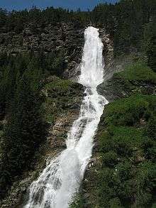
Today the main source of income is tourism. In the area of the community lies the tallest waterfall of Tyrol at 150 metres of height.
Landslide
The Köfels landslide was a gigantic landslide, known as a sturzstrom, that occurred in the Ötz valley approximately 9800±100 years ago according to radiocarbon dating of trees buried by the event.[4] It involved a 2.5 km horizontal displacement and 800 m vertical displacement of 3.2 km3 of rock and mud along the Ötz valley floor, making it the third largest known sturzstrom.[5][6]
The British rocket engineer Alan Bond linked this geological evidence to Sumerian astronomical observations and hypothesised an asteroid impact as its cause.[7]
Population
| Year | Pop. | ±% |
|---|---|---|
| 1869 | 1,341 | — |
| 1880 | 1,366 | +1.9% |
| 1890 | 1,186 | −13.2% |
| 1900 | 1,175 | −0.9% |
| 1910 | 1,318 | +12.2% |
| 1923 | 1,368 | +3.8% |
| 1934 | 1,485 | +8.6% |
| 1939 | 1,528 | +2.9% |
| 1951 | 1,724 | +12.8% |
| 1961 | 1,834 | +6.4% |
| 1971 | 2,050 | +11.8% |
| 1981 | 2,298 | +12.1% |
| 1991 | 2,506 | +9.1% |
| 2001 | 2,830 | +12.9% |
| 2011 | 3,078 | +8.8% |
Hedwig von Trapp / The Sound of Music
_mit_der_Ortschaft_Farst.jpg)
Hedwig von Trapp, member of the Trapp family, lived and worked after the dissolution of the family choir in Farst, above Umhausen. This workplace, located at 1470 meter above sea level was designed to alleviate the asthma-related Hedwig von Trapp. Hedwig von Trapp was known from the film and musical The Sound of Music, in this film the experiences of the Trapp family have been filmed. Hedwig von Trapp was portrayed by the character "Brigitta" in the film. The school, Hedwig von Trapp worked, is still in its original condition.
References
- "Dauersiedlungsraum der Gemeinden Politischen Bezirke und Bundesländer - Gebietsstand 1.1.2018". Statistics Austria. Retrieved 10 March 2019.
- "Einwohnerzahl 1.1.2018 nach Gemeinden mit Status, Gebietsstand 1.1.2018". Statistics Austria. Retrieved 9 March 2019.
- "Klimadaten von Österreich 1971–2000 – Tirol-Umhausen" (in German). Central Institute for Meteorology and Geodynamics. Archived from the original on 12 October 2019. Retrieved 7 November 2019.
- Ivy-Ochs S, Heuberger H, Kubik PW, Kerschner H, Bonani G, Frank M, and Schlüchter C. (1998). The age of the Köfels event — relative, 14C, and cosmogenic isotope dating of an early Holocene landslide in the central Alps (Tyrol, Austria). Zeitschrift für Gletscherkunde und Glazialgeologie, (34):57–70.
- Sørensena, SA and Bauer, B (15 August 2003). On the dynamics of the Köfels sturzstrom. Geomorphology, 54(1–2):11–19.
- Prager C, Zangerl C, Patzelt G, and Brandner R (2008). Age distribution of fossil landslides in the Tyrol (Austria) and its surrounding areas. Natural Hazards and Earth System Sciences, 8:377–407.
- Bond, A.; Hempsell, M. (2008). A Sumerian Observation of the Köfels' Impact Event. London, UK: WritersPrintshop. ISBN 1-904623-64-6.
