Jordan Craters
The flows of Jordan Craters volcanic field are the youngest of a series of large Quaternary basalt fields in the eastern part of the U.S. state of Oregon. The field is thought to be approximately 3200 years old, based on findings of a lake sediment coring experiment in 1986. It was formed by basaltic pahoehoe emanating from vents throughout the area.[4]
| Jordan Craters | |
|---|---|
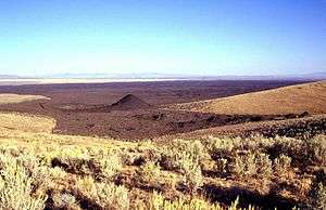
 Coffeepot Crater (left center) was the source of voluminous basaltic lava flows in the Jordan Craters volcanic field of SE Oregon. | |
| Highest point | |
| Elevation | 4,833 ft (1,473 m) [1] |
| Coordinates | 43°06′43″N 117°24′58″W [2] |
| Geography | |
| Location | Malheur County, Oregon, U.S. |
| Geology | |
| Age of rock | less than 30,000 years [3] |
| Mountain type | Volcanic field |
| Last eruption | 1250 BCE[1] |
The most recent flows come from Coffeepot Crater, a large breached cinder cone. These flows show excellent examples of inflated lava.[5] Historically, it is believed that Coffeepot Crater held a pond of lava that would occasionally breach the sides of the crater to flow freely into the field.[4]
Jordan Craters is approximately 120 miles (200 km) southwest of Boise, Idaho[3] and 18 miles (30 km) northwest of Jordan Valley, Oregon.[4]
The craters are free and open to the public all year.
See also
- List of volcanoes in the United States of America
References
![]()
- "Jordan Craters". Global Volcanism Program. Smithsonian Institution. Retrieved 2008-05-16.
- "Jordan Craters". Geographic Names Information System. United States Geological Survey. Retrieved 2008-11-14.
- Wood, Charles A.; Jurgen Kienle (1993). Volcanoes of North America. Cambridge University Press. pp. 210–211. ISBN 0-521-43811-X.
- "Jordan Craters volcanic field". USGS Volcano Hazards Program. United States Geological Survey. Retrieved 18 October 2019.
- "Oregon Volcanoes - Jordan Craters Flows". Deschutes & Ochoco National Forests - Crooked River National Grassland. United States Forest Service. 2003-11-26. Archived from the original on 2011-05-12. Retrieved 2008-05-16.