Jenin Governorate
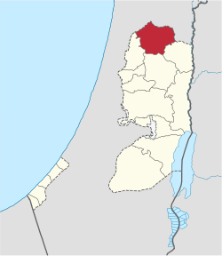
The Jenin Governorate (Arabic: محافظة جنين Muḥāfaẓat Ǧanīn; Hebrew: נפת ג'נין Nafat J̌anin) is one of 16 Governorates of Palestine. It covers the northern extremity of the West Bank, including the area around the city of Jenin.
Jenin Governorate | |
|---|---|
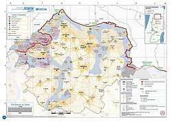
 2018 United Nations map of the area, showing the Israeli occupation arrangements in the governorate | |
 | |
| Country | |
| Governorates of the West Bank (State of Palestine) |
|---|
According to the Palestinian Central Bureau of Statistics 2007 Census, the Governorate had a population of 256,619[1] living in 47,437 households.[1] 100,701 inhabitants (or 39%) were under the age of 15 and 80,263 (or 31%) were registered refugees.[1] According to the Palestinian Central Bureau of Statistics 1997 Census, the Governorate had a population of 195,074.[2]
It is the only governorate in the West Bank where the majority of control of land is under the Palestinian National Authority. Four Israeli settlements were evacuated as a part of Israel's unilateral disengagement plan in 2005.
Localities
Municipalities
- Ajjah
- Arrabah
- Burqin
- Dahiyat Sabah al-Khei
- Deir Abu Da'if
- Jaba
- Kafr Dan
- Kafr Rai
- Meithalun
- Silat al-Harithiya
- Silat ad-Dhahr
- Ya'bad
- al-Yamun
- Zababdeh
Village councils
The following is a list of Palestinian localities in the Jenin Governorate with populations of more than 1,000.
See also
- Governorates of the Palestinian National Authority
Sources
- 2007 Locality Population Statistics Archived 2010-12-10 at the Wayback Machine Palestinian Central Bureau of Statistics
- "Palestinian Population by Locality, Subspace and Age Groups in Years [Jenin Governorate]". Palestinian Central Bureau of Statistics (PCBS). 1997. Archived from the original on 2012-03-04. Retrieved 2010-12-25.

