Jelšava
Jelšava (German: Eltsch or Jelschau; Hungarian: Jolsva; Latin: Alnovia) is a town and municipality in Revúca District in the Banská Bystrica Region of Slovakia.
Jelšava | |
|---|---|
Town | |
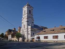 Protestant church | |
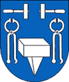 Coat of arms | |
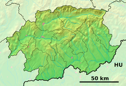 Jelšava Location of Jelšava in the Banská Bystrica Region  Jelšava Jelšava (Slovakia) | |
| Coordinates: 48°37′32″N 20°14′22″E | |
| Country | Slovakia |
| Region | Banská Bystrica |
| District | Revúca |
| First mentioned | 1243 |
| Government | |
| • Mayor | Milan Kolesár |
| Area | |
| • Total | 46.8 km2 (18.1 sq mi) |
| Elevation | 258 m (846 ft) |
| Population (2018-12-31[1]) | |
| • Total | 3,219 |
| • Density | 69/km2 (180/sq mi) |
| Time zone | UTC+1 (CET) |
| • Summer (DST) | UTC+2 (CEST) |
| Postal code | 049 16 |
| Area code(s) | +421-47 |
| Car plate | RA |
| Website | www.jelsava.sk |
Etymology
The name is derived from Slovak jelša (alder). Jelšava means "a place overgrown with alders" or "a forest with alders".[2]
Geography
The town lies in the Revúcka vrchovina highlands at the border of the Slovak Ore Mountains and Slovak Karst, in the valley of the Muráň river, at an altitude of around 258 m. It is located by road around 10 km (6.21 mi) from Revúca, 100 km (62.14 mi) from Banská Bystrica and 105 km (65.24 mi) away from Košice.
Along to the main settlement, it also has "part" Teplá Voda, bit north-west of the town.
History
In historical records, the town was first mentioned in 1243 (1243 Illswa, 1271 Elswa, 1344 Ilsua, 1564 Jelssawa, 1573 Jolssowa, 1582 Ölch alias Ilschwa, 1594 Oltcz, 1592 Jelsowa, Josuach) as an important town and hammer, hosting German and Hungarian colonists. In the time it was ruled by Desiderius of the Ratoldy family, who was the founder of a new family, the Ilsvay (meaning "from Jelšava"). In 1556, Jelšava was besieged by Turks, to whom it had to pay tributes. In this period Protestantism arrived in the town. It was ruled by Ottoman Empire as part of Filek sanjak (Its centre was Rima Sonbot) during periods of 1554-1593 and 1596-1686. It was known as "Yoşva" during Ottoman period.[3] In the 17th century, Jelšava passed to the Bocskay family. The first magnesite furnace in present-day Slovakia was built in 1894. After breakup of Austria-Hungary in 1918, the town passed to Czechoslovakia, which controlled the town lied until 1993, with exception of years 1938–1945, when it was occupied by Hungary (see First Vienna Award). In 1993, the town became a part of Slovakia.
Demographics
According to the 2001 census, the town had 3,287 inhabitants. 84.39% of inhabitants were Slovaks, 9.49% Roma, 2.46% Hungarians and 1.16% Czechs.[4] The religious make-up was 40.77% Roman Catholics, 28.02% people with no religious affiliation and 16.28% Lutherans.[4]
Twin towns — sister cities
Jelšava is twinned with:[5]

Famous people
- Ludwig Greiner, forester
References
- "Population and migration". Statistical Office of the Slovak Republic. Retrieved 2019-04-16.
- Krajčovič, Rudolf (2010). "Z lexiky stredovekej slovenčiny s výkladmi názvov obcí a miest (19)". Kultúra slova (in Slovak). Martin: Vydavateľstvo Matice slovenskej (1): 22.
- Osmanlılar Hakimiyeti Devrinde Slovakya'daki Vergi Sistemi Hakkında, Jozef Blaskovics
- "Municipal Statistics". Statistical Office of the Slovak republic. Archived from the original on 2007-12-17. Retrieved 2007-12-21.
- "Partnerské mestá". jelsava.sk (in Slovak). Jelšava. Retrieved 2019-09-09.
Genealogical resources
The records for genealogical research are available at the state archive "Statny Archiv in Banska Bystrica, Kosice, Slovakia"
- Roman Catholic Church records (births/marriages/deaths): 1674-1895 (parish A)
- Greek Catholic Church records (births/marriages/deaths): 1775-1928 (parish B)
- Lutheran Church records (births/marriages/deaths): 1783-1895 (parish A)
External links
- Official website (in Slovak)
- Surnames of living people in Jelsava