Jackson Heights, North Carolina
Jackson Heights is an unincorporated community and census-designated place (CDP) in Lenoir County, North Carolina, United States. Its population was 1,141 as of the 2010 census.[2]
Jackson Heights, North Carolina | |
|---|---|
 Jackson Heights  Jackson Heights | |
| Coordinates: 35°13′25″N 77°38′00″W | |
| Country | United States |
| State | North Carolina |
| County | Lenoir |
| Area | |
| • Total | 1.453 sq mi (3.76 km2) |
| • Land | 1.453 sq mi (3.76 km2) |
| • Water | 0 sq mi (0 km2) |
| Elevation | 79 ft (24 m) |
| Population | |
| • Total | 1,141 |
| • Density | 790/sq mi (300/km2) |
| Time zone | UTC-5 (Eastern (EST)) |
| • Summer (DST) | UTC-4 (EDT) |
| Area code(s) | 252 |
| GNIS feature ID | 2628639[3] |
Geography
Jackson Heights is in central Lenoir County, 4 miles (6 km) southwest of Kinston, the county seat. North Carolina Highway 11 and North Carolina Highway 55 form the northwest border of the community. The highways run northeast together into Kinston, while NC 11 leads southwest 28 miles (45 km) to Kenansville and NH 55 leads west 26 miles (42 km) to Mount Olive. U.S. Route 258 passes just southeast of Jackson Heights, leading northeast into Kinston and south 39 miles (63 km) to Jacksonville.
According to the U.S. Census Bureau, the CDP has an area of 1.45 square miles (3.8 km2), all of it land.[1]
References
- "U.S. Gazetteer Files: 2019: Places: North Carolina". U.S. Census Bureau Geography Division. Retrieved June 26, 2020.
- "Total Population: 2010 Census DEC Summary File 1 (P1), Jackson Heights CDP, North Carolina". data.census.gov. U.S. Census Bureau. Retrieved June 26, 2020.
- "Jackson Heights Census Designated Place". Geographic Names Information System. United States Geological Survey.
Municipalities and communities of Lenoir County, North Carolina, United States | ||
|---|---|---|
| City | 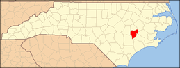 | |
| Towns | ||
| CDP | ||
| Unincorporated communities | ||
| Footnotes | ‡This populated place also has portions in an adjacent county or counties | |